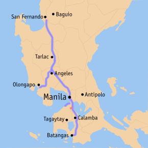
Muntinlupa–Cavite Expressway
| |
|---|---|
| Daang-Hari–SLEX Link Expressway | |
 Map of expressways in Luzon, with the Muntinlupa–Cavite Expressway in red | |
| Route information | |
| Length | 4.0 km (2.5 mi) |
| Existed | 2015 – present |
| Component highways |
|
| Major junctions | |
| East end |
|
| West end | Daang Hari and Daang Reyna Road junction in Cavite |
| Location | |
| Major cities | Muntinlupa, Las Piñas, Bacoor, Imus |
| Highway system | |
|
Roads in the Philippines | |
.svg.png)
The Muntinlupa–Cavite Expressway, more commonly known as MCX and formerly as Daang Hari–SLEX Link Expressway, is a 4 km (2.5 mi) long access-controlled toll expressway linking the southern province of Cavite to Muntinlupa in the Philippines. It is owned by the Department of Public Works and Highways and operated by AC Infrastructure Holdings Corporation, a subsidiary of Ayala Corporation.
At the east end, it feeds into and from the South Luzon Expressway in the city of Muntinlupa in Metro Manila. At the west end, it feeds into the junction of Daang Hari Road and Daang Reyna Road near the city's borders with Las Piñas and Bacoor.
The expressway was opened to traffic on July 24, 2015.[1]
The expressway is designated as a spur component of Expressway Route 2 (E2) of the Philippine expressway network.
Route description
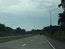
Muntinlupa–Cavite Expressway acts as a connector between Daang Hari and South Luzon Expressway. The expressway passes near the vicinity of New Bilibid Prisons and Southville 2A, one of the relocation areas of squatters who once lived beside the Philippine National Railways lines.
The expressway starts with the T-interchange with South Luzon Expressway near Susana Heights. It follows a slight curving route paralleling Magdaong Creek, which acts as a boundary between Poblacion and Tunasan. It soon passes near the New Bilibid Prisons, where several access roads are rerouted with the construction of the expressway. The expressway ends at a roundabout with Daang Hari and Daang Reyna.
Technical specifications
- Name: Muntinlupa–Cavite Expressway
- Concession holder: Ayala Corporation
- Operator: Ayala Corporation
- Length: 4 km
- Concession starting date: 2015
- Concession ending date: 2045
- Highway exits: 2
- Toll plazas: 1
- Rest and Service Areas: none
- Minimum Height Clearance on Underpasses:
Toll
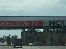
Tolls are assessed in each direction at the toll barrier, based on class. An interoperability agreement signed by the operators of the Muntinlupa–Cavite and South Luzon Expressways was signed three days before the formal opening of the former.[2] The result of the agreement is that motorists using the Muntinlupa–Cavite Expressway will have to pay a toll fee depending on the vehicle class in addition to the toll fee from the South Luzon Expressway and/or the Metro Manila Skyway to Susana Heights Exit.[3] In accordance with law, all toll rates include a 12% Value-Added Tax.
| Class | Toll |
|---|---|
| Class 1 (Cars, Motorcycles, SUVs, Jeepneys) |
₱17.00 |
| Class 2 (Buses, Light Trucks) |
₱34.00 |
| Class 3 (Heavy Trucks) |
₱51.00 |
Exits
No kilometer markers are posted anywhere on the road.
| Province | City/Municipality | km | mi | Destinations | Notes |
|---|---|---|---|---|---|
| Muntinlupa | T-interchange. Eastern terminus. No entrance from Susana Heights Access Road. | ||||
| MCX toll plaza | |||||
| Muntinlupa–Las Piñas boundary | Daang Hari Road – Cavite, Las Piñas, Vista City | Roundabout. Western terminus. | |||
1.000 mi = 1.609 km; 1.000 km = 0.621 mi
| |||||
References
- ↑ Valiente, Catherine S. (24 July 2015). "Aquino opens Muntinlupa–Cavite Expressway". The Manila Times. Retrieved 24 July 2015.
- ↑ ABS-CBNnews.com (21 July 2015). "Ayala, San Miguel sign interoperability deal for MCX". Retrieved 28 July 2015.
- ↑ Tabamo, Dinzo (25 July 2015). "The new Muntinlupa-Cavite Expressway is now open". TopGear.com.ph. Summit Media. Retrieved 28 July 2015.
| Operational | |
|---|---|
| Planned |
|
| Under construction | |
See also: Philippine expressway network | |
| Expressways |
| ||||||||
|---|---|---|---|---|---|---|---|---|---|
| National roads |
| ||||||||
| Arterial Routes |
| ||||||||
Coordinates: 14°22′37″N 121°1′37″E / 14.37694°N 121.02694°E