Kreitzer Glacier
See also: Kreitzerisen
| Kreitzer Glacier | |
|---|---|
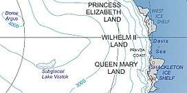 Location of Princess Elizabeth Land | |
 Location of Kreitzer Glacier in Antarctica | |
| Location | Princess Elizabeth Land |
| Coordinates | 70°22′S 72°36′E / 70.367°S 72.600°E / -70.367; 72.600 |
| Thickness | unknown |
| Terminus | Amery Ice Shelf |
| Status | unknown |
Kreitzer Glacier (70°22′S 72°36′E / 70.367°S 72.600°E / -70.367; 72.600Coordinates: 70°22′S 72°36′E / 70.367°S 72.600°E / -70.367; 72.600) is a glacier flowing northwest between Jennings Promontory and the Reinbolt Hills into the eastern part of the Amery Ice Shelf, Antarctica. It was delineated in 1952 by John H. Roscoe from aerial photographs taken by U.S. Navy Operation Highjump, 1946–47, and was named by Roscoe for Lieutenant William R. Kreitzer, U.S. Navy, commander of one of the three Operation Highjump aircraft used in photographing this and other coastal areas between 14°E and 164°E.[1]
See also
References
- ↑ "Kreitzer Glacier". Geographic Names Information System. United States Geological Survey. Retrieved 2013-05-17.

External links
| Types | |||||||
|---|---|---|---|---|---|---|---|
| Anatomy | |||||||
| Processes | |||||||
| Measurements | |||||||
| Volcanic relations | |||||||
| Landforms |
| ||||||
| |||||||
Glaciers of Princess Elizabeth Land | |
|---|---|
This article is issued from
Wikipedia.
The text is licensed under Creative Commons - Attribution - Sharealike.
Additional terms may apply for the media files.