Hargreaves Glacier
Not to be confused with Hargreavesbreen.
| Hargreaves Glacier | |
|---|---|
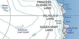 Location of Princess Elizabeth Land | |
 Location of Hargreaves Glacier in Antarctica | |
| Location | Princess Elizabeth Land |
| Coordinates | 69°46′S 74°20′E / 69.767°S 74.333°E / -69.767; 74.333 |
| Length | 2 nmi (4 km; 2 mi) |
| Thickness | unknown |
| Terminus | Ingrid Christensen Coast |
| Status | unknown |
Hargreaves Glacier (69°46′S 74°20′E / 69.767°S 74.333°E / -69.767; 74.333Coordinates: 69°46′S 74°20′E / 69.767°S 74.333°E / -69.767; 74.333) is a glacier 2 nautical miles (4 km) west of Mount Caroline Mikkelsen on the Ingrid Christensen Coast of Antarctica. It drains into the central part of the head of Sandefjord Ice Bay. The glacier was delineated in 1952 by John H. Roscoe from aerial photographs taken by U.S. Navy Operation Highjump, 1946–47, and was named by him for R.B. Hargreaves, an aerial photographer on Operation Highjump flights in the area.[1]
See also
References
- ↑ "Hargreaves Glacier". Geographic Names Information System. United States Geological Survey. Retrieved 2012-05-23.

Glaciers of Princess Elizabeth Land | |
|---|---|
This article is issued from
Wikipedia.
The text is licensed under Creative Commons - Attribution - Sharealike.
Additional terms may apply for the media files.