Thai highway network

The Thai highway network follows the left-hand traffic rule of the road. The network is the twin responsibility of the Department of Highways (DOH, Thai: กรมทางหลวง, Krom Thang Luang), and the Department of Rural Roads (DORR, กรมทางหลวงชนบท, Krom Thang Luang Chonnabot), under the oversight of the Transportation ministry of Thailand. Public highways (ทางหลวง, thang luang) are also called public roads (ถนนหลวง, thanon luang), especially when part of urban streets. The network spans over 70,000 kilometers across all regions of Thailand.[1] Most are single carriageways. Dual carriageways have frequent u-turn lanes and intersections slowing down traffic. Coupled with the increase in the number of vehicles and the demand for a limited-access motorway, the Thai Government issued a Cabinet resolution in 1997 detailing the motorway construction master plan.[2] Some upgraded sections of highway are being turned into a "motorway", while other motorways are not being built from highway sections.
Types of highways
The 1992 Highway Act (Thai: พระราชบัญญัติทางหลวง พ.ศ. 2535), revised as the 2006 Highway Act (Thai: พระราชบัญญัติทางหลวง (ฉบับที่ 2) พ.ศ. 2549), defines the following five highway types:[3]
A special highway (Thai: ทางหลวงพิเศษ) or motorway is a high capacity highway designed for high speed traffic, for which the Department of Highways carries out construction, expansion, upkeep and repairs, and is registered as such. Motorway entrances and exits have controlled access, and controlled by the DOH. Registration of motorways is overseen by the Director General of the DOH.
A national highway (Thai: ทางหลวงแผ่นดิน) is a primary highway, part of the network connecting regions, provinces, districts, and other important destinations, for which the DOH carries out construction, expansion, upkeep and repairs. Registration of national highways is overseen by the Director General of the DOH.
A rural highway (Thai: ทางหลวงชนบท) or rural road is a highway for which the Department of Rural Roads carries out construction, expansion, upkeep and repairs. Registration of rural highways is overseen by the Director General of the DORR.
A local highway (Thai: ทางหลวงท้องถิ่น) or local route is a highway for which the local administrative organization carries out construction, expansion, upkeep and repairs. Registration of rural highways is overseen by the provincial governor.
A concession highway (Thai: ทางหลวงสัมปทาน) is a highway for which a legal government concession has been granted. Registration of concession highways is overseen by the Director General of the DOH.
Highway numbering
The first digit of a highway number indicates the region of Thailand it serves, with the number of digits indicating the highway classification.[4] These regions are:
- Northern Thailand.
- Northeastern Thailand.
- Central and eastern, including the upper south.
- Southern Thailand, except the upper south.
A single digit indicates one of four highways connecting Bangkok to outlying regions:[4]
- Route 1 (Phahonyothin Road) to northern Thailand
- Route 2 (Mittraphap Road) to northeastern Thailand
- Route 3 (Sukhumvit Road) to eastern Thailand
- Route 4 (Phet Kasem Road) to southern Thailand
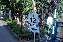
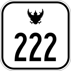
Two digits indicate a principal highway within a region, such as Route 22 in the northeast between Udon Thani and Nakhon Phanom.[4]
Three digits indicate a regional secondary highway, such as northeastern Route 202 between Chaiyaphum and Khemarat, and central Route 314 between Bang Pakong and Cha Choeng Sao.[4]
Four digits indicate an intra-province highway connecting a provincial capital to its districts, or between important sites, such as northern Route 1001 between the Route 11 intersection and Amphoe Phrao, and southern Route 4006 between the Route 4 intersection (Ratchakrut) and Lang Suan.[4]
Highways by region
Northern Thailand


- Route 1047: Route 11 (Pa Khun) - Muang Chet Ton (now superseded by Route 117)


- Route 1080: Nan - Lao border at Huai Kon (now superseded by Route 101)


- Route 1085: Mae Sot - Mae Sariang (now superseded by Route 105)


- Route 1091


- Route 1094


- Route 1100
- Route 1101
- Route 1102
- Route 1103
- Route 1104: Wang Kaphi - Phrom Phiram (now superseded by Route 117)
- Route 1325: Route 12 (Phitsanulok) - Naresuan Dam (now superseded by Route 117)
Northeastern Thailand


- Route 288 (Mueang Buriram Ring Road)

- Route 291: Mahasarakham Bypass Road
- Route 292: Yasothon Bypass Road
- Route 293: Surin Bypass Road
- Route 294: Sisaket Bypass Road
- Route 295: Entrance to bridge over the Mekong River (Nakhom Phanom)
- Route 2027: Route 22 (Phang Khom) - Waritchaphum (now superseded by Route 227)
- Route 2042: Somdet, Kalasin-Mukdahan (now superseded by Route 12)
- Route 2057: Ben Phai - Mancha Khiri (now superseded by Route 229)
- Route 2169 (Warirachadet Road ถนนวารีราชเดช): Yasothon Route 23-Bypass north to Amphoe Sai Mun–Kut Chum–Thai Charoen–Loeng Nok Tha–Route 2047, thence east 5 km to NS Route 212

Central Thailand including eastern region


- Route 3001: Entrance to barracks at Chiraprawat

- Route 3005
- Route 3006
- Route 3008
- Route 3010
- Route 3012
- Route 3013


- Route 3017

- Route 3020
- Route 3021
- Route 3022

- Route 3027
- Route 3028
- Route 3030
- Route 3032
- Route 3033
- Route 3034

- Route 3038
- Route 3039

- Route 3041
- Route 3042
- Route 3043
- Route 3044: Sao Hai – Nong Saeng (now part of Route 3041)
- Route 3045
- Route 3046
- Route 3047: Mueang Phuket – Nong Saeng (now part of Route 3041)
- Route 3048
- Route 3049: Route 33, Mueang Nakhon Nayok – Nang Rong Falls (Nakhon Nayok Province)
- Route 3050: Entrance to Sarika Waterfall (Nakhon Nayok Province)
- Route 3051
- Route 3052
- Route 3056
- Route 3062: Route 309 (Wat Pun) – Bang Pahan (designation decommissioned)
- Route 3063

- Route 3065 Pho Thong – Sawaeng Ha (now part of Route 3064)
- Route 3066: Rangsit – Pratunam Chulalongkorn (designation decommissioned)
- Route 3067
- Route 3068: Aranyaprathet–Lahan Sai (redesignated as Route 348)
- Route 3069
- Route 3070
- Route 3076
- Route 3077
- Route 3078
- Route 3079
- Route 3080: Entrance to Potharam


- Route 3085 Yangko-Lamsai-Simongkhon
- Route 3086 Latña-Boploi-Danchang
- Route 3087 Ratchaburi-Käm'on
- Route 3088 Ratchaburi-Wandao
- Route 3089: Khao Ngu Stone Park – Route 323 (Ratchaburi Province) (now part of Route 3291)
- Route 3090

- Route 3092
- Route 3093
- Route 3094: Entrance to Nakhon Chai Si


- Route 3102 (Sanphawut Road): Bang Na – Route 3109 (Bangkok)


- Route 3113 (Phuchao Saming Phray Road): Route 3 – Bhumibol Bridge (Mueang Samut Prakan)


- Route 3136 (North Pattaya Road)


- Route 3202 (Nawamin Road, Thai: ถนนนวมินทร์): Khan Na Yao - Bang Kapi (Bangkok), downgraded to local road


Southern Thailand


- Route 411: Krabi town route (downgraded to local road)


- Route 4012 : a short route between Ban Tha Pae and Nakhon Si Thammarat Town.
- Route 4054 (Padang Besar-Sadao Highway): Padang Besar–Songkhla.
- Route 4056 (Sungai Padi Road): Manang Tayo-Sungai Golok
- Route 4106 (Pattani-Betong Highway): Pattani–Betong.
- Route 4184 (Wang Prachan Road) (Sadao).
(Please expand)
Department of Highway signage
Route number signs
DOH signs for public highways (ทางหลวง, thang luang) are white squares with a black garuda (ครุฑ khrut) centered above the route number.
Signs near the beginning of a route may display the highway's name on a white rectangle above or below the square.
Highways bypassing city centres bear the principal route number marked "Bypass" in Thai (เลี่ยงเมือง), and sometimes also in English.
Department of Rural Roads
DORR rural roads do not follow the regional numbering scheme, above.
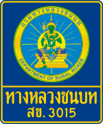
Signs may be black-on-white or gold-on-blue, with a two-letter province designation prefixed to the road number. Depicted is SK. 3015, for a rural road in Songkhla Province. The rural road network measures some 35,000 km, about 82 percent of which is paved. The Department of Rural Roads of the Ministry of Transport takes care of the maintenance of all the rural roads in Thailand.[5]
Kilometer stones
- Milestone as goal is lakh chai (หลักชัย); also see Lak Mueang, Lakh.

Lak or Lakh kilomet (หลักกิโลเมตร) single-carriageway kilometer stone facings display the route number on the outline of a garuda. Some kilometer stones also display the route number on top. Those located to the left of the carriageway display kilometers remaining to the road's beginning at kilometer 0. As seen on the right from the opposite lane, the kilometre stones ascend in value as one proceeds away from kilometer 0. On edges facing traffic, DOH kilometer stones usually show distances remaining to the next two towns, (amphoe seats, or provincial capitals.) Some edges, such as the one depicted to the left, have retroreflector panels. Dual carriageway kilometre stones or posts in the median strip show only the kilometre number.
DORR milestones show the kilometre number, and the edges may show distances remaining to the next two villages.
Older roads built by the Ministry of the Interior Public Works Department (กรมโยธาธิการ กระทรวงมหาดไทย) have only departmental insignia and kilometre number, and do not show distances on their edges.
This type of kilometre stone is sometimes found on older rural highways built during a period of rural development several decades ago. They are marked with the Thai characters รพช, an abbreviation for Rengrat Pattana Chonabot (เร่งรัดพัฒนาชนบท) which, roughly translated, means Rapid Rural Development.
See also
References
- ↑ Thailand Public Relations Department Transport and Communication. Retrieved October 14, 2008. Archived March 1, 2012, at the Wayback Machine.
- ↑ Paper "Privatization of Highway Infrastructure in Thailand" Bureau of Planning, Department of Highways, Thailand. Retrieved 2008-10-19. Archived July 11, 2012, at the Wayback Machine.
- ↑ DOH website, ประเภททางหลวง, retrieved on November 13, 2008 Archived December 11, 2011, at the Wayback Machine.
- 1 2 3 4 5 "ระบบหมายเลขทางหลวง". Department of Highways website. Department of Highways. Archived from the original on 5 October 2011. Retrieved 13 August 2011.
- ↑ World Bank, Transport in Thailand. Retrieved October 14, 2008.
External links
- Asian / ASEAN Highway Route Marker (21MB) Department of Highways Thai-language 18-page file, with 1 index and 8 regional maps of AH system overlaid on existing Thai national highways, plus diagrams of AH route markers. Retrieved 2008-10-14.
Road infrastructure in Thailand | |||||||||
|---|---|---|---|---|---|---|---|---|---|
| Controlled-access highways |
| ||||||||
| Highways |
| ||||||||
Roads in Asia | |
|---|---|
| Sovereign states |
|
| States with limited recognition |
|
| Dependencies and other territories | |
| |