Saraburi Province
| Saraburi สระบุรี | |||
|---|---|---|---|
| Province | |||
 | |||
| |||
 Map of Thailand highlighting Saraburi Province | |||
| Country | Thailand | ||
| Capital | Saraburi | ||
| Government | |||
| • Governor | Bundit Theveethivarak (since October 2016) | ||
| Area | |||
| • Total | 3,577 km2 (1,381 sq mi) | ||
| Area rank | Ranked 56th | ||
| Population (2014) | |||
| • Total | 633,460[1] | ||
| • Rank | Ranked 42nd | ||
| • Density rank | Ranked 17th | ||
| Time zone | UTC+7 (ICT) | ||
| ISO 3166 code | TH-19 | ||


Saraburi (Thai: สระบุรี) is one of the central provinces (changwat) of Thailand. Neighboring provinces are (from north clockwise) Lopburi, Nakhon Ratchasima, Nakhon Nayok, Pathum Thani, and Ayutthaya. It is believed to have been constructed in the year 1548 during the reign of King Maha Chakkraphat of Ayutthaya as a centre for recruiting troops.
Geography
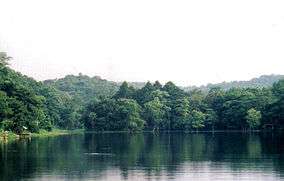
Saraburi is on the east side of the Chao Phraya River valley. The eastern part of the province is covered by high plains and plateaus, while the western part is mostly low flat plains. Saraburi Province has 2,235,304 acres of forest, including 460,522.25 acres of national forest (20.6 percent).
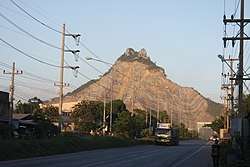
Two national parks are in the province. Namtok Chet Sao Noi protects 28 km2 around a scenic waterfall. Phra Puttachai protects the Khao Sam Lan Forest, which consists of hilly landscape and is the source to several rivers and waterfalls. The highest elevation is the Khao Khrok at 329 m. The 44.57 km2 area was declared a national park in 1981.
The town, as a gateway to the northeastern region, is 108 km from Bangkok. It occupies an area of 3,577 square kilometres.
History
Saraburi has been an important city since ancient times. It is assumed to have been established about 1549 during the reign of King Maha Chakkraphat of the Kingdom of Ayutthaya. It is assumed that the king ordered parts of Lopburi and Nakhon Nayok to be combined to set up Saraburi Province with the aim of mobilizing citizens during times of war. From the Ayutthaya period, the story of Saraburi is usually related to battles and wars. As for the origin of the word "Saraburi", it is assumed that due to its location near a swamp called "Bueng Nong Ngong", when the town was established a combination of sa ('swamp') and buri ('town') was suggested and the town was named "Saraburi".
Climate
Saraburi has a tropical savanna climate, Aw (Climate Classification system of Koppen) The climate is arid with little rain in winter, relatively high temperatures in summer, cool in winter, and rain from May to October, about 70-90 days
The average annual temperature is 28-29 degrees Celsius. Maximum temperatures average 33-34 degrees Celsius and minimum temperature averages 23-24 degrees Celsius. April is the hottest month of the year, while winters are cool in January.
Air quality
Saraburi has poor air quality resulting from cement production, chiefly stone crushing. There are six limestone mining sites and 38 mill stone plants in the area, most in the Na Pra Lan area.[2]
Education
There are 366 schools. There are a total of 125,255 students at all levels.
Economy
In 2007 Saraburi's population had an average income per capita 214,537 baht per year, making it tenth highest in the country, second in the central provinces. Annual GDP was 129,275 million baht.
Religion and culture
In 2007, Saraburi's population was 89.34 percent Buddhist, 597,138 people. There are 499 temples. There are total of 3,443 monks and 274 neophytes. Muslims number 953 (0.32 percent). There are five Christian churches.
Symbols
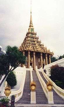
The provincial seal shows the temple Wat Phra Buddha Baat. In the 17th century a hunter found a puddle of water which looked like a large footprint. It was declared a footprint of Buddha, and a temple was built around it. Phra Phutthabat means footprint of Buddha.
The provincial tree is Lagerstroemia floribunda and the provincial flower is the yellow cotton tree (Cochlospermum regium).
Administrative divisions

The province is divided into 13 districts (amphoe). The districts are further subdivided into 111 communes (tambon) and 965 villages (muban).
Transport
Rail
Saraburi's main station is Saraburi Railway Station. There is a major rail junction at Kaeng Khoi Junction.
References
- ↑ "Population of the Kingdom" (PDF). Department of Provincial Affairs (DOPA) Thailand (in Thai). 2014-12-31. Retrieved 19 Mar 2015.
- ↑ Wipatayotin, Apinya (13 January 2018). "Saraburi area hits No.1 for worst air quality". Bangkok Post. Retrieved 26 July 2018.
External links

- Provincial page, Tourist Authority of Thailand
- Khao Yai National Park
- Saraburi history in Thai language Archived April 9, 2008, at the Wayback Machine.
Places adjacent to Saraburi Province | |
|---|---|
| Wikimedia Commons has media related to Saraburi. |
Coordinates: 14°31′42″N 100°54′35″E / 14.52833°N 100.90972°E