Yala Province
| Yala ยะลา | |||
|---|---|---|---|
| Province | |||
| |||
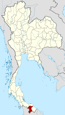 Map of Thailand highlighting Yala Province | |||
| Country | Thailand | ||
| Capital | Yala | ||
| Government | |||
| • Governor | Doldet Pattanarat (since October 2015) | ||
| Area | |||
| • Total | 4,521.1 km2 (1,745.6 sq mi) | ||
| Area rank | Ranked 48th | ||
| Population (2014) | |||
| • Total | 511,911 | ||
| • Rank | Ranked 59th | ||
| • Density | 110/km2 (290/sq mi) | ||
| • Density rank | Ranked 47th | ||
| HDI | |||
| • HDI (2009) | 0.687 (medium) (70th) | ||
| Time zone | UTC+7 (ICT) | ||
| Area code(s) | 073 | ||
| ISO 3166 code | TH-95 | ||
| Vehicle registration | ยะลา, เบตง (Betong) | ||


Yala (Thai: ยะลา, pronounced [já(ʔ).lāː]) is the southernmost province (changwat) of Thailand. Neighboring provinces are (from northwest clockwise) Songkhla, Pattani, and Narathiwat. Yala is one of two landlocked provinces in southern Thailand, the other being Phatthalung.[1] Its southern part borders Kedah and Perak of Malaysia.
Etymology
The name "Yala" is the Thai transliteration of "Jala" (Jawi: جال) and the original Sanskrit name means 'net'. The province is also known as "Jolor" (Jawi: جولور) in Patani Malay language.
Geography
Yala Province is in south Thailand. The highest point of the Sankalakhiri Range (Northern Titiwangsa Mountains), the 1,533 metres (5,030 ft)-high Ulu Titi Basah (ยูลูติติ บาซาห์), is on the Thai/Malaysian border between Yala Province and Perak.[2]
History
Historically, Pattani Province was the centre of the Sultanate of Patani, a semi-independent Malay kingdom that paid tribute to the Thai kingdoms of Sukhothai and Ayutthaya. After Ayutthaya fell under Burmese control in 1767, the Sultanate of Patani gained full independence, but under King Rama I (reigned from 1782 to 1809), the area was again placed under Siam's control in 1785 and made a mueang. In 1808, Mueang Pattani was split into seven smaller mueang including Yala and Reman.[3]
The province was recognized as part of Siam by the Anglo-Siamese Treaty of 1909, negotiated with the British Empire, while Siam surrendered its claims to Kelantan, Kedah, Terengganu, and Perlis.
There is a separatist movement in Yala, which after being dormant for many years, emerged again in 2004 and has become increasingly violent. Eight bombs exploded in the province over two days, on 6–7 April 2014. The bombings resulted in one death and 28 injuries, as well as damage to a warehouse estimated at 100 million baht. Local officials accordingly tightened security in the province during the Songkran festivities scheduled for 13–15 April.[4]
The British Foreign and Commonwealth Office (FCO) in 2014 advised its citizens to only undertake essential travel in the province, while the Australian Government's Department of Foreign Affairs and Trade recommends that travellers completely avoid the province.[5][6]
Demographics
Yala is one of the four provinces of Thailand with a Muslim majority. About 72 percent of the people are Malay-speaking Muslims and mainly live in rural locations. The remainder are Thai and Thai Chinese Buddhists, who live in towns and cities.
Symbols
The provincial seal shows a miner with simple mining tools including hoes, crowbars, and baskets. Yala was originally a mining town with tin and tungsten ores.
The provincial tree is the red saraca (Saraca declinata), and the provincial flower is the bullet wood (Mimusops elengi).
Administrative divisions
Yala is divided into eight districts (amphoe), which are further subdivided into 56 sub-districts (tambon) and 341 villages (muban).
| Map | Number | Name | Thai | Malay |
|---|---|---|---|---|
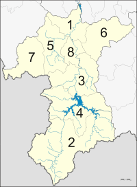 | ||||
| 1 | Mueang Yala | เมืองยะลา | Jala, Jolor | |
| 2 | Betong | เบตง | Betung | |
| 3 | Bannang Sata | บันนังสตา | Bendang Setar | |
| 4 | Than To | ธารโต | Air Kedung | |
| 5 | Yaha | ยะหา | Johar | |
| 6 | Raman | รามัน | Reman | |
| 7 | Kabang | กาบัง | Kabae, Kabe | |
| 8 | Krong Pinang | กรงปินัง | Kampung Pinang |
Transportation
The nearest airport in Yala is Hat Yai International Airport in Songkhla Province. As of 2018 Thailand's transport ministry is constructing the 1.9 billion baht Betong Airport. It is scheduled for completion in 2020.[7]
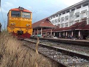
Yala is served by the State Railway of Thailand from the Yala Railway Station.
See also
References
- ↑ Lian Lim, Siew (2013). "The Role of Shadow Puppetry in the Development of Phatthalung Province, Thailand" (PDF). siewlianlim.com. Southeast Asia Club Conference, Northern Illinois University. Retrieved 27 August 2018.
- ↑ "Gunong Ulu Titi Basah: Thailand". Geographical Names. Information Technology Associates. 1995–2012. Retrieved 8 April 2014.
- ↑ "Welcome to Yala: Introduction". Sawadee.com. Retrieved 27 Apr 2015.
- ↑ "Four more bombs explode in Yala this morning". MCOT. 7 April 2014. Retrieved 8 April 2014.
- ↑ "Foreign travel advice Thailand". GOV.UK. Crown. 25 March 2014. Retrieved 8 April 2014.
- ↑ "Thailand". smartraveller.com.au. Australian Department of Foreign Affairs and Trade. 3 April 2014. Retrieved 8 April 2014.
- ↑ Sritama, Suchat (27 August 2018). "Better days around the bend". Bangkok Post. Retrieved 27 August 2018.
External links

- Province page from the Tourist Authority of Thailand
- (in Thai) Website of the Province
| Wikimedia Commons has media related to Yala Province. |
Places adjacent to Yala Province | ||||||||||
|---|---|---|---|---|---|---|---|---|---|---|
| ||||||||||
Coordinates: 6°32′24″N 101°16′52″E / 6.54000°N 101.28111°E