Din Daeng District
| Din Daeng ดินแดง | |
|---|---|
| District | |
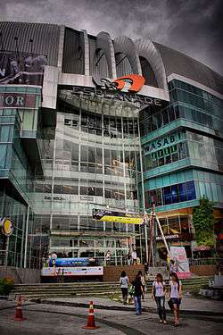 Esplanade at Ratchadaphisek Rd. | |
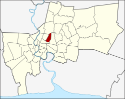 District location in Bangkok | |
| Coordinates: 13°46′11″N 100°33′10″E / 13.76972°N 100.55278°ECoordinates: 13°46′11″N 100°33′10″E / 13.76972°N 100.55278°E | |
| Country | Thailand |
| Province | Bangkok |
| Seat | Din Daeng |
| Khwaeng | 2 |
| Khet established | January 14, 1994 |
| Area | |
| • Total | 8.4 km2 (3.2 sq mi) |
| Population (2017) | |
| • Total | 122,563[1] |
| • Density | 14,590.83/km2 (37,790.1/sq mi) |
| Time zone | UTC+7 (ICT) |
| Postal code | 10400 |
| Geocode | 1026 |
Din Daeng (Thai: ดินแดง, pronounced [dīn dɛ̄ːŋ]) is one of the 50 districts (khet) of Bangkok, Thailand. Its neighbours, clockwise from north, are Chatuchak, Huai Khwang, Ratchathewi, and Phaya Thai.
History
The district was created in 1993, when the eastern part of Phaya Thai was split off to form a new district. The district is highly populated partly due to the concentration of apartments built by National Housing Authority. They are along Din Daeng Road and Pracha Songkhro Road.
Administration
The district is divided into two sub-districts (khwaeng).
| 1. | Din Daeng | ดินแดง |
| 2. | Ratchadaphisek | รัชดาภิเษก |
Transportation

The MRT passes along Din Daeng's eastern border (touching Huai Khwang) with five stations: Phra Ram 9, Thailand Cultural Centre, Huai Khwang, Sutthisan, and Ratchadaphisek.
References
- ↑ "Population and House Report for Year 2017 (see page 2 for data of this district)". Department of Provincial Administration, Ministry of Internal Affairs. Retrieved 2018-04-01. (Search page)
External links
.svg.png)
This article is issued from
Wikipedia.
The text is licensed under Creative Commons - Attribution - Sharealike.
Additional terms may apply for the media files.