Pattani Province
| Pattani ปัตตานี | |||
|---|---|---|---|
| Province | |||
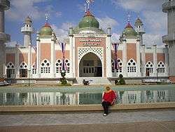 Pattani Grand Mosque | |||
| |||
 Map of Thailand highlighting Pattani Province | |||
| Country | Thailand | ||
| Capital | Pattani | ||
| Government | |||
| • Governor | Wiranan Phengchan (since October 2016) | ||
| Area | |||
| • Total | 1,940.4 km2 (749.2 sq mi) | ||
| Area rank | Ranked 67th | ||
| Population (2014) | |||
| • Total | 686,186 | ||
| • Rank | Ranked 39th | ||
| • Density | 350/km2 (920/sq mi) | ||
| • Density rank | Ranked 9th | ||
| Time zone | UTC+7 (ICT) | ||
| ISO 3166 code | TH-94 | ||


Pattani (Thai: ปัตตานี, pronounced [pàt.tāː.nīː]) is one of the southern provinces (changwat) of Thailand. Neighboring provinces are (from southeast clockwise) Narathiwat, Yala, and Songkhla.
History
The name Pattani is the Thai adaptation of the Malay name Patani (Jawi: ڤتاني), which can mean "this beach" in Patani Malay language. (In standard Malay, this would be pantai ini.) Another suggestion is that it derives from a Sanskrit word pathini, meaning "virgin nymph"; Pathini was the name of a daughter of Merong Mahawangsa, founder of the preceding Langkasuka Empire.[1]
Historically, Pattani Province was the centre of the Malay Sultanate of Patani Darul Makrif. For centuries a tributary state of Siam, Pattani has been governed by Siam since its conquest in 1785. Siamese rule was officially acknowledged by the Anglo-Siamese Treaty of 1909 negotiated with the British Empire. Both Yala (Jala) and Narathiwat (Menara) were originally part of Patani, but were made provinces of their own during the territorial administrative reform and the creation of a united centralized Siam state.
Demographics
Pattani is one of the four provinces of Thailand where the majority of the population are Malay Muslim. They make up about 88 percent of its population. The people speak the Patani Malay language, although most also speak Thai.
Geography
Pattani is on the Malay Peninsula, with the coast of the Gulf of Thailand to the north. The south is dominated by the Sankalakhiri mountain range, which includes Budo-Su-ngai Padi National Park, on the border with Yala and Narathiwat.
Symbols
The seal of the province shows the cannon called Phraya Tani, known as Sri Pattani in Malay, which was cast in Pattani Province. It was brought to Bangkok in 1785, and is now on display in front of the Ministry of Defence in Bangkok.
The provincial flower is the Chinese hibiscus (Hibiscus rosa-sinensis), and the provincial tree the Ironwood (Hopea odorata).
Administrative divisions
Pattani is divided into 12 districts (amphoe), which are further subdivided into 115 communes (tambon) and 629 villages (muban).
The districts of Chana (Malay: Chenok), Thepa (Malay:Tiba) and Saba Yoi (Malay:Sebayu) were detached from Pattani and transferred to Songkhla in 1796 by Siam government.
| Map | Number | Name | Thai | Jawi | Malay |
|---|---|---|---|---|---|
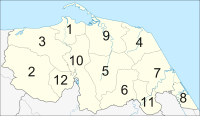 | |||||
| 1 | Mueang Pattani | เมืองปัตตานี | فطاني | Patani | |
| 2 | Khok Pho | โคกโพธิ์ | كوكفور | Kuk Pur | |
| 3 | Nong Chik | หนองจิก | نونغجيك | Nung Chik | |
| 4 | Panare | ปะนาเระ | فناريق | Penarik | |
| 5 | Mayo | มายอ | مايو | Mayu | |
| 6 | Thung Yang Daeng | ทุ่งยางแดง | |||
| 7 | Sai Buri | สายบุรี | سليندونغ بايو ، تلوبن | Selindung Bayu, Teluban | |
| 8 | Mai Kaen | ไม้แก่น | |||
| 9 | Yaring | ยะหริ่ง | جمبو | Jambu, | |
| 10 | Yarang | ยะรัง | يا ليمو | Ya Li hu | |
| 11 | Kapho | กะพ้อ | |||
| 12 | Mae Lan | แม่ลาน |
Military rule
As of 2018, the provisions of Thailand's Internal Security Act remain imposed on Mae Lan District. Internal security restrictions, maintained by Thailand's Internal Security Operations Command (ISOC) can result in curfews, prohibited entry, or prohibited transport of goods. It is considered one step below the imposition of full martial law.[2]
Transport
Air
Pattani is served by Pattani Airport, but the airport does not allow public flights due to the Royal Thai Air Force's reliance on it for counter-insurgency operations in the area.
Rail
Pattani's main station is Pattani Railway Station.
See also
References
- ↑ "{ms} Sejarah Malaysia - Asal Usul nama Sungai Petani". Sejarahmalaysia.pnm.my. Archived from the original on 2013-06-03. Retrieved 2012-08-24.
- ↑ Raksaseri, Kornchanok (8 January 2018). "Isoc power boost 'not political'". Bangkok Post. Retrieved 8 January 2018.
External links

- Pattani province website (Thai)
- Tourism Authority of Thailand (TAT): Pattani
- Pattani Erupts Archived February 13, 2009, at the Wayback Machine.
- Thailand Islamic Insurgency
- Muslim rebels light fuse in Thailand
| Wikimedia Commons has media related to Pattani Province. |
Places adjacent to Pattani Province | ||||||||||
|---|---|---|---|---|---|---|---|---|---|---|
| ||||||||||