Satun Province
| Satun สตูล | |||
|---|---|---|---|
| Province | |||
 | |||
| |||
 Map of Thailand highlighting Satun Province | |||
| Country | Thailand | ||
| Capital | Satun | ||
| Government | |||
| • Governor | Phatthraphon Rattanaphichetchai (since October 2015) | ||
| Area | |||
| • Total | 2,479 km2 (957 sq mi) | ||
| Area rank | Ranked 63rd | ||
| Population (2014) | |||
| • Total | 312,673 | ||
| • Rank | Ranked 69th | ||
| • Density | 130/km2 (330/sq mi) | ||
| • Density rank | Ranked 45th | ||
| Time zone | UTC+7 (ICT) | ||
| ISO 3166 code | TH-91 | ||
Satun (Thai: สตูล, pronounced [sā.tūːn]; Malay: Setul) is one of the southern provinces (changwat) of Thailand. Neighboring provinces are (from north clockwise) Trang, Phatthalung, and Songkhla. To the south it borders Perlis of Malaysia.
Etymology
The name Satun is a Thai version of its original Malay name, Setul (santol, or wild mangosteen tree).
Geography
The province is on the Malay Peninsula, on the shore of the Andaman Sea. It is separated from Songkhla Province by the Nakhon Si Thammarat mountain range, and from Malaysia by the Sankalakhiri mountains.
The Ko Tarutao and Ko Phetra marine national parks are part of the province. Close to the border with Malaysia is the Thale Ban National Park, a big freshwater swamp area.
History
Until 1916 Satun was a small Malay state known as Kingdom of Setul Mambang Segara, closely related to Kedah Sultanate. After that date it was administered by a governor sent from Nakhon Si Thammarat. In 1897 Satun became part of Monthon Syburi (now Kedah), which in 1909 was divided between British Empire and Siam as part of Anglo-Siamese Treaty of 1909. While most of Kedah was ceded to Britain, Satun was awarded to Siam because it had a relatively large Thai population. Satun was then incorporated into Monthon Phuket. The monthon system was ended in 1933, and Satun Province became a first-level subdivision of Thailand.
The province was to have been the site of the Pak Bara Deep-seaport in La-ngu District.
Demographics
Satun is one of the four provinces of Thailand which have a Muslim majority: 67.8 percent are Muslim and 31.9 percent are Buddhists. Most of the Muslims have some ethnic-Malay ancestry, though only 9.9 percent of the population claims to be ethnically Malay. Majority language in Satun Province is Southern Thai, while the Malay dialect used in Satun is distinctly different from Patani Malay and is much closer to the Kedah dialect of Malay.[1]
Since Satun had belonged to the Kedah Sultanate, which had a strong relationship for many centuries with both Ayutthaya and Siam under the Chakri dynasty, its Malay Muslims commonly intermarry with Thai Buddhists without serious religious hesitation. This custom has created a distinct social group known as samsam, meaning a mixed person. Most samsams, if not all, are Muslims.[2]
Unlike the other Muslim majority provinces in Thailand, Satun does not have a history of political confrontation with the central power in Bangkok or of tension with the Buddhist population which makes up the majority of Thailand as a country.[3] Malay Muslims in Satun are substantially assimilated and rarely sympathise with separatism from Thailand, in contrast to the Malay Muslims in Pattani, Narathiwat, and Yala.
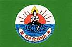
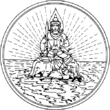
Symbols
The provincial seal shows Pra Samut Thewaa sitting on a rock in the sea, with the sunset behind. Pra Samut Thewaa is a spirit who guards the sea. The rock is his divine vehicle. The sunset symbolizes the Andaman Sea, which lies to the west of the province.
The provincial tree is the Thai Rosewood or Pha-yungklaep (Dalbergia bariensis), and the provincial flower is the Snowy Orchid Tree (Bauhinia acuminata). The province's motto is Peaceful, clean, and pure nature.
Administrative divisions
Satun is divided into seven districts (amphoe). These are further subdivided into 36 sub-districts (tambon) and 277 villages (muban). Satun itself is the only town (thesaban mueang), there are a further five townships (thesaban tambon). The non-municipal area is administered by 35 tambon administrative organizations (TAO).
| Map | Number | Name | Thai | Malay |
|---|---|---|---|---|
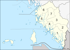 | ||||
| 1 | Mueang Satun | เมืองสตูล | Mambang | |
| 2 | Khuan Don | ควนโดน | Dusun | |
| 3 | Khuan Kalong | ควนกาหลง | Padang Kecil | |
| 4 | Tha Phae | ท่าแพ | Berakit | |
| 5 | La-ngu | ละงู | Laut | |
| 6 | Thung Wa | ทุ่งหว้า | Sungai Upe | |
| 7 | Manang | มะนัง |
Originally, the province was divided into two districts, Mambang and Thung Wa, and the minor district (king amphoe) La-ngu. Due to the decline of pepper production in Thung Wa District, in 1930 the government made Thung Wa a minor district and instead declared La-ngu a district. In 1939 Mambang was renamed to Mueang Satun. Khuan Kalong was split off from Mueang district in 1969, from which in turn Tha Pae was split in 1976 and Manang in 1996. In 1973 Thung Wa regained district status. Khuan Don was established in 1975 by splitting it from Mueang district.
Transportation
Boat
Satun is connected to Malaysian Langkawi Island by direct ferry service.
Economy
According to a Satun Provincial Office spokesman, the province's tourism income rose from two to 6.3 billion baht from 2010 to 2013, while tourist arrivals increased from 690,000 to 1.13 million.[4]
The Department of Airports announced in October 2018 that it will conduct a feasibility study of an airport in the province. Six million baht is allocated for the study, to be completed in September 2019.[5]
References
- ↑ Institute of South East Asian Studies (1988). The South East Asian Review. Institute of South East Asian Studies. p. 15.
- ↑ Andrew D.W. Forbes (1988). The Muslims of Thailand. Soma Prakasan. p. 12. ISBN 974-9553-75-6.
- ↑ Moshe Yegar, Between Integration and Secession
- ↑ Wangkiat, Paritta (2015-04-25). "Satun residents stage more port protests". Bangkok Post. Retrieved 26 Apr 2015.
- ↑ "Satun Airport coming?". Bangkok Post (Life, Travel). 11 October 2018. p. 4.
External links

- Website of the province Archived July 24, 2012, at the Wayback Machine.
| Wikimedia Commons has media related to Satun. |
Places adjacent to Satun Province | ||||||||||
|---|---|---|---|---|---|---|---|---|---|---|
| ||||||||||
Coordinates: 6°37′26″N 100°04′01″E / 6.62389°N 100.06694°E