Lopburi Province
| Lopburi ลพบุรี | |||
|---|---|---|---|
| Province | |||
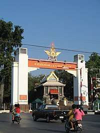 Lopburi City Gate, from old to new city | |||
| |||
 Map of Thailand highlighting Lop Buri Province | |||
| Country | Thailand | ||
| Capital | Lopburi | ||
| Government | |||
| • Governor | Phanu Yaemsi (since October 2015) | ||
| Area | |||
| • Total | 6,199.8 km2 (2,393.8 sq mi) | ||
| Area rank | Ranked 37th | ||
| Population (2014) | |||
| • Total | 758,406 | ||
| • Rank | Ranked 30th | ||
| • Density | 120/km2 (320/sq mi) | ||
| • Density rank | Ranked 38th | ||
| HDI | |||
| • HDI (2009) | 0.742 (35th) | ||
| Time zone | UTC+7 (ICT) | ||
| Area code(s) | 036 | ||
| ISO 3166 code | TH-16 | ||
| Vehicle registration | ลพบุรี | ||

Lopburi (Thai: ลพบุรี, RTGS: Lop Buri,[1] pronounced [lóp bū.rīː]) is a province in the central region of Thailand. The province is divided into 11 administrative districts, and Mueang Lopburi District is the capital. With over 750,000 people, the province is Thailand's 37th largest area and 38th most populous. There are eight neighboring provinces, Phetchabun, Chaiyaphum, Nakhon Ratchasima, Saraburi, Phranakhon Si Ayutthaya, Ang Thong, Sing Buri, and Nakhon Sawan.
Lopburi is a significant province historically, where many historical structures, artifacts, and prehistoric settlements have been discovered. In the past, Lopburi was called by the name Lavo, that is, the kingdom had been ruled by an absolute monarch.
History
Known as Lavo during much of its history, Lopburi probably dates to prehistoric times.[2] The name Lavo originated in the Dvaravati period (6th–11th century CE). The conquering Khmer would build many impressive temples in the city during its rule. Lopburi may even have liberated itself for a time, as it sent independent embassies to China in 1115 and 1155. In 1289 it sent another embassy to China, but soon became part of the Thai kingdom of Sukhothai and later Ayutthaya.
During the Ayutthaya period, King Ramathibodi I sent Phra Ramesuan (later King Ramesuan) as the Uparaja to reign in Lopburi. In 1665 King Narai the Great ordered a new palace built on the east bank of the Lopburi River and made Lopburi the second capital of the country, as Ayutthaya was threatened by the Dutch. After King Narai died, the city was almost abandoned and fell into ruin.
In 1856 King Mongkut of the Chakri dynasty ordered King Narai's palace to be renovated. The city finally regained its importance in 1938, when Field Marshal Plaek Phibunsongkhram chose Lopburi to be the largest military base in Thailand.
Geography
Lopburi is on the east side of the Chao Phraya River valley, between the Lopburi River and Pa Sak Rivers. Thirty percent of the area of the province, including most of Tha Wung district, the southwestern parts of Mueang Lopburi and Ban Mi districts are a very low alluvial plain. The other 70 percent is mixed plains and hills, with the Phetchabun Mountains forming the eastern boundary of the province towards the Khorat Plateau.
Symbols
The provincial seal shows Vishnu in front of the Khmer temple Phra Prang Sam Yod.[3]
The escutcheon of Lopburi shows Phra Narai and in the background Phra Prang Sam Yod, the "Sanctuary with the Three Towers". It refers to King Narai who in 1664 fortified the city to be used as an alternative capital when Ayutthaya was threatened by a Dutch naval blockade.[4]
The provincial tree as well as the provincial flower is the bullet wood.[5]
The slogan of the province is National treasures of King Narai's palace and Phra Kan Shrine, famous Prang Sam Yot, city of Din So Phong Marl, well-known Pa Sak Cholasit Dam and golden land of King Narai the Great.
Administrative divisions

The province is subdivided into 11 districts (amphoe). The districts are further subdivided into 124 sub-districts (tambon) and 1,110 villages (muban).
Transportation
Roads
The main road through Lobpuri is Route 1 (Phahonyothin Road), which starts in Bangkok, and continues through Lopburi, Chai Nat, Nakhon Sawan, Kamphaeng Phet, Tak, Lampang, Chiang Rai, and the border with Burma at Mae Sai. Route 311 leads west to Sing Buri, and Route 3196 leads south-west to Ang Thong.
Rail

Lopburi is a station of the State Railway of Thailand's Northern Line Lopburi Railway Station, forming the end of Bangkok's suburban service.
Air
Lopburi is served by the Khok Kathiam Air Force Base but in military usage not public, 9 kilometres (5.6 mi) north of the town.
Education
- Thepsatri Rajabhat University
- Kasetsart University, Lopburi Campus
- Ramkhamhaeng University, Lopburi Campus
References
- ↑ ประกาศราชบัณฑิตยสถาน เรื่อง การเขียนชื่อจังหวัด เขต อำเภอ และกิ่งอำเภอ (PDF). Royal Gazette (in Thai). 117 (พิเศษ 94 ง): 2. 14 Sep 2000.
- ↑ "Lopburi". Tourist Authority of Thailand (TAT). Retrieved 21 June 2015.
- ↑ "Phra Prang Sam Yot". Tourism Authority of Thailand (TAT). Retrieved 2015-11-02.
- ↑ "Provincial Escutcheon". THAILEX Travel Encyclopedia. Retrieved 2015-11-02.
- ↑ "Lopburi Province (จังหวัดลพบุรี)". Lopburi Province. Retrieved 2015-11-02.
External links
| Wikimedia Commons has media related to Lopburi Province. |
- Website of province (Thai)
- Lopburi provincial map, coat of arms and postal stamp Archived June 21, 2015, at the Wayback Machine.
Places adjacent to Lopburi Province | |
|---|---|
Lopburi | ||
|---|---|---|
| Main article | 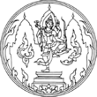 | |
| Capital | ||
| Districts (amphoe) | ||
| Royalty | ||
| Related topics | ||
| Neighboring areas | ||
Coordinates: 14°48′2″N 100°39′5″E / 14.80056°N 100.65139°E