Surat Thani
| Surat Thani สุราษฎร์ธานี | ||
|---|---|---|
| City Municipality | ||
|
City of Surat Thani เทศบาลนครสุราษฎร์ธานี | ||
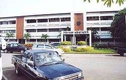 Municipal office | ||
| ||
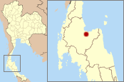 Location of Surat Thani | ||
 Surat Thani Location in Thailand | ||
| Coordinates: 9°8′23″N 99°19′50″E / 9.13972°N 99.33056°E | ||
| Country | Thailand | |
| Province | Surat Thani | |
| District | Mueang Surat Thani | |
| Government | ||
| • Mayor | Theerakit Wangmuthitakul | |
| Area | ||
| • Total | 68.97 km2 (26.63 sq mi) | |
| Elevation | 10 m (30 ft) | |
| Population (2015) | ||
| • Total | 129,500 | |
| • Density | 187,763/km2 (486,300/sq mi) | |
| Time zone | UTC+7 (ICT) | |
| Area code | (+66) 77 | |
| Website |
suratcity | |

Surat Thani (Thai: สุราษฎร์ธานี, pronounced [sù.râːt tʰāː.nīː]) is a city in Amphoe Mueang Surat Thani, Surat Thani Province, southern Thailand. It lies 651 km south of Bangkok. It is the capital of Surat Thani Province. The city has a population of 128,179 (2009), and an area of 68.97 square kilometers. The city's population density is 1,858.47 inhabitants per km².
Surat Thani is near the mouth of the Tapi River on the Gulf of Thailand. The city offers no major tourist attractions in itself, and is mainly known to tourists as the jumping-off point to Ko Samui, Ko Tao, and Ko Pha Ngan. It is the regional commercial center, with a seaport dealing in the main products of the province, rubber and coconuts.
History
The city received its name, which means "city of good people", by King Vajiravudh (Rama VI) in 1915. The name was given to the city due to the intense devotion of the locals to Buddhism. Previously the city was known as Bandon, meaning "village on higher ground". The name of the city is taken from the Indian city Surat in Gujarat on the Indian River Tapi. King Vajiravudh (Rama VI) gave this name to his city as he was impressed with the Indian city.
On 21 December 1930 Surat Thani became a sanitary district (sukhaphiban),[1] which was upgraded to a town (thesaban mueang) on 7 December 1935, with a municipal area of 2.67 km².[2] The area of the municipality was enlarged to 6.95 km² on 14 October 1958,[3] and on 22 December 1994 it was further enlarged to 68.97 km².[4] On 4 May 2007, the town was upgraded to city status (thesaban nakhon).[5]
Since 1969 Surat Thani is the seat of the Roman Catholic Diocese of Surat Thani, responsible for about 6,000 Catholics in southern Thailand.
Climate
Surat Thani has a tropical savanna climate (Köppen climate classification Aw). Temperatures are fairly stable throughout the year, although the pre-monsoon months (March–May) are somewhat hotter. There is a short dry season from January to April, followed by the wet season that lasts from May to December. The heaviest rains occur in October and November.
| Climate data for Surat Thani (1981–2010) | |||||||||||||
|---|---|---|---|---|---|---|---|---|---|---|---|---|---|
| Month | Jan | Feb | Mar | Apr | May | Jun | Jul | Aug | Sep | Oct | Nov | Dec | Year |
| Record high °C (°F) | 35.0 (95) |
36.6 (97.9) |
38.8 (101.8) |
39.7 (103.5) |
39.8 (103.6) |
36.8 (98.2) |
36.4 (97.5) |
36.6 (97.9) |
35.8 (96.4) |
35.7 (96.3) |
36.3 (97.3) |
35.0 (95) |
39.8 (103.6) |
| Average high °C (°F) | 31.1 (88) |
32.7 (90.9) |
34.2 (93.6) |
35.0 (95) |
34.0 (93.2) |
33.4 (92.1) |
32.9 (91.2) |
32.7 (90.9) |
32.4 (90.3) |
31.6 (88.9) |
30.3 (86.5) |
29.9 (85.8) |
32.5 (90.5) |
| Daily mean °C (°F) | 25.6 (78.1) |
26.4 (79.5) |
27.5 (81.5) |
28.3 (82.9) |
27.7 (81.9) |
27.6 (81.7) |
27.1 (80.8) |
27.0 (80.6) |
26.7 (80.1) |
26.4 (79.5) |
26.0 (78.8) |
25.5 (77.9) |
26.8 (80.2) |
| Average low °C (°F) | 21.1 (70) |
21.1 (70) |
21.9 (71.4) |
23.4 (74.1) |
23.8 (74.8) |
23.7 (74.7) |
23.3 (73.9) |
23.4 (74.1) |
23.2 (73.8) |
23.1 (73.6) |
22.9 (73.2) |
22.0 (71.6) |
22.7 (72.9) |
| Record low °C (°F) | 16.5 (61.7) |
16.2 (61.2) |
17.0 (62.6) |
20.0 (68) |
20.7 (69.3) |
20.5 (68.9) |
20.5 (68.9) |
20.2 (68.4) |
19.7 (67.5) |
19.5 (67.1) |
18.5 (65.3) |
17.6 (63.7) |
16.2 (61.2) |
| Average rainfall mm (inches) | 36.8 (1.449) |
12.3 (0.484) |
24.0 (0.945) |
73.4 (2.89) |
178.0 (7.008) |
125.0 (4.921) |
148.8 (5.858) |
139.6 (5.496) |
188.4 (7.417) |
236.4 (9.307) |
329.9 (12.988) |
129.4 (5.094) |
1,622 (63.858) |
| Average rainy days | 5.4 | 2.0 | 3.4 | 7.6 | 17.2 | 14.6 | 16.5 | 16.4 | 19.1 | 18.6 | 17.4 | 12.0 | 150.2 |
| Average relative humidity (%) | 81 | 77 | 75 | 77 | 82 | 81 | 82 | 82 | 84 | 87 | 87 | 84 | 82 |
| Mean monthly sunshine hours | 198.4 | 214.7 | 201.5 | 183.0 | 155.0 | 114.0 | 114.7 | 114.7 | 108.0 | 108.5 | 138.0 | 176.7 | 1,827.2 |
| Mean daily sunshine hours | 6.4 | 7.6 | 6.5 | 6.1 | 5.0 | 3.8 | 3.7 | 3.7 | 3.6 | 3.5 | 4.6 | 5.7 | 5.0 |
| Source #1: Thai Meteorological Department[6] | |||||||||||||
| Source #2: Office of Water Management and Hydrology, Royal Irrigation Department (sun and humidity)[7] | |||||||||||||
Transportation
Rail
Surat Thani is connected with Bangkok by the Southern Line of the State Railway of Thailand. Surat Thani Railway Station is the main station of the province. It is in Phunphin, about 15 kilometres (9.3 mi) from Surat Thani.
Road
Surat Thani is connected to Nakhon Si Thammarat by Route 401. Asian highway AH2 also passes the city at Phunphin.
Air
Surat Thani International Airport is about 30 kilometres (19 mi) from the city by road.[8]
Water
Some ferries depart from the city centre port. The main ferry pier is at Don Sak, 58 km east of Surat Thani.
Administration
Surat Thani covers tambon Talad and Bang Kung, and parts of tambons Khlong Chanak, Bang Chana, Bang Baimai, Makham Tia, and all of Mueang Surat Thani District. The city is divided into 45 communities (chumchon).
References
- ↑ พระบรมราชโองการ ประกาศ ใช้พระราชบัญญัติจัดการสุขาภิบาล จังหวัดสุราษฎร์ธานี มณฑลนครศรีธรรมราช (PDF). Royal Gazette (in Thai). 47 (ก): 271–273. December 21, 1930.
- ↑ พระราชกฤษฎีกาจัดตั้งเทศบาลเมืองสุราษฎร์ธานี จังหวัดสุราษฎร์ธานี พุทธศักราช ๒๔๗๘ (PDF). Royal Gazette (in Thai). 51 (ก): 1758–1762. December 10, 1935.
- ↑ พระราชกฤษฎีกาเปลี่ยนแปลงเขตเทศบาลเมืองสุราษฎร์ธานี จังหวัดสุราษฎร์ธานี พ.ศ. ๒๕๐๑ (PDF). Royal Gazette (in Thai). 75 (79 ก): 555–558. October 14, 1958.
- ↑ พระราชกฤษฎีกาเปลี่ยนแปลงเขตเทศบาลเมืองสุราษฎร์ธานี จังหวัดสุราษฎร์ธานี (ฉบับที่ ๒) พ.ศ. ๒๕๓๗ (PDF). Royal Gazette (in Thai). 111 (59 ก): 29–32. December 21, 1994.
- ↑ ประกาศกระทรวงมหาดไทย เรื่อง เปลี่ยนแปลงฐานะเทศบาลเมืองสุราษฎร์ธานี อำเภอเมืองสุราษฎร์ธานี จังหวัดสุราษฎร์ธานี เป็นเทศบาลนครสุราษฎร์ธานี (PDF). Royal Gazette (in Thai). 124 (Special 67 ง): 15. June 4, 2007.
- ↑ "Climatological Data for the Period 1981–2010". Thai Meteorological Department. p. 23. Retrieved 7 August 2016.
- ↑ "ปริมาณการใช้น้ำของพืชอ้างอิงโดยวิธีของ Penman Monteith (Reference Crop Evapotranspiration by Penman Monteith)" (PDF) (in Thai). Office of Water Management and Hydrology, Royal Irrigation Department. p. 106. Retrieved 7 August 2016.
- ↑ "Surat Thani Airport". OurAirports. Retrieved 6 February 2013.
External links
| Wikimedia Commons has media related to Surat Thani. |
- Surat Thani City Website (Thai only)

Coordinates: 9°8′23″N 99°19′50″E / 9.13972°N 99.33056°E
| ||