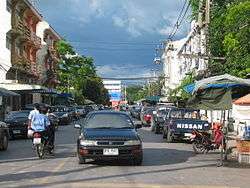
Nakhon Nayok Province
| Nakhon Nayok นครนายก | |||
|---|---|---|---|
| Province | |||
 | |||
| |||
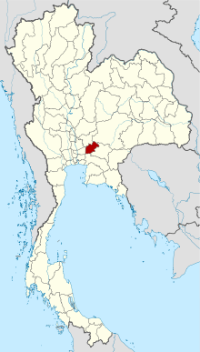 Map of Thailand highlighting Nakhon Nayok Province | |||
| Country | Thailand | ||
| Capital | Nakhon Nayok City | ||
| Government | |||
| • Governor | Pradit Yamanan (since October 2016) | ||
| Area | |||
| • Total | 2,122 km2 (819 sq mi) | ||
| Area rank | Ranked 66th | ||
| Population (2014) | |||
| • Total | 257,300 | ||
| • Rank | Ranked 70th | ||
| • Density | 120/km2 (310/sq mi) | ||
| • Density rank | Ranked 41st | ||
| Time zone | UTC+7 (ICT) | ||
| ISO 3166 code | TH-26 | ||

Nakhon Nayok (Thai: นครนายก, pronounced [ná(ʔ).kʰɔ̄ːn nāː.jók]) is one of the central provinces (changwat) of Thailand, established by the Act Establishing Changwat Samut Prakan, Changwat Nonthaburi, Changwat Samut Sakhon, and Changwat Nakhon Nayok, Buddhist Era 2489 (1946), which came into force as of 9 March 1946.
Neighboring provinces are (from north clockwise) Saraburi, Nakhon Ratchasima, Prachinburi, Chachoengsao, and Pathum Thani.
Nakhon Nayok is known for its refreshing waterfalls and abundant varieties of fruits.
Etymology
The word "nakhon" originates from the Sanskrit word "nagara" (Devanagari: नगर) meaning "city", and the word "nayok" is thought to have been derived from the Sanskrit "nāyaka" (Devanagari: नायक) meaning "leader" or "captain". However, in this connection, "na" means '[tax of] rice field' and "yok" means 'exempted'. Hence the name of the province literally means 'tax-free city'.[1]
Geography
The northern part of the province is in the Sankamphaeng Range, the southern prolongation of the Dong Phaya Yen mountains, with the highest elevation the 1,292 meter high Yod Khao Kiew. Most of that area is covered by the Khao Yai National Park. The central part of the province however is a rather flat river plain formed by the Nakhon Nayok River. The southern part of the province has relatively infertile acidic soil.
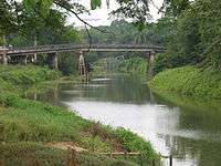
The main river of the province is the Nakhon Nayok River. It joins the Prachinburi River at Pak Nam Yothaka in Ban Sang District, Prachinburi Province, which then becomes the Bang Pa Kong River.
Wang Takhrai is a botanical garden belonging to the Chumphot - Phanthip Foundation. At the Wang Takhrai waterfall, it is a popular place for tourists to visit. Several other waterfalls within the province are well known tourist destinations: Nangrong and the nine-leveled Sarika waterfall are in Khao Yai National Park, as is the Lan Rak (or Tat Hin Kong) waterfall.
History
The city of Nakhon Nayok dates back to the Dvaravati Kingdom, probably founded in the 11th century. Ruins from this time are visible at Mueang Boran Dong Lakhon south of the modern city. Originally named Mueang Lablae, the name Nakhon Nayok was assigned to it in 1350, when it became a garrison town of the Ayutthaya kingdom protecting the eastern boundary.
On 1 January 1943 the government downgraded Nakhon Nayok Province and combined it with Prachinburi Province, except for Ban Na District which became part of Saraburi Province.[2] On 9 May 1946 the province was re-established.[3]
Symbols
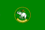
The provincial seal shows an elephant holding an ear of rice with its trunk. This symbolizes fertile rice fields, as well as the forests with numerous elephants. In the background two piles of straw, trees, and clouds symbolizing the natural beauty of the province.
The provincial flower and tree is the silk cotton tree (Cochlospermum religiosum).
Administrative divisions
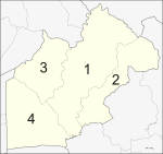
The province is divided into four districts (amphoe). The districts are further subdivided into 41 sub-districts (tambon) and 403 villages (muban).
References
- ↑ ประวัติจังหวัดนครนายก (in Thai). จังหวัดนครนายก. Archived from the original on 2009-02-09. Retrieved 2008-03-07.
- ↑ พระราชบัญญัติยุบและรวมการปกครองบางจังหวัด พุทธศักราช ๒๔๘๕ (PDF). Royal Gazette (in Thai). 59 (77 ก): 2447–2449. 10 Dec 1942.
- ↑ พระราชบัญญัติจัดตั้งจังหวัดสมุทรปราการ จังหวัดนนทบุรี จังหวัดสมุทรสาคร และจังหวัดนครนายก พุทธศักราช ๒๔๘๙ (PDF). Royal Gazette (in Thai). 63 (29 ก): 315–317. 9 May 1946.
External links

- News and Information in Nakhon Nayok (thai)
- Nakhon Nayok, Tourist Authority of Thailand
- Website of province (Thai)
- Khao Yai National Park
Places adjacent to Nakhon Nayok Province | |
|---|---|
Coordinates: 14°12′44″N 101°12′06″E / 14.21222°N 101.20167°E