Sai Mun District
| Sai Mun ทรายมูล | |
|---|---|
| District | |
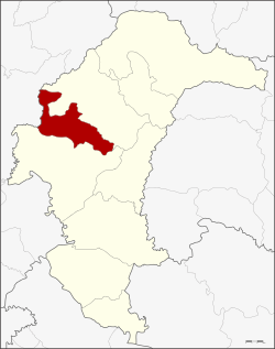 District location in Yasothon Province | |
| Coordinates: 15°56′22″N 104°12′32″E / 15.93944°N 104.20889°ECoordinates: 15°56′22″N 104°12′32″E / 15.93944°N 104.20889°E | |
| Country | Thailand |
| Province | Yasothon |
| Seat | Sai Mun |
| Area | |
| • Total | 272.8 km2 (105.3 sq mi) |
| Population (2005) | |
| • Total | 31,092 |
| • Density | 114.0/km2 (295/sq mi) |
| Time zone | UTC+7 (ICT) |
| Postal code | 35170 |
| Geocode | 3502 |
Sai Mun (Thai: ทรายมูล, pronounced [sāːj mūːn]) is a district of Yasothon Province in northeastern Thailand.
History
Sai Mun village was formerly a village of Yasothon District, when it was still part of Ubon Ratchathani Province. The village changed locations around the time of King Rama V when an epidemic caused villagers to abandon their homes and start a new village two kilometers away. At the site of their new village, which is present-day Sai Mun village, the villagers brought sand and soil from various sacred and revered places, and scattered it around the perimeter of their new home, to drive off the epidemic. It was from this ceremony that the village received its name.
Later, Sai Mun was given tambon status, and in 1968, Sanitary District (khet sukhaphiban) Sai Mun was created.[1]
After the separation of Yasothon from Ubon in 1972, on 15 May 1975, Sai Mun was elevated to a minor district (king amphoe), taking four tambons from Mueang Yasothon District: Sai Mun, Du Lat, Dong Mafai, and Na Wiang.[2]
In 1978, tambon Phai was reassigned from Kut Chum District to King Amphoe Sai Mun.[3]
On 26 July 1984, the minor district was elevated to a district,[4] and on 25 May 1999 Sanitary District Sai Mun was elevated to township (thesaban tambon) status.
Geography
Neighboring districts are (from the northeast clockwise) Kut Chum and Mueang Yasothon of Yasothon Province, and Selaphum of Roi Et Province.
Administration
The district is divided into five sub-districts (tambons) of 53 villages (muban).
| No. | Name | Thai name | Villages | Pop. |
|---|---|---|---|---|
| 1. | Sai Mun | ทรายมูล | 16 | 4,890 |
| 2. | Du Lat | ดู่ลาด | 12 | 4,426 |
| 3. | Dong Mafai | ดงมะไฟ | 9 | 5,740 |
| 4. | Na Wiang | นาเวียง | 7 | 3,958 |
| 5. | Phai | ไผ่ | 9 | 5,900 |
Education
Primary schools
As of 2003, Sai Mun had 25 primary schools with 2,737 students.
Secondary schools
As of 2003, Sai Mun had two secondary schools with 1,724 students:
- Sai Mun Witthaya School (โรงเรียนทรายมูลวิทยา)
- Dong Mafai Phitthayakhom School (โรงเรียนดงมะไฟพิทยาคม)
Religion
Sai Mun is predominantly Buddhist, and is home to 34 wats, with 145 monks and 134 novices.
References
- ↑ ประกาศกระทรวงมหาดไทย เรื่อง จัดตั้งสุขาภิบาลทรายมูล อำเภอยโสธร จังหวัดอุบลราชธานี (PDF). Royal Gazette (in Thai). 84 (125 ง): 3319–3320. December 26, 1967.
- ↑ ประกาศกระทรวงมหาดไทย เรื่อง แบ่งท้องที่อำเภอเมืองยโสธร จังหวัดยโสธร ตั้งเป็นกิ่งอำเภอทรายมูล (PDF). Royal Gazette (in Thai). 92 (89 ง): 1143. May 6, 1975.
- ↑ พระราชกฤษฎีกาเปลี่ยนแปลงเขตอำเภอกุดชุม กับกิ่งอำเภอทรายมูล อำเภอเมืองยโสธร จังหวัดยโสธร พ.ศ. ๒๕๒๑ (PDF). Royal Gazette (in Thai). 95 (73 ก special): 90. July 21, 1978.
- ↑ พระราชกฤษฎีกาตั้งอำเภอลานกระบือ อำเภอดงหลวง อำเภอทรายมูล อำเภอแม่เมาะ และอำเภอบัวเชด พ.ศ. ๒๕๒๗ (PDF). Royal Gazette (in Thai). 101 (96 ก special): 10–12. July 16, 1984.