Tha Bo District
| Tha Bo ท่าบ่อ | |
|---|---|
| Amphoe | |
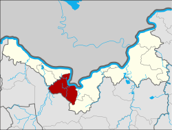 Amphoe location in Nong Khai Province | |
| Coordinates: 17°50′59″N 102°34′52″E / 17.84972°N 102.58111°ECoordinates: 17°50′59″N 102°34′52″E / 17.84972°N 102.58111°E | |
| Country | Thailand |
| Province | Nong Khai |
| Area | |
| • Total | 355.3 km2 (137.2 sq mi) |
| Population (2005) | |
| • Total | 84,708 |
| • Density | 238.4/km2 (617/sq mi) |
| Time zone | UTC+7 (ICT) |
| Postal code | 43110 |
| Geocode | 4302 |
Tha Bo (Thai: ท่าบ่อ, pronounced [tʰâː bɔ̀ː]) is a district (amphoe) in the western part of Nong Khai Province, northeastern Thailand.

Geography
Neighboring districts are (from the east clockwise) Mueang Nong Khai and Sa Khrai of Nong Khai Province, Ban Phue of Udon Thani Province, Pho Tak and Si Chiang Mai of Nong Khai Province. To the northeast across the Mekong river is the Laotian province Vientiane Prefecture.
History
The district dates back to the Mueang Tha Bo established in 1897, with Phra Kupradit Padi (พระกุประดิษฐ์บดี) as the first governor (Chao Mueang).
Administration
The district is divided into 10 sub-districts (tambon), which are further subdivided into 98 villages (muban). There are two townships (thesaban tambon): Tha Bo covers parts of tambons Tha Bo and Nam Mong, and Phon Sa covers parts of the tambon Phon Sa. There are a further 10 tambon administrative organizations (TAO).
| No. | Name | Thai name | Villages | Pop. | |
|---|---|---|---|---|---|
| 1. | Tha Bo | ท่าบ่อ | 13 | 20,872 | |
| 2. | Nam Mong | น้ำโมง | 13 | 9,483 | |
| 3. | Kong Nang | กองนาง | 13 | 9,385 | |
| 4. | Khok Khon | โคกคอน | 7 | 6,007 | |
| 5. | Ban Duea | บ้านเดื่อ | 9 | 7,608 | |
| 6. | Ban Thon | บ้านถ่อน | 8 | 6,461 | |
| 7. | Ban Wan | บ้านว่าน | 8 | 7,330 | |
| 8. | Na Kha | นาข่า | 8 | 4,482 | |
| 9. | Phon Sa | โพนสา | 10 | 7,193 | |
| 10. | Nong Nang | หนองนาง | 9 | 5,887 |