Chai Badan District
| Chai Badan ชัยบาดาล | |
|---|---|
| District | |
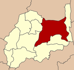 District location in Lopburi Province | |
| Coordinates: 15°12′22″N 101°8′12″E / 15.20611°N 101.13667°ECoordinates: 15°12′22″N 101°8′12″E / 15.20611°N 101.13667°E | |
| Country | Thailand |
| Province | Lopburi |
| Seat | Lam Narai |
| Area | |
| • Total | 1,253.0 km2 (483.8 sq mi) |
| Population (2009) | |
| • Total | 90,224 |
| • Density | 70.7/km2 (183/sq mi) |
| Time zone | UTC+7 (ICT) |
| Postal code | 15130 |
| Geocode | 1604 |
Chai Badan (Thai: ชัยบาดาล, pronounced [t͡ɕʰāj bāː.dāːn]) is a district (amphoe) in the eastern part of Lopburi Province, central Thailand. The local people usually call it Lam Narai, as the district center is in Tambon Lam Narai.
History
Chai Badan was an ancient town in the Pa Sak River valley, controlled from Nakhon Ratchasima. In 1914 it was upgraded to be a district of Phetchabun Province. In 1918 it was moved to be part of Saraburi Province. Finally it became part of Lopburi Province on 1 November 1941.[1]
In 1943 the district office was moved from Chai Badan Sub-district to Bua Chum Sub-district,[2] which was undone one year later.[3] In 1960 it was again moved to Bua Chum.[4] The area around the district office was made the new Sub-district Lam Narai in 1970.[5]
Geography
Neighboring districts are (from the east clockwise) Lam Sonthi, Tha Luang, Phatthana Nikhom, Khok Samrong and Khok Charoen of Lopburi Province, and Si Thep of Phetchabun Province.
The Wang Kan Luang waterfall is the most visited place by Lopburi visitors.
The district is the site of a Royal Thai Air Force gunnery range.[6]
Administration
The district is divided into 17 sub-districts (tambons), which are further subdivided into 136 villages (mubans). Lam Narai has sub-district municipality status (thesaban tambon) and covers part of the tambon Lam Narai and Chai Narai. There are a further 16 tambon administrative organizations (TAO).
| No. | Name | Thai | Villages | Pop.[7] |
|---|---|---|---|---|
| 1. | Lam Narai | ลำนารายณ์ | 12 | 17,488 |
| 2. | Chai Narai | ชัยนารายณ์ | 6 | 6,294 |
| 3. | Sila Thip | ศิลาทิพย์ | 12 | 5,635 |
| 4. | Huai Hin | ห้วยหิน | 8 | 2,741 |
| 5. | Muang Khom | ม่วงค่อม | 11 | 5,650 |
| 6. | Bua Chum | บัวชุม | 9 | 8,071 |
| 7. | Tha Din Dam | ท่าดินดำ | 6 | 4,509 |
| 8. | Makok Wan | มะกอกหวาน | 3 | 1,504 |
| 9. | Sap Takhian | ซับตะเคียน | 6 | 4,896 |
| 10. | Na Som | นาโสม | 6 | 2,655 |
| 11. | Nong Yai To | หนองยายโต๊ะ | 8 | 4,000 |
| 12. | Ko Rang | เกาะรัง | 10 | 6,510 |
| 14. | Tha Manao | ท่ามะนาว | 8 | 3,224 |
| 17. | Nikhom Lam Narai | นิคมลำนารายณ์ | 9 | 4,423 |
| 18. | Chai Badan | ชัยบาดาล | 8 | 6,334 |
| 19. | Ban Mai Samakkhi | บ้านใหม่สามัคคี | 6 | 2,957 |
| 22. | Khao Laem | เขาแหลม | 8 | 3,333 |
The missing numbers belong to tambon which now form Lam Sonthi District
References
- ↑ พระราชบัญญัติเปลี่ยนแปลงเขตจังหวัดลพบุรีและจังหวัดสระบุรี พุทธศักราช ๒๔๘๔ (PDF). Royal Gazette (in Thai). 58 (0 ก): 1379–1381. October 14, 1941.
- ↑ ประกาศกระทรวงมหาดไทย เรื่อง ย้ายที่ว่าการอำเภอชัยบาดาล จังหวัดลพบุรี (PDF). Royal Gazette (in Thai). 60 (56 ง): 3385. 1943-10-19.
- ↑ ประกาศกระทรวงมหาดไทย เรื่อง ย้ายที่ว่าการอำเภอชัยบาดาล จังหวัดลพบุรี (PDF). Royal Gazette (in Thai). 61 (77 ง): 2445–2446. 1944-12-26.
- ↑ ประกาศกระทรวงมหาดไทย เรื่อง ย้ายที่ว่าการอำเภอไชยบาดาลและสถานีตำรวจภูธร (PDF). Royal Gazette (in Thai). 77 (47 ง): 1509. 1960-06-07.
- ↑ ประกาศกระทรวงมหาดไทย เรื่อง ตั้งและเปลี่ยนแปลงเขตตำบลในท้องที่อำเภอชัยบาดาล จังหวัดลพบุรี (PDF). Royal Gazette (in Thai). 87 (85 ง): 2539–2545. 1970-09-08.
- ↑ "Ready for Action". Bangkok Post (Photo caption)
|format=requires|url=(help). 20 December 2017. p. 1. - ↑ "Population statistics 2009". Department of Provincial Administration. Archived from the original on 4 March 2016.
External links
- amphoe.com (Thai)
Lopburi | ||
|---|---|---|
| Main article |  | |
| Capital | ||
| Districts (amphoe) | ||
| Royalty | ||
| Related topics | ||
| Neighboring areas | ||