Sangkhla Buri District
| Sangkhla Buri สังขละบุรี | |
|---|---|
| Amphoe | |
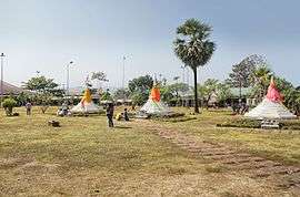 The three pagodas | |
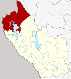 Amphoe location in Kanchanaburi Province | |
| Coordinates: 15°9′20″N 98°27′12″E / 15.15556°N 98.45333°ECoordinates: 15°9′20″N 98°27′12″E / 15.15556°N 98.45333°E | |
| Country | Thailand |
| Province | Kanchanaburi |
| Seat | Nong Lu |
| Area | |
| • Total | 3,349.4 km2 (1,293.2 sq mi) |
| Population (2005) | |
| • Total | 40,162 |
| • Density | 12.0/km2 (31/sq mi) |
| Time zone | UTC+7 (ICT) |
| Postal code | 71240 |
| Geocode | 7108 |

Sangkhla Buri (Thai: สังขละบุรี, pronounced [sǎŋ.kʰlàʔ bū.rīː]) is a district (amphoe) in the Kanchanaburi Province in western Thailand.
Geography
Sangkhla Buri is in the far west of the province, at the boundary to Myanmar. The Three Pagodas Pass is the border crossing station to Myanmar. A large part of the district is covered by the Khao Laem Reservoir, an artificial lake formed by the Vajiralongkorn Dam in the Khwae Noi River.
Neighboring are (from west clockwise) Tanintharyi Division, Mon State and Kayin State of Myanmar, the district Umphang of Tak Province, and Thong Pha Phum of Kanchanaburi.
History
In 1939 the district Wang Ka (วังกะ) was renamed Sangkhla Buri, which was previously the name of the minor district Thong Pha Phum.[1] On May 20, 1941 the district was downgraded to a minor district (King Amphoe) and made a subordinate of Thong Pha Phum district. It then consisted of the four tambon Nong Lu, Prangphle, Laiwo and Lang Phu Sa.[2] It was again upgraded to full district status on 27 July 1965.[3]
Administration
The district is divided into three sub-districts (tambon), which are further subdivided into 20 villages (muban). Wang Ka is a township (thesaban tambon) and covers parts of the tambon Nong Lu. There are a further three tambon administrative organizations (TAO).
| No. | Name | Thai name | Villages | Pop. | |
|---|---|---|---|---|---|
| 1. | Nong Lu | หนองลู | 10 | 30,534 | |
| 2. | Prangphle | ปรังเผล | 4 | 5,191 | |
| 3. | Laiwo | ไล่โว่ | 6 | 4,437 |
Uttamanusorn Bridge
A 2014 Bangkok Post article said that the "Uttamanusorn Bridge, better known as Saphan Mon,...built almost 30 years ago by the people, for the people of Ban Wangka, a Mon village" is the most popular tourist landmark in the district".[4]
References
- ↑ พระราชกฤษฎีกาเปลี่ยนนามอำเภอ กิ่งอำเภอ และตำบลบางแห่ง พุทธศักราช ๒๔๘๒ (PDF). Royal Gazette (in Thai). 56 (0 ก): 354–364. April 17, 1939.
- ↑ ประกาศสำนักนายกรัฐมนตรี เรื่อง ยกฐานะกิ่งอำเภอขึ้นเป็นอำเภอและยุบอำเภอลงเป็นกิ่ง จังหวัดกาญจนบุรี (PDF). Royal Gazette (in Thai). 58 (0 ง): 1238. May 20, 1941.
- ↑ พระราชกฤษฎีกาตั้งอำเภอศรีสวัสดิ์ อำเภอสังขละบุรี อำเภอท่าคันโท อำเภอดอกคำใต้ อำเภอแม่ใจ อำเภอจุน อำเภอขามทะเลสอ อำเภอไพศาลี อำเภอท่าวังผา อำเภอบ้านกรวด อำเภอเด่นชัย อำเภอปทุมรัตน์ อำเภอกะเปอร์ อำเภออากาศอำนวย อำเภอดอนเจดีย์ อำเภอจอมพระ และอำเภอสามโก้ พ.ศ. ๒๕๐๘ (PDF). Royal Gazette (in Thai). 81 (49 ก): 565-. July 27, 1965.
- ↑ Hey governor, mind your own bridge-ness
External links

- amphoe.com
 | ||
| Wikimedia Commons has media related to Sangkhla Buri District. |