Lat Krabang District
| Lat Krabang ลาดกระบัง | |
|---|---|
| Khet | |
 | |
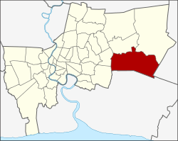 Amphoe location in Bangkok | |
| Coordinates: 13°43′20.34″N 100°45′34.81″E / 13.7223167°N 100.7596694°ECoordinates: 13°43′20.34″N 100°45′34.81″E / 13.7223167°N 100.7596694°E | |
| Country | Thailand |
| Province | Bangkok |
| Seat | Lat Krabang |
| Khwaeng | 6 |
| Area | |
| • Total | 123.859 km2 (47.822 sq mi) |
| Population (2017) | |
| • Total | 173,987[1] |
| • Density | 1,404.71/km2 (3,638.2/sq mi) |
| Time zone | UTC+7 (ICT) |
| Postal code | 10520 |
| Geocode | 1011 |
Lat Krabang (Thai: ลาดกระบัง, pronounced [lâːt krā.bāŋ]) is one of the eastern districts of Bangkok.
Neighboring districts are (from the south clockwise) Bang Bo, Bang Sao Thong and Bang Phli (Samut Prakan Province), Prawet, Saphan Sung, Min Buri and Nong Chok (Bangkok) and Mueang Chachoengsao (Chachoengsao Province).
In October 2005, the plan to create the special administrative area Nakhon Suvarnabhumi around Suvarnabhumi Airport became public. Lat Krabang was among the five districts that were to be included in this new administrative area.
Administration
The district is divided into six sub-districts (khwaeng).
| 1. | Lat Krabang | ลาดกระบัง | |
| 2. | Khlong Song Ton Nun | คลองสองต้นนุ่น | |
| 3. | Khlong Sam Prawet | คลองสามประเวศ | |
| 4. | Lam Pla Thio | ลำปลาทิว | |
| 5. | Thap Yao | ทับยาว | |
| 6. | Khum Thong | ขุมทอง |
Places
- King Mongkut's Institute of Technology Lat Krabang
- Protpittayapayat School
- Lat Krabang Industrial Estate
References
- ↑ "Population and House Report for Year 2017". Department of Provincial Administration, Ministry of Internal Affairs. Retrieved 2018-04-01. (Search page)
External links
.svg.png)
This article is issued from
Wikipedia.
The text is licensed under Creative Commons - Attribution - Sharealike.
Additional terms may apply for the media files.