Bang Phlat District
| Вang Phlat บางพลัด | |
|---|---|
| Khet | |
 | |
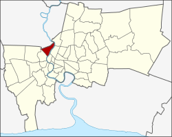 Khet location in Bangkok Province | |
| Coordinates: 13°47′38″N 100°30′18″E / 13.79389°N 100.50500°ECoordinates: 13°47′38″N 100°30′18″E / 13.79389°N 100.50500°E | |
| Country | Thailand |
| Province | Bangkok |
| Seat | Bang Phlat |
| Khwaeng | 4 |
| Khet established | 1987 |
| Area | |
| • Total | 11.360 km2 (4.386 sq mi) |
| Population (2017) | |
| • Total | 92,325[1] |
| • Density | 8,127.20/km2 (21,049.4/sq mi) |
| Time zone | UTC+7 (ICT) |
| Postal code | 10700 |
| Geocode | 1025 |
| Jr. | |
Bang Phlat (Thai: บางพลัด, pronounced [bāːŋ pʰlát]) is one of the 50 districts (khet) of Bangkok, Thailand. Its neighboring districts, clockwise from the north, are Amphoe Bang Kruai, Bang Sue, Dusit, Phra Nakhon, Bangkok Noi, and Taling Chan.
History
Bang Phlat was one of the 25 districts created in 1915, when the inner districts of Bangkok were reorganized.[2] In 1938 the district was abolished and added to Bangkok Noi.[3]
Bang Phlat District was again set up in 1989 by taking four sub-districts from Bangkok Noi.[4] The west side of Borommaratchachonnani Road and Somdet Phra Pin Klao Road were moved back to Bangkok Noi in 1991,[5] creating the new Arun Amarin Sub-district.
Bang Phlat has a number of transliteration spellings that are visible across the district including: Bang Phlat, Bang Phlad, Bang Plat, Bang Plad. It is likely that this spelling will become unified as the new MRT station stop has been titled "Bang Phlat".
The term Bang Phlat meaning "place of lost". Assumed that this district in the past, filled with waterways and overgrown. When people travel from another area, they are often lost. While another description believe that from the Bahasa Malaysia word "palas" which means for Licuala paludosa is a kind of palm tree, that has abounded here in the past.[6][7]
Administration
The district is divided into four sub-districts (khwaeng).
| 1. | Bang Phlat | บางพลัด |
| 2. | Bang O | บางอ้อ |
| 3. | Bang Bamru | บางบำหรุ |
| 4. | Bang Yi Khan | บางยี่ขัน |
Places
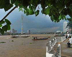
The main road running through Bang Phlat is Charan Sanit Wong, a road that parallels the Chao Phraya to the west from Thon Buri up to the Rama VII bridge.
Bang Phlat has a mixture of light commercial, industrial and residential zones. There are a few medium commercial and residential areas which are growing as the area becomes more prosperous. There are two Express River Boat stations servicing Bang Phlat, Saphan Krung Thon to the south and Saphan Rama 7 to the north.
- Rama VIII Bridge & Rama VIII Park
- Krungthon Bridge
- Wat Kharuehabodi (วัดคฤหบดี)
- Wat Bowon Mongkhon (วัดบวรมงคล)
- Yanhee International Hospital
- Pata Pinklao & Pata Zoo
References
- ↑ "Population and House Report for Year 2017 (see page 2 for data of this district)". Department of Provincial Administration, Ministry of Internal Affairs. Retrieved 2018-04-01. (Search page)
- ↑ ประกาศ ยกเลิกอำเภอชั้นใน ๗ อำเภอ และตั้งอำเภอชั้นในขึ้นใหม่ ๒๕ อำเภอ (PDF). Royal Gazette (in Thai). 32 (0 ก): 335–348. 1915-10-31.
- ↑ ประกาศสำนักนายกรัฐมนตรี เรื่อง ยุบรวมอำเภอ และยุบอำเภอลงเป็นกิ่งอำเภอ (PDF). Royal Gazette (in Thai). 55 (0 ง): 1840. 1938-08-29.
- ↑ ประกาศกระทรวงมหาดไทย เรื่อง เปลี่ยนแปลงพื้นที่เขตบางกอกน้อย และตั้งเขตบางพลัด (PDF). Royal Gazette (in Thai). 106 (208 ง ฉบับพิเศษ): 10. 1989-11-24.
- ↑ ประกาศกระทรวงมหาดไทย เรื่อง เปลี่ยนแปลงพื้นที่เขตบางกอกน้อยและเขตบางพลัด กรุงเทพมหานคร (PDF). Royal Gazette (in Thai). 108 (202 ก): 1095–1098. 1991-11-21.
- ↑ ""บางพลัด" ไม่น้อยหน้า จัดเต็ม วาเลนไทน์มอบ "ผ้ายันต์ วิน วิน เจ้าคุณธงชัย" เสริมมงคลชีวิตคู่". Matichon (in Thai). 2017-02-14.
- ↑ ป.ศรีนาค (2017-01-28). "ชื่อมลายูในกรุงเทพฯ". ศิลปวัฒนธรรม (in Thai).
External links
- bangpladliving.com website offering google map with local information in English
- BMA website with the tourist landmarks of Bang Phlat
- Bang Phlat district office (Thai only)
.svg.png)