Phra Nakhon Si Ayutthaya (city)
| Phra Nakhon Si Ayutthaya พระนครศรีอยุธยา | ||
|---|---|---|
| City Municipality | ||
|
City of Phra Nakhon Si Ayutthaya เทศบาลนครพระนครศรีอยุธยา | ||
 | ||
| ||
 Phra Nakhon Si Ayutthaya Location in Thailand | ||
| Coordinates: 14°20′52″N 100°33′38″E / 14.34778°N 100.56056°ECoordinates: 14°20′52″N 100°33′38″E / 14.34778°N 100.56056°E | ||
| Country | Thailand | |
| Province | Ayutthaya | |
| District | Phra Nakhon Si Ayutthaya | |
| Named for | Ayodhya, Uttar Pradesh, India | |
| Government | ||
| • Type | City Municipality | |
| • Mayor | Somsong Sappakosonlakul | |
| Area | ||
| • Total | 14.84 km2 (5.73 sq mi) | |
| Population (2014) | ||
| • Total | 52,952 | |
| • Density | 3,600/km2 (9,200/sq mi) | |
| Registered residents only | ||
| Time zone | UTC+7 (ICT) | |
| Postcode | 13xxx | |
| Area code | (+66) 35 | |
| Website | ayutthayacity.go.th/ | |
Phra Nakhon Si Ayutthaya (Thai: พระนครศรีอยุธยา, pronounced [pʰráʔ ná(ʔ).kʰɔ̄ːn sǐː ʔā.jút.tʰā.jāː]; also spelled "Ayudhya"), or locally and simply Ayutthaya, is the former capital of Phra Nakhon Si Ayutthaya province in Thailand. Located in the valley of the Chao Phraya River.
Etymology
Ayutthaya is named after the city of Ayodhya in India, the birthplace of Rama in the Ramayana (Thai, Ramakien); phra (from Khmer: ព្រះ Preah) is a Thai royal and noble title; nakhon designates an important or capital city (from Sanskrit: Nagar); the Thai honorific sri or si is from the Indian term of veneration Sri.
History
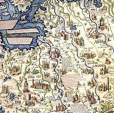
Ayutthaya was founded in 1351[a] by King U Thong, who went there to escape a smallpox outbreak in Lop Buri and proclaimed it the capital of his kingdom, often referred to as the Ayutthaya kingdom or Siam. Ayutthaya became the second Siamese capital after Sukhothai.[2] It is estimated that Ayutthaya by the year 1600 had a population of about 300,000, with the population perhaps reaching 1,000,000 around 1700, making it one of the world's largest cities at that time,[3] when it was sometimes known as the "Venice of the East".[4][5]
In 1767, the city was destroyed by the Burmese army, resulting in the collapse of the kingdom. The ruins of the old city are preserved in the Ayutthaya historical park,[6] which is recognised internationally as a UNESCO World Heritage Site. The ruins, characterised by the prang (reliquary towers) and gigantic monasteries, give an idea of the city's past splendour.[7] Modern Ayutthaya was refounded a few kilometres to the east.
Geography
The city is about 40 miles (64 km) north of Bangkok.[8]
Climate
Ayutthaya, located in the central plains, is affected by three seasons:
- Hot Season: March – May
- Rainy season: June – October
- Cool season: November - February
| Climate data for Ayutthaya | |||||||||||||
|---|---|---|---|---|---|---|---|---|---|---|---|---|---|
| Month | Jan | Feb | Mar | Apr | May | Jun | Jul | Aug | Sep | Oct | Nov | Dec | Year |
| Average high °C (°F) | 31.0 (87.8) |
33.3 (91.9) |
35.4 (95.7) |
35.9 (96.6) |
34.3 (93.7) |
32.6 (90.7) |
32.0 (89.6) |
31.4 (88.5) |
31.3 (88.3) |
31.3 (88.3) |
30.7 (87.3) |
30.0 (86) |
32.4 (90.3) |
| Average low °C (°F) | 17.0 (62.6) |
19.4 (66.9) |
22.3 (72.1) |
24.3 (75.7) |
24.5 (76.1) |
24.3 (75.7) |
24.0 (75.2) |
23.8 (74.8) |
23.5 (74.3) |
22.5 (72.5) |
20.0 (68) |
17.4 (63.3) |
21.9 (71.4) |
| Average rainfall mm (inches) | 2.4 (0.094) |
18.8 (0.74) |
43.5 (1.713) |
67.9 (2.673) |
208.0 (8.189) |
223.0 (8.78) |
180.8 (7.118) |
260.0 (10.236) |
213.9 (8.421) |
167.6 (6.598) |
37.1 (1.461) |
0.8 (0.031) |
1,423.8 (56.054) |
| Average rainy days | 0 | 1 | 4 | 6 | 15 | 16 | 17 | 19 | 17 | 12 | 3 | 1 | 111 |
| Source: Thai Meteorological Department[9] | |||||||||||||
Ayutthaya City Sites
Notable cultural sites
| Name | Picture | Built | Sponsor(s) | Notes |
|---|---|---|---|---|
| Wat Chai Watthanaram | 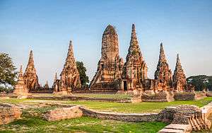 |
1630 | King Prasat Thong | One of the most famous temples in Ayutthaya |
| Wat Mahathat |  |
1374 | King Borommaracha I | |
| Wat Phanan Choeng | .jpg) |
1324 | ||
| Wat Phra Si Sanphet | 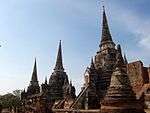 |
1350 | King Ramathibodi I | |
| Wat Ratchaburana | .jpg) |
1424 | King Borommarachathirat II | |
| Wat Lokaya Sutharam |  |
1452 | King Intharacha | |
| Wat Phra Ram | 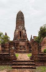 |
1369 | King Ramesuan | |
| Wat Phutthaisawan | 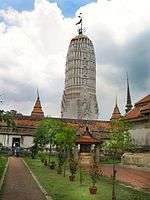 |
Before Ayutthaya was founded. | King Ramathibodi I | |
| Wat Thammikarat | 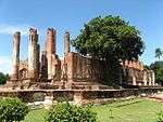 |
Before Ayutthaya was founded. | King of Lavo | |
Museums
- Ayutthaya Historical Study Centre
- Chao Sam Phraya National Museum: The museum was specially display the objects excavated at Wat Racha Burana and Wat Maha That.
Other tourism sites
- Wang Luang
- Wat Na Phra Men
- Wat Suwan Dararam
- Wihan Phra Mongkhon Bophit
- St. Joseph's Church
- Baan Hollanda
The city is located at the junction of the Chao Phraya, Lopburi and Pa Sak rivers, and on the main north-south railway linking Chiang Mai to Bangkok. The old city is on an island formed by a bend of the Chao Phraya on the west and south sides, the Pa Sak on the east side and the Klong Muang canal on the northern side.
The approximate centre of the old city is 14°20′N 100°34′E / 14.333°N 100.567°E.
Transport
Ayutthaya is accessible by air and rail.
Air
The closest airport is Bangkok’s Don Mueang International Airport, a hub for regional budget carriers. An elevated walkway connects Terminal 1 to the Don Muang Train Station, where can catch one of the Ayutthaya-bound trains that regularly roll through.[10]
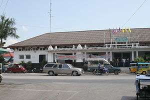
Rail
Trains to Ayutthaya leave Bangkok's Hua Lamphong Station approximately every hour between 04:20 am. and 10:00 pm. The 3rd class fare is 15 bahts for the 1.5 hour trip. Train schedules are available from the information booth at Hua Lamphong Station, Bangkok.[11]
In fiction
- A Thailand-themed town named "Ayothaya" appears in the PC MMORPG Ragnarok Online.
- Ayutthaya is a stage in Soul Calibur II.
- The temples in Wat Phra Si Sanphet and Wat Ratchaburana from Ayutthaya appear in Kickboxer (as "Stone City"), Mortal Kombat, Mortal Kombat Annihilation, and throughout Mortal Kombat Conquest.[12]
- The lying Buddha statue from the Ayutthaya ruins appears in Sagat's stage in most of the Street Fighter games.[13]
- It was featured in the 2005 movie "The King Maker".
- The 1630 destruction of the Japanese quarter of Ayutthaya at the orders of Prasat Thong and its consequences is central to one of the stories in the 1632 series anthology Ring of Fire III, "All God's Children in the Burning East" by Garrett W. Vance.
- In the 2010 Nintendo DS game Golden Sun: Dark Dawn, the main characters visit the city of 'Ayuthay', which draws heavily on Thai culture and architecture.
- A Thailand-themed map named "Ayutthaya" appears in the game Overwatch (video game).
Gallery
 Wat Phra Si Sanphet
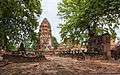 Mahathat, Ayutthaya historical park
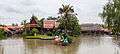 Floating market of Ayutthaya
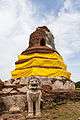 Thammikarat temple
Notes
a The city was founded on Friday, the 6th day of the waxing moon of the 5th month, 1893 Buddhist Era, corresponding to Friday, 4 March 1351 Common Era, according to the calculation of the Fine Arts Department of Thailand.[14]
References
- ↑ http://www.nationmultimedia.com/2006/09/06/headlines/headlines_30012911.php
- ↑ "Historic City of Ayutthaya - UNESCO World Heritage Centre". UNESCO World Heritage Centre. Retrieved 24 August 2012.
- ↑ George Modelski, World Cities: –3000 to 2000, Washington DC: FAROS 2000, 2003. ISBN 978-0-9676230-1-6. See also Evolutionary World Politics Homepage.
- ↑ "Ayutthaya, Thailand's historic city". The Times Of India. 2008-07-31.
- ↑ Derick Garnier (2004). Ayutthaya: Venice of the East. River books. ISBN 974-8225-60-7.
- ↑ "Ayutthaya Historical Park". Asia's World Publishing Limited. Retrieved 2011-09-22.
- ↑ "Historic City of Ayutthaya". UNESCO. Retrieved 2011-09-22.
- ↑ Bellamy, Patrick. "The Hunt." Hambali: Mastermind of Terror. Crime Library. Retrieved on March 17, 2014.
- ↑ "30 year Average (1961-1990) - AYUTTHAYA". Thai Meteorological Department. Retrieved 2011-11-12.
- ↑ https://www.travelfish.org/transport/thailand/bangkok_and_surrounds/ayutthaya/ayutthaya/all
- ↑ http://www.ayutthaya-history.com/Temples_Ruins_Introduction.html
- ↑ Mortal Kombat (Laser disc) Audio Commentary, UPC: 014381302165.
- ↑ "The Buddha Statue". Fightingstreet.com. Retrieved 2011-12-18.
- ↑ Rotchanaratha, Wina, ed. (1999). Prachum Phongsawadan Chabap Kanchanaphisek Lem Nueng ประชุมพงศาวดาร ฉบับกาญจนาภิเษก เล่ม ๑ [Golden Jubilee Collection of Historical Archives, Volume 1] (in Thai). Bangkok: Fine Arts Department of Thailand. p. 211. ISBN 9744192151.
Further reading
- Stefan Halikowski Smith, Creolization and Diaspora in the Portuguese Indies: The Social World of Ayutthaya, 1640-1720 (Leiden, Brill, 2011) (European Expansion and Indigenous Response, 8).
External links
| Wikimedia Commons has media related to Ayutthaya (city). |
| Wikisource has the text of the 1911 Encyclopædia Britannica article Ayuthia. |
- http://www.ayutthaya.go.th/eng_travel.htm Website of municipality

| Authority control |
|---|