Astore District
| Astore District ضلع استور | |
|---|---|
| District | |
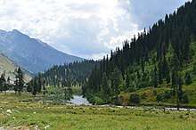
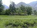
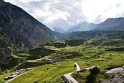 The Rama Valley near Astore | |
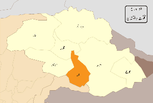 map of Gilgit-Baltistan (in yellow) whereas Astore district location is orange colored . | |
| Country | Pakistan |
| Region | Gilgit-Baltistan |
| Area | |
| • Total | 5,092 km2 (1,966 sq mi) |
| Population (1998) | |
| • Total | 71,666 |
| Time zone | UTC+5 (PST) |
| Number of Tehsils | 2 |
Astore (Urdu: ضلع استور) is one of the ten districts of Gilgit-Baltistan, Pakistan. The district contains the Astore Valley (with the town of Astore) and is bounded to the west by Diamer District (from which it was separated in 2004), to the north by Gilgit District, to the east by Skardu District and to the south by Khyber-Pakhtunkhwa and Neelum District of Azad Kashmir. According to the 1998 census of Pakistan the population was 71,666.
The valley
The Astore valley has an area of 5,092 km² and an altitude of 2600m.
Accessibility
Astore is connected to Gilgit which is well connected by air with Islamabad(weather dependent) and by road with Islamabad/Rawalpindi, Skardu and Chitral. You can take a flight to Gilgit from the capital of the country and drive to Astore from Gilgit on metalled road.
It connects its extremist with the Indian held Kashmir, Northwest connects with Pakistan held Kashmir, in the East it connects with the Skardu, in the West it connects to outskirts of Chilas. there are two ways to access to Astor, first is via Deawsi 95 km from Skardu city, but it is can not be use from November to June due to heavy snowfall and second way, for all seasons, is via Joglot 135 km from Gilgit city.
History
According to the Imperial Gazetteer of India, around 1600:
| “ | Ghāzī Mukhpun, a Persian adventurer, is said to have married a princess of the Skārdu reigning family. The four sons born of this union became Rās of Skārdu, Astor, Rondu, and Kharmang respectively, and from them are descended the families of the present chiefs of those places. Afzal, Guada, Chilma respectively was sons of Astor. They lived in Juttay, Ganda gam (Arzal abad), Gudai (Guada abad), Chilm (Chilma abad) respectively. The independence of Astor ceased at the Dogra conquest.[1] | ” |
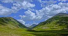
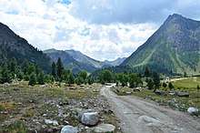
 astore green mountains
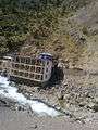 astore
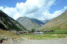
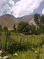 bullan astore
Climate
Astore valley has a moderate climate during summer. In winter it can snow up to 6 inches (15 cm) in the main valleys and up to 2–3 feet (60–90 cm) in the mountains. In Mirmalik valley it snows up to 6 feet (1.8 m) in February.
Languages
The main language spoken in the valley is Shina. Urdu, which is the National language of Pakistan, is the second most frequently spoken language.There are different dialect of Shina spoken in the region. Since Astore has a history of modest tourist traffic in the summer months, local guides and police in Tarashing or Astore may speak some English.
Education
According to the Alif Ailaan Pakistan District Education Rankings 2015, Astore is ranked 32 out of 148 districts in terms of education. For facilities and infrastructure, the district is ranked 114 out of 148 and the first lady Governor of Pakistan (Gilgit-Baltistan) Dr. Shama Khalid belong to Astore District.
Villages
- Astore is the common name
- Bunji starting point of Astore,
- Eidgah Centre of Astore, major Govt offices and hotels are here,
- Finah is consisted of 8 small villages, Central Finah, Goramain, Eldar, Hernall, Danal(Ali Abad),
Maja Fuchung, Fuchung(Abbas Twon) Gorchi Fuchung. 2 lakes "Nelo Ser, Bodu ser, are situated here. Population 30% of whole Population of Astore, Educational proportion is high other than villages. mostly Peoples are depending on Govt Employees.
- Louse
Center louse bala .comprises 11 small villages ""Louse Bala, louse pain, hafiz abad, louse dash, torpie, upper lazanga(have two lakes nelo ser and bodu ser), lower lazanga, pophfl, shogart, hopek, dacha,"" Beautiful parishing area and Allah Wala lake situated here
- Choungrah Rama lake situated here.
- Gorikot
- Nowgam
- Chorit
- Bubind
- Tarzay
- Tarashing
- Rupal
- Dashkin
- Douan
- Khuma
- Parishing consisting Theeg bala, theeg paine, Gutamsar, very Beautiful area.
- Khangrool
- Ramkha
- Chougam
- Nasir Abad
- Mushkay
- Rattu
- Chhaine
- Faqir Coat
- Dirlay
- Shekong
- Shankar garh
- Sakamal
- Sakamal
- Chichidi
- Pakora
- Kushinat
- Gudai
- Yagum
- kharbai
- Chilim Dewsai National Park situated here
Transport
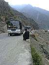
There were some negative perceptions in past due to rough mode of transport but nowadays there are paved roads connecting Gilgit and Islamabad through the Karakorum Highway. Landslides and rockfall may be an issue in some areas of the Indus Valley. There is a permanent road through Gilgit as well as seasonal road access via Deosai Plateau to Skardu. Here you can obtain all types of vehicles (Jeeps, taxis, wagons, SUVs) and hire jeeps and SUVs at affordable prices. The most used vehicles are Jeeps and SUVs with a local preference for Pajeros and Landcruisers.
Places of interest
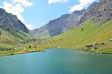
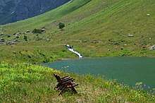
Astore lies about the massive base of Nanga Parbat, the 9th highest peak in the world. To the south of the Nanga Parbat massif lies Rama Valley, which is home to Rama Lake, with basic facilities for visitors. It has a hotel called the PTDC, constructed by the government of Pakistan. Astore valley is a unique area for tourists to visit, surrounded by the high peaks of the far western Himalaya. Nearby the two river junction the village Louse, popular for apples, apricot, cherry and other fruits especially the wild almond oil. Louse a small village with literacy rate of about 95%, the only biggest power house for electricity supply up to 1000 kW to whole district approx since 1987, nearby Louse a peaks include Nanga Parbat, Shaigiri, Rupal Peak, Chongra Peak and Laila Peak (Rupal Valley). Astore Valley ascends from the Indus River Valley near Jaglot, Pakistan..
Deosai plains are the highest plateau in himalayas and are most picturesque with a bowl shaped lake, wild flowers, and a habitat of brown bear.The easiest route from Astore is via, Gorikot, (tarzay sultan abad) Gudai, Chilum and then a track leads to this area with little steep hike. It has been declared a Natural park, a special status to preserve its flora and fauna.
Rupal Valley is one of the prominent tourism spots of Astore Valley. it lies in the east of Nanga Parbat, the killer mountain (8126m). Moreover, a huge amount of water from Nanga Parbat Glacier, named Rupal River passes through Tarishing and meet with Nala Rattu at Rehmanpur. Then it flows towards east and meet with Nala Gudai at the starting point of Gorikot and become a major river of Astore Valley. This river falls in Indus River at Bunji, one of Astore Valley's village.
References
- ↑ Gilgit - Imperial Gazetteer of India, v. 12, p. 239 According to the Imperial Gazetteer, which was compiled in the first decade of the twentieth century, the marriage took place over three hundred years ago
- ↑ "Individual district profile link, 2015". Alif Ailaan. Retrieved 2015-05-07.
| Passes | 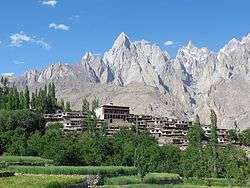 | |
|---|---|---|
| Valleys | ||
| Cities and towns | ||
| Rivers, glaciers and lakes | ||
| Architecture | ||
| See also | ||
Coordinates: 35°2′20.3″N 75°6′36.91″E / 35.038972°N 75.1102528°E
www.marifatwelfare.org Facebook: marifat.welafre.organization.astore.pakistan