Governors Island
|
Governors Island | |
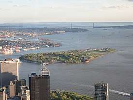 Governors Island viewed from One World Observatory | |
   | |
| Location | New York City, New York, U.S. |
|---|---|
| Coordinates | 40°41′29″N 74°0′58″W / 40.69139°N 74.01611°WCoordinates: 40°41′29″N 74°0′58″W / 40.69139°N 74.01611°W |
| Area | 172 acres (70 ha) |
| Architectural style | Colonial Revival, Greek Revival |
| Visitation | 443,000 (2010) |
| NRHP reference # | 85002435 |
| Significant dates | |
| Added to NRHP | February 4, 1985[1] |
| Designated NHL | February 4, 1985[2] |
| Designated NMON | January 19, 2001 |
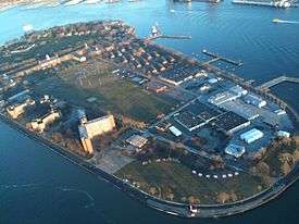
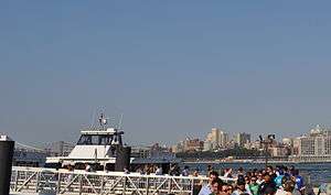
Governors Island is a 172-acre (70 ha) island in New York Harbor, approximately 800 yards (732 m) from the southern tip of Manhattan Island and separated from Brooklyn by Buttermilk Channel, approximately 400 yards (366 m). It is part of the borough of Manhattan in New York City. The National Park Service administers a small portion of the north of the island as the Governors Island National Monument, while the Trust for Governors Island operates the remaining 150 acres, including 52 historic buildings. Today, Governors Island is a popular seasonal destination open to the public between May and September with a 43-acre public park completed between 2012 and 2016, free arts and cultural events, and recreational activities. The island is accessed by ferries from Brooklyn and Manhattan.
The Lenape of the Manhattan region referred to the island as Paggank ("nut island"), likely after the island's plentiful hickory, oak, and chestnut trees;[3] the Dutch explorer Adriaen Block called it Noten Eylant, a translation, and this was borrowed into English as Nutten Island. The island's current name, made official in 1784, stems from the British colonial era, when the colonial assembly reserved the island for the exclusive use of New York's royal governors.
In 1776, during the American Revolutionary War (1775–1783), Continental Army troops raised defensive works on the island, which they used to fire upon British ships before they were taken. From 1783 to 1966, the island was a United States Army post, and later from 1966 to 1996, the island served as a major United States Coast Guard installation. About 103 acres (42 ha) of fill was added to the island by 1912, making the island a 172-acre (70 ha) island.[4]
History
.jpg)
Colonial period
In 1524, Giovanni da Verrazzano saw the then called Paggank island, becoming the first European in record to do so. (Island of Nuts;[3] described above) by the Native Americans.[5]
In May 1624, Noten Eylandt ("Island of Nuts"; officially renamed Governors Island in 1784) was the landing place of the first settlers in New Netherland. They had arrived from the Dutch Republic with the ship New Netherland under the command of Cornelius Jacobsen May, who disembarked on the island with thirty families in order to take possession of the New Netherland territory.[6] As such, the New York State Senate and Assembly recognize Governors Island as the birthplace of the state of New York, and also certify the island as the place on which the planting of the "legal-political guaranty of tolerance onto the North American continent" took place.[7]
In 1633, the fifth director of New Netherland, Wouter van Twiller, arrived with a 104-man regiment on Governors Island—its first use as a military base. Later he operated a farm on the island. He secured his farm by drawing up a deed on June 16, 1637, which was signed by two Lenape, Cacapeteyno and Pewihas, on behalf of their community at Keshaechquereren, situated in what today is New Jersey.
New Netherland was conditionally ceded to the English in 1664, and the English renamed the settlement New York in June 1665.[8] By 1674, the British had total control of the island.[9]
American Revolution
After the beginning of the American Revolutionary War, in one night, April 9, 1776, Continental Army General Israel Putnam fortified the island with earthworks and 40 cannons in anticipation of the return of the British Army and navy who had quit New York City the year before. The harbor defenses on the island continued to be improved over the summer, and on July 12, 1776, engaged HMS Phoenix and HMS Rose as they made a run up the Hudson River to the Tappan Zee. The colonists' cannon inflicted enough damage to make the British commanders cautious of entering the East River, which later contributed to the success of General George Washington's retreat across it from Brooklyn into Manhattan after the Battle of Long Island (also known as the Battle of Brooklyn), the British Army effort to take Brooklyn Heights overlooking Manhattan and the largest battle of the entire war.[9]
The Continental Army forces collapsed after being flanked and eventually withdrew from Brooklyn and from Governors Island as well, and the British occupied it in late August. From September 2 to 14, the new British garrison would engage volleys with Washington's guns on the battery in front of Fort George in Manhattan.[10] The fort, along with the rest of New York City, was held by the British for the rest of the war until Evacuation Day at the end of the war in 1783.
Late 18th through 19th centuries
At the end of the Revolution, the island, as a former holding of the Crown, came into ownership by the state of New York and saw no military usage. Prompted by the unsettled international situation between the warring powers of France and Great Britain and the need for more substantial harbor fortifications, the Revolutionary War-era earthworks were rehabilitated into harbor defenses by the city and state of New York.
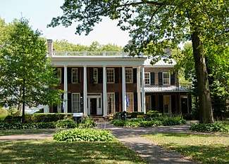
Noten (in pidgin language, "Nutten") Island was renamed Governors Island in 1784 as the island, in earlier times, had been reserved by the British colonial assembly for the exclusive use of New York's royal governors. The Governor's House (perhaps ca 1703, with additions) survives as the oldest structure on the island.[11]
By the late 1790s, the Quasi-War with France prompted a national program of harbor fortifications and the state of New York began improvements as a credit for its Revolutionary War debt. In February 1800, the island was conveyed to the federal government, which undertook the reconstruction of Fort Jay and new construction of two waterfront batteries, Castle Williams and South or Half Moon Battery.[9]
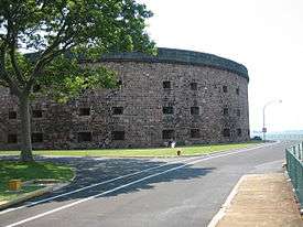
Two forts were built. The first, Fort Jay, was built in 1794 by the state of New York on the site of the earlier Revolutionary War earthworks, and was originally a square four-bastioned fort of earthworks and timber. A sandstone and brick gate house topped with a sculpture of an eagle dates to that time and is the oldest structure on the island. From 1806 to 1809, Fort Jay, then renamed Fort Columbus was reconstructed in more substantial brick and granite with the addition of a ravelin on its north face, giving the fort its current five-point-star appearance, to better protect the fort from a Manhattan-based attack and to more directly place cannon fire on to the East and Hudson Rivers.[9] The second major fortification, Castle Williams, was based on a design by Colonel Jonathan Williams; construction started in 1807 and substantially completed in November 1811. Located on a rocky shoal extending from the northwest corner of the island, it was inspired by then-modern French thinking on fortifications, but a pioneering design for American fortification. It was a designed as a circular structure that could project a 320 degree arc of cannon fire from three levels of casemates (bomb-proof rooms holding two cannons each) and roof, holding 103 cannon gun emplacements.[9]
Fort Jay and Castle Williams are considered among the best remaining examples of First System (Fort Jay) and Second System (Castle Williams) American coastal fortification. They proved useful soon after completion, as they were used to defend the city in the War of 1812.[9] However, within two decades, their defenses were antiquated and the forts' usages needed to be downsized. Therefore, part of Governors Island was repurposed for civilian use. However, the Army still retained military operations, with an "administrative and training center" on the island and a muster station throughout the Mexican–American War and American Civil War; in addition, there was an arsenal and Army-operated music school located on the island.[9]
During the American Civil War, Castle Williams held Confederate prisoners of war and Fort Jay held captured Confederate officers. After the war, Castle Williams was used as a military stockade and became the east coast counterpart to military prisons at Fort Leavenworth, Kansas, and Alcatraz Island, California.[9] In 1878, the military installation on the island, then known collectively as Fort Columbus, became a major Army administrative center. Army officers' families started to move in, and resources, such as a movie theater, a YMCA, an "officer's club," a public school, and three chapels, were built.[9] In 1885, the first incinerator in the U.S. was built on Governors Island.[12]
20th century
Using material excavated from the first New York City subway line (the IRT Lexington Avenue Line under Lexington Avenue), the Army Corps of Engineers supervised the deposit of 4,787,000 cubic yards (3,660,000 m3) of fill on the south side of Governors Island, adding 103 acres (42 ha) of flat, treeless land by 1912 and bringing the total acreage of the island to 172.[4]
By 1912, the island's administrative leaders included General Tasker H. Bliss, who would become Army Chief of Staff in 1917.[13] In 1939, the island became the headquarters of the U.S. First Army.[9] Throughout this period, the army culture on the island grew.[9]
The Brooklyn–Battery Tunnel passes underwater and off-shore of the island's northeast corner, its location marked by a ventilation building connected to the island by a causeway. At one point prior to World War II, Robert Moses proposed a bridge across the harbor, with a base located on Governors Island. The intervention of the War Department quashed the plan, calling it a possible navigational threat to the Brooklyn Navy Yard.
On June 19, 1937, the island celebrated its third century after purchase. Military groups in their local uniforms participated in a review on the north parade ground, the glacis of Fort Jay, including the Old Guard State Fencibles.[14]
Prior to the construction of Floyd Bennett Field in Brooklyn, the island was considered as a site for a municipal airport, and it held a small grass strip, the Governors Island Army Airfield, from the 1950s until the 1960s.[15]
After a yearlong study of by the Department of Defense to cut costs and reduce the number of military installations, the Army announced in November 1964 that Fort Jay and Brooklyn Navy Yard were to be closed by 1966.[9]
Coast Guard era
When the Army left Governors Island in 1966, the installation became a United States Coast Guard base.[9] The Coast Guard saw the island as an opportunity to consolidate and provide more facilities for its schools, and as a base for its regional and Atlantic Ocean operations. This was the Coast Guard's largest installation, and for them as the Army, served both as a self-contained residential community, with an on-island population of approximately 3,500, and as a base of operations for the Atlantic Area Command, its regional Third District command, Maintenance and Logistics Command, various schools which were relocated from Coast Guard Station New London in New London, Connecticut, and the local office of the Captain of the Port of New York.
It was also homeport for several U.S. Coast Guard cutters including USCGC Dallas (WHEC-716), USCGC Gallatin (WHEC-721), USCGC Morgenthau (WHEC-722), USCGC Tamaroa (WMEC-166) and USCGC Sorrel (WLB-296).
In the thirty years of occupation on the island, the Coast Guard began a long, slow process of upgrading facilities and infrastructure that had been little improved upon since the 1930s. This effort also prompted a recognition of the island's military heritage by having 92 acres (370,000 m2) recognized as a National Historic Landmark on February 4, 1985, recognizing its wide range and representation of Army fortification, administrative and residential architecture dating from the early days of the nation.[2][16][17]
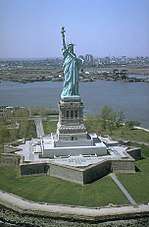
During this time, Governors Island has served as the backdrop for a number of historic events. In 1986, the island was the setting for the relighting of the newly refurbished Statue of Liberty by President Ronald Reagan. On December 8, 1988, along with Vice President and President elect George Bush, President Ronald Reagan held his final meeting as president with Soviet leader Mikhail Gorbachev in the Commanding Officer's quarters. In July 1993, the United Nations sponsored talks at the South Battery Officer's Club to help restore democratic rule in Haiti resulting in the Governors Island Accord, signed between Haitian political leaders.[18]
Like the Army 30 years before, the U.S. Department of Transportation, then parent of the Coast Guard, was compelled to cut costs as other federal agencies in the early 1990s. Because of its high operating costs and remote location from most of its activity in Gulf of Mexico and the Caribbean, the Governors Island base was identified for closure in 1995. The closure was an agency initiative and not part of the Base Realignment and Closure Commission (BRAC) process that impacted numerous Department of Defense installations at that time.
By September 1996, the Coast Guard had relocated all functions and residential personnel to offices and bases in Rhode Island and Virginia. The Coast Guard left a caretaker detachment to maintain the island along with the General Services Administration (GSA) while its future was determined. With the departure of the Coast Guard, almost two centuries of the island's use as a federal military reservation concluded. The disposal of the island as excess federal property was outlined in the Budget Reduction Act of 1996. The legislation set a deadline and directed that the island be sold at a fair market value by GSA by 2002, but gave the city and state of New York a right of first refusal, a provision that was inserted into the legislation by New York senator Daniel Patrick Moynihan who envisioned the island with great potential as a public and civic resource.
Redevelopment and future uses
Early proposals
With the announcement of the Coast Guard base closure and departure, city and state officials along with private developers and civic planners began to offer opinions and ideas on the island's future that included housing, parks, education and private development.
In 1996, Van Alen Institute hosted an ideas competition called "Public Property" which asked designers "to consider the urban potential of Governors Island in terms of spatial adjacencies and experiential overlaps between a range of actions, actors, events, and ecologies... to acknowledge the physical reality of cities and their historic programmatic complexity as fundamental to the survival of a vital public realm." The competition was open to anyone who registered. More than 200 entries from students, faculty, and landscape architects in 14 different countries were received. The jury members included: Andrea Kahn, Christine Boyer, Miriam Gusevich, Judith Henitz, Carlos Jimenez, and Enric Miralles.
A proposal to adaptively reuse Castle Williams for a New Globe Theater was designed by architect Norman Foster.[19] The non-profit organization worked in partnership with Shakespeare's Globe Theater in London to develop a proposal and seek backing for a cultural center and performance space in the Castle. With the completion of a National Park Service general management plan for Castle Williams and Fort Jay in 2009, it was determined that the proposed use of the Castle for the theater was not congruous with its historical significance.
In a last-minute act while in office, President Bill Clinton designated 22 acres of the island, including the two great forts, as Governors Island National Monument on January 19, 2001. In the next year on April 1, 2002, President George W. Bush, Governor Pataki, and Mayor Michael Bloomberg announced that the federal government would sell Governors Island to the people of New York for a nominal cost, and that the island would be used for public benefit. At the time of the transfer, deed restrictions were created that prohibit permanent housing and casinos on the island. On January 31, 2003, 150 acres of Governors Island were transferred to the people of New York, to be administered by a joint city-state agency, the Governors Island Preservation and Education Corporation (GIPEC). The remaining 22 acres was legally reaffirmed by presidential proclamation on February 7, 2003, as the Governors Island National Monument, to be administered by the National Park Service.
On January 19, 2001, Fort Jay and Castle Williams, two of the island's three historical fortifications, were proclaimed a National Monument. On January 31, 2003, 150 acres (61 ha) of the island was transferred to the State and City of New York for $1. The remainder, a 22 acres (9 ha) portion, was transferred to the United States Department of the Interior as the Governors Island National Monument, administered by the National Park Service. The 150-acre portion of the island not included in the National Monument is administered by The Trust for Governors Island, an entity of the City of New York and the successor of the joint city/state established redevelopment entity, the Governors Island Preservation and Education Corporation. The transfer included deed restrictions which prohibit permanent housing or casinos on the island.
On February 15, 2006, Governor George Pataki and Mayor Michael Bloomberg called for "visionary ideas to redevelop and preserve Governors Island"[20] to be submitted to Governors Island Preservation and Education Corporation (GIPEC). The announcement said proposals should "enhance New York's place as a center of culture, business, education and innovation," include public parkland, contribute to the harbor's vitality and stress "environmentally sustainable development." Deputy Mayor Dan Doctoroff said whatever group or entity is selected to develop the island would assume the $12 million annual maintenance costs that are now split between the city and state. In early 2007, GIPEC paused in the search for developers, focusing on the development of a major park on the island as called for in the deed that conveyed the island from the federal government to the city and state of New York.
Early redevelopment efforts and construction
In 2007, the Governors Island Preservation and Education Corporation announced five finalist design teams that were chosen to submit their ideas for the future park and Great Promenade;[21][22] the GIPEC had awarded leases to its first two tenants a year before.[22] The corporation appointed West 8, Diller Scofidio + Renfro, Rogers Marvel Architects, Quennell Rothschild & Partners, and SMWM to design a development plan for Governors Island.[23][24] The plan included 87 acres (35 ha) of open space on the island, as well as provided for the restoration of the historic district and a new park on the southern half of the island.[21] Each firm was asked their visions for the new park. Dutch landscape architecture firm West 8's proposal featured dramatic topography "in concert with winding pathways and trees to create 'conceal and reveal' vistas, choreographing the park experience."[25] The firm also proposed free bicycle rentals around the island;[21][23][26] and, since the island is windy, designed their proposed topography to provide moments of shelter.[23] With transportation to and from the island, one idea considered was an aerial gondola system designed by Santiago Calatrava.[23][27]
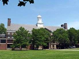
There are very few tenants on the island. Fewer than 1,000 workers, artists, and students work or live on the island.[28] However, in 2009, a 3-acre (12,000 m2) commercial organic farm, operated by the non-profit organization, Added Value, was launched.[29] In 2010, the Urban Assembly New York Harbor School, a small public high school in Bushwick, Brooklyn, was relocated to the Island, remodeling the former Coast Guard clinic in Building 555. Also that year, artist studios run by the Lower Manhattan Cultural Council and housed in a portion of Building 110 opened, and New York University announced an expansion plan that included a campus on the Island, "complete with dorms and faculty housing."[30]
In April 2010, the city entered an agreement to take full control of the island's development from the state of New York through a newly established Trust for Governors Island, and unveiled a new master development plan. Under the plan, the historic northern end will remain structurally unchanged. The middle of the island would be developed into a park stretching to the southern tip. Areas on the east and west sides of the island will be privately developed to generate revenue, and the entire island will be edged by a circumferential promenade. The 40-acre (160,000 m2) park, designed by Adriaan Geuze of the Dutch landscape architecture firm West 8 would feature playing fields, woodland, and hills built of the rubble of the disused 20th-century buildings sculpted to frame views of the Statue of Liberty and other New York landmarks. The southern end of the park would meet the water in a series of wetlands.[31]
In November 2011, the Center for Urban Real Estate (CURE) at Columbia University proposed a fanciful idea of using fill to physically connect Manhattan to Governors Island. CURE proposed "a 92-acre national historic district on the island, 3.9 million square feet for public buildings like schools and 270 acres of open space" in their plan. This proposal, called LoLo, would require 23 million cubic yards of landfill and allow for up to 88 million square feet of new development, while providing new subway stations from the extension of the 1 and 6 trains. and a bridge to Red Hook, Brooklyn. The proposed landfill bridge would also serve as a storm surge barrier.[32]

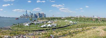
On May 24, 2012, Mayor Michael Bloomberg broke ground on the new park and public spaces designed by landscape architecture firm West 8, along with announcing the opening of the rehabilitated Castle Williams.[33] The Bloomberg administration's ten-year capital plan had provided funding for the first phase of construction, which began in the summer of 2012.[34] As part of phase 1 of the master plan:[34]
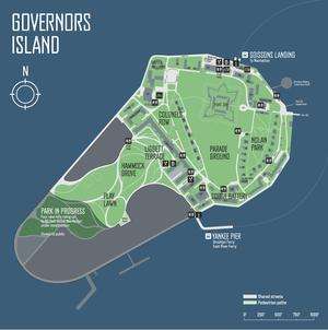
- Soissons Landing was upgraded to improve access to the island. The ferry docks were rehabilitated, the old ferry waiting room demolished and a new entry plaza completed in 2013.
- The Parade Ground would be re-graded for lawn sports.
- The Historic District would gain park amenities.
- A new potable water connection would be established and the seawall would be repaired. There had been no potable water since the island passed to city ownership in 2003, and the locally illegal connection from Brooklyn–Battery Tunnel was severed. Both year-long projects commenced in 2013.[28]
- As part of the South Island park, Liggett Terrace, a 6 acres (2.4 ha) courtyard with seasonal plantings near the Liggett Hall, would be added, as was Hammock Grove, a new shaded, wooded area containing hammocks for visitors and a Play Lawn will with 2 new baseball fields.[28] Work commenced in 2012 with demolition of 1960s and 1970s military housing complexes, and while both opened in late 2013, they were finished in early 2014.[35]
- A parking lot and road surrounding the historic fortification, South Battery, was converted into a lawn in 2013.
- Another 33 acres (13 ha) in that area may be rezoned for commercial use, including a hotel.[28]
On June 6, 2015, the Oyster Pavilion was set to open.[36] The 10-acre (4.0 ha) Hills section of the park was the last piece of the newly redeveloped island to open.[37] The Hills opened on July 21, 2016,[38] and consist of four hills that are 26 to 70 feet (7.9 to 21.3 m) high,[39] including a hill that contains four long slides.[40]
In July 2018, a glamorous camping, or "glamping", retreat was opened on Governors Island. The glamping facility was located on 6 acres of land and would be open through November 2018. Customers, or "glampers", would be allowed to use the island at 7 a.m., three hours before the island opened to the general public each day. There are several tiers of tent accommodations, as well as daily activities for glampers.[41][42]
Friends of Governors Island
Since the decision by the US Coast Guard to vacate the 172-acre (0.70 km2) island in 1995, the Governors Island Alliance and its 50 member organizations led a campaign to return the island to New York for public purposes.[43] Since 2014 the Alliance has been an independent non-profit. In 2016 it was renamed Friends of Governors Island. The Friends run volunteer and membership programs, raise money and perform advocacy for the island.
Public access
From its transfer in the years 2003 to 2015, Governors Island was open to the public on weekends during the summer. Now the island can be visited seven days a week from May 1 through October 31.
Starting in 2010, weekend ferry service commenced between Governors Island and Brooklyn Bridge Park's Pier 6 at Atlantic Avenue. On the island, passengers depart and arrive at Yankee Pier.[44] A summer Friday-only loop serves Governors Island, Manhattan, Atlantic Avenue, and Brooklyn Bridge Park.
In June 2011, NY Waterway started service to points along the East River.[45] On May 1, 2017, that route became part of the NYC Ferry's East River route, which runs between Pier 11/Wall Street in Manhattan's Financial District and the East 34th Street Ferry Landing in Murray Hill, Manhattan, with five intermediate stops in Brooklyn and Queens.[46][47] During summer weekends, Governors Island is an intermediate stop on the route between Pier 11 and Fulton Ferry.[48]
Access from Manhattan is from the Battery Maritime Building in the Financial District. The 1908 cast-iron structure, located next to the Staten Island Ferry terminal, was restored between 2001-2006.[49] Service is half-hourly. The departure and arrival dock on Governors Island is the Soissons Dock at the north tip of the island. The ride is about 7 minutes in duration. This ferry is only accessible during the late spring and the summer.[50]
Activities on the island include free National Park Service walking tours, bike riding, picnicking, art installations, fairs, drone races, festivals, and concerts. Bicycle, tandem, and quadcycle rental is provided on the island by Bike and Roll at hourly and daily rates.[51] New York Water Taxi operates an artificial beach on the northern tip of the island.[52] The island is roughly divided in half by a street called Division Road. The northeastern half is currently open to the public. The southwestern half, which contains the abandoned U.S. Coast Guard housing and service areas, is still in redevelopment and some sections remain closed to the public. However, three sections of the park are open: the southern end Picnic Point, the central Hammock Grove as of 2014, and The Hills on the southwestern corner as of 2016. The island's circumferential drive along the waterfront is also open to the public. Demolition of the U.S. Coast Guard housing began in 2008. It is on the grounds of the former Liberty Village housing area that was used by Coast Guard families between 1988 and 1996.[53] There are still Coast Guard buildings and barracks, not of historical significance, in areas yet to be redeveloped.
The Governors Island Art Fair has taken place annually on the island during weekends in September since 2007. Originally located in buildings on Colonel's Row, the event has grown to include Castle Williams and Fort Jay as artist venues. The 2015 season saw an expansion in the number and variety of exhibits, held in the former officers' quarters and other buildings, some redeveloped, some not.
The "World Trade Center Run to Remember" has been run annually on the island since 2009 on the first Sunday of September. The activities include a 5K Run, 3K Family Fun Run/Walk, Children's Fun Run, and other activities to benefit organizations associated with 9/11 related services.[54]
Notable people
- The Smothers Brothers were both born on Governors Island, where their father, Thomas B. Smothers, a U.S. Army officer, was stationed
- Janet Lambert, an author of young adult fiction, resided on Governors Island while her husband was the post commander in the 1950s
- Lois Lowry, author of The Giver, lived on Governors Island during her high school years while her father, an army dentist, was stationed there
- Michael Collins, NASA astronaut, called Governors Island home during a portion of his childhood
- Withers A. Burress, Commanding General of the 100th Division (United States) during World War II, finished his distinguished military career as commander of the First United States Army at Fort Jay from 1952-1954, receiving a ticker-tape parade in Lower Manhattan upon his retirement [55]
- Neal Adams, comic book and commercial artist, born on the Island[56]
- Harvey E. Brown, Jr., American military officer and army surgeon, born on the Island
- Courtney Hodges, continued command of First Army at Fort Jay after World War II
See also
References
Notes
- ↑ National Park Service (2007-01-23). "National Register Information System". National Register of Historic Places. National Park Service.
- 1 2 "Governors Island". National Historic Landmark summary listing. National Park Service. September 11, 2007.
- 1 2 Noted in Joseph White Moulton, History of the State of New York including its Aboriginal and Colonial Annals, 1824, excerpted in The New-York Literary Gazette, 1826.
- 1 2 "Governors Island". Governors Island. Archived from the original on January 6, 2012. Retrieved June 26, 2015.
- ↑ "GOVERNORS ISLAND". forgotten-ny.com. Retrieved June 26, 2015.
- ↑ Mixit Productions. "The New Amsterdam Trail - A Virtual Tour". nyharborparks.org. Retrieved June 26, 2015.
- ↑ "GovIsland named NYS birthplace, Legislature agrees to legacy". tolerancepark.org. Retrieved June 26, 2015.
- ↑ Henry L. Schoolcraft, "The Capture of New Amsterdam," English Historical Review (1907) 22#88 674–693 in JSTOR
- 1 2 3 4 5 6 7 8 9 10 11 12 13 "A Brief History of Governors Island". Governors Island National Monument (U.S. National Park Service). January 5, 2015. Retrieved November 19, 2015.
- ↑ Historic Timeline of The Battery - The Battery Conservancy Archived March 20, 2007, at the Wayback Machine.
- ↑ The Governor's House, Governors Island, Borough of Manhattan, New York Landmarks Preservation Commission, 1967; "now believe to be a full century youngwer" (Edwin G. Burrows, Forgotten Patriots: The Untold Story of American Prisoners During the Revolution 2010:323, note 42).
- ↑ Hickmann, H. Lanier, Jr. (2003). American alchemy: the history of solid waste management in the United States. ForesterPress. ISBN 978-0-9707687-2-8. , p. 269
- ↑ JSTOR 25121598
- ↑ "Governor's Island Tercentenary." New York National Guardsman. August 1937.
- ↑ Abandoned & Little-Known Airfields: New York City, Brooklyn
- ↑ Hightower, Barbara & Higgins, Blanche (1983). "Governors Island: National Register of Historic Places Inventory-Nomination". National Park Service.
- ↑ "National Register of Historic Places Inventory: Governors Island—Accompanying 76 photos, from 1982". National Park Service. 1983.
- ↑ "Governors Island Accord". July 3, 1993. Retrieved January 20, 2010.
- ↑ "New Globe Theater". newglobe.org. Retrieved June 26, 2015.
- ↑ "Gotham Center Discussion Boards". gothamcenter.org. Archived from the original on February 23, 2015. Retrieved June 26, 2015.
- 1 2 3 Ouroussoff, Nicolai (December 20, 2007). "A Landscape's Isolation Is Turned Into a Virtue". The New York Times. Retrieved May 20, 2009.
- 1 2 Ouroussoff, Nicolai (June 20, 2007). "Competing Visions for Governors Island". The New York Times. Retrieved July 20, 2007.
- 1 2 3 4 Robin Pogrebin (December 20, 2007). "Park Plan is Chosen for Governors Island". New York Times. Retrieved August 25, 2007.
- ↑ "ASLA 2012 Professional Awards - Governors Island Park and Public Space Master Plan". asla.org. Retrieved June 26, 2015.
- ↑ "West 8 creates artificial hills on New York's Governors Island". Dezeen. 2016-07-01. Retrieved 2017-06-13.
- ↑ Shapiro, Julie (May 22, 2008). "David Byrne hooks up Battery Building to an organ". Downtown Express. New York. Retrieved January 23, 2009.
- ↑ http://graphics8.nytimes.com/images/2006/02/23/arts/gov.span.jpg
- 1 2 3 4 "On Governors Island, Many Visitors but Few Tenants". The Wall Street Journal. August 19, 2014. Retrieved August 24, 2014.
- ↑ Jennifer 8. Lee (June 22, 2009). "On Governors I., an Organic Farm With a View". The New York Times. Retrieved September 21, 2009.
- ↑ Pogrebin, Robin (March 22, 2010). "N.Y.U. Plans to Expand Campuses by 40 Percent". The New York Times. Retrieved April 12, 2010.
- ↑ Ouroussoff, Nicolai (April 12, 2010). "Governors Island Vision Adds Hills and Hammocks". The New York Times. Retrieved April 15, 2010.
- ↑ Satow, Julie (November 22, 2011). "Visions of LoLo, a Neighborhood Rising from Landfill". The New York Times. Retrieved November 23, 2011.
- ↑ "Mayor Bloomberg and Officials Break Ground on New Governors Island Park and Public Spaces and Re-open Castle William" .
- 1 2 "Governors Island". Governors Island. Archived from the original on March 10, 2015. Retrieved June 26, 2015.
- ↑ Jessica Dailey (October 28, 2013). "West 8 Creates A Flood-Resistant Park On Governors Island". Curbed. Retrieved June 4, 2015.
- ↑ Wendy Goodman (June 4, 2015). "Inside Governors Island's New Oyster Pavilion". New York Magazine. Retrieved June 4, 2015.
- See also: Oyster Pavilion official website
- ↑ Jessica Dailey (May 5, 2015). "The Hills Are Coming to Life on Governors Island". Curbed. Retrieved June 4, 2015.
- ↑ "New York City Turns an Abandoned Military Base Into a Sprawling Public Park". Slate. July 22, 2016. ISSN 1091-2339. Retrieved July 29, 2016.
- ↑ Matthews, Karen (July 18, 2016). "New Hills on Governors Island Offer Spectacular Views". NBC New York. Associated Press. Retrieved July 29, 2016.
- ↑ Fermino, Jennifer (July 19, 2016). "The Hills, an extraordinary $71M park, opens on Governors Island". New York Daily News. Retrieved July 29, 2016.
- ↑ "What to expect if you go 'glamping' on Governors Island". am New York. 2018-07-14. Retrieved 2018-07-18.
- ↑ Carlson, Jen (July 13, 2018). "Inside The New Glamping Tents On Governors Island". Gothamist. Archived from the original on July 14, 2018. Retrieved July 18, 2018.
- ↑ Governors Island Alliance Archived June 8, 2008, at the Wayback Machine.
- ↑ "The Trust for Governors Island - Visit the Island - Directions & Ferry Schedule". Govisland.com. Archived from the original on September 10, 2014. Retrieved August 21, 2014.
- ↑ Grynbaum, Michael M.; Quinlan, Adriane (June 13, 2011). "East River Ferry Service Begins". The New York Times. ISSN 0362-4331. Retrieved September 23, 2016.
- ↑ "NYC launches ferry service with Queens, East River routes". NY Daily News. Associated Press. May 1, 2017. Archived from the original on May 1, 2017. Retrieved May 1, 2017.
- ↑ Levine, Alexandra S.; Wolfe, Jonathan (May 1, 2017). "New York Today: Our City's New Ferry". The New York Times. ISSN 0362-4331. Retrieved May 1, 2017.
- ↑ "Routes and Schedules: East River". NYC Ferry.
- ↑ Lower Manhattan: Battery Maritime Building Archived November 1, 2008, at the Wayback Machine.
- ↑ Venugopal, Nikhita. "Officials Weigh Governors Island Stop on Citywide Ferry Route". DNAinfo New York. 2016-09-12. Archived from the original on September 24, 2016. Retrieved September 23, 2016.
- ↑ "Governors Island Bike Rentals - New York - Bike and Roll". Archived from the original on October 26, 2010. Retrieved June 20, 2010.
- ↑ "Water Taxi Beach - Governors Island". Archived from the original on July 22, 2010. Retrieved June 20, 2010.
- ↑ Chan, Sewell (October 9, 2008). "Invitation to a Demolition, on Governors Island". The New York Times City Room Blog.
- ↑ (WTCRTR)
- ↑ Downtown Alliance Commemorates 204 Canyon of Heroes Parades. Alliance for Downtown New York, Inc. Accessed October 8, 2017
- ↑ Schepens, Beth (2003). "Army Brats Recall Island Paradise — Sidebar: Governors Island Factoids". NYC24.org. Archived from the original on January 31, 2009.
Sources

Further reading
- Boggs, Kenneth L. Sentinel isle; a brief history of Governors Island, Fort Jay, 1637-1950. Published 1950
- Guide to Governors Island. Edited by United States Coast Guards (1973)
- Buttenwieser, Ann L. Governors Island: The Jewel of New York Harbor. Syracuse University Press, 2009. ISBN 978-0-8156-0936-0
- Smith, Edmund Banks. Governors Island, its military history under three flags, 1637-1922 Publisher: Valentine's Manual New York, 1923
- Cultural Landscape Report for Governors Island National Monument by Liza Novak. The National Park Service, Boston, Massasuchetts 2010
External links
| Wikimedia Commons has media related to Governors Island. |
Official websites:
- The Trust for Governors Island website
- The Governors Island National Monument website
- Governors Island Visitor information
- Governors Island Alliance
Other websites:
- Governors Island Art Fair
- Biking on Governors Island
- Cultural Landscape Report for Governors Island National Monument
- Governors Island, Lifeblood of American Liberty (34 slides)
- National Historic Landmark information
- Governors Island Military Brats—a site made by some raised on the island
- Enlargement And Reconstruction of Governors Island's Military Post
- Photos of Governor's Island

