Morningside Heights, Manhattan
| Morningside Heights | |
|---|---|
| Neighborhood of Manhattan | |
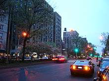
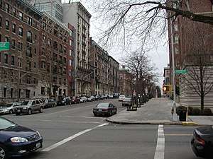 Residential buildings on West 116th Street opposite Columbia University | |
| Coordinates: 40°48′37″N 73°57′24″W / 40.810201°N 73.956601°WCoordinates: 40°48′37″N 73°57′24″W / 40.810201°N 73.956601°W | |
| Country |
|
| State |
|
| City |
|
| County/Borough | New York/Manhattan |
| Area[1] | |
| • Total | 1.22 km2 (0.472 sq mi) |
| Population (2010)[2] | |
| • Total | 55,929 |
| • Density | 46,000/km2 (120,000/sq mi) |
| ZIP codes | 10024, 10025, 10027 |
| Area code | 212, 332, 646, and 917 |

Morningside Heights is a neighborhood of the borough of Manhattan in New York City, on the border of the Upper West Side and Harlem.[3][4][5][6][7][8][9]
Morningside Heights is bounded by Morningside Park at Morningside Drive to the east, Manhattanville at 125th Street to the north, Manhattan Valley at 110th Street to the south, and Riverside Park at Riverside Drive to the west.[10][11] The main thoroughfare is Broadway.
It is chiefly known as the home of educational and cultural institutions such as Columbia University, Teachers College, Barnard College, the Manhattan School of Music, Bank Street College of Education, "Grant's Tomb", Union Theological Seminary in the City of New York and the Jewish Theological Seminary of America. Additionally, Morningside Heights contains a number of religious institutions, including the Cathedral of Saint John the Divine, Riverside Church, the Church of Notre Dame, Corpus Christi Church, the Broadway Presbyterian Church and Interchurch Center. The neighborhood is also home to St. Luke's Hospital. Most of the neighborhood is part of New York's 10th congressional district since 2013.[12]
In 2017, the New York City Landmarks Preservation Commission created the Morningside Heights Historic District. The district includes 115 residential and institutional properties on West 109th Street west of Broadway, east and west of Broadway from Cathedral Parkway to West 113th Street, west of Broadway from West 113th Street to 118th Street, and west of Claremont Avenue from West 118th to 119th Street.[13]
History
In the 17th century, the land that is now Morningside Heights was known as Vandewater's Heights, named for the landowner.[3] On September 16, 1776, the Battle of Harlem Heights was fought in Morningside Heights, with the most intense fighting occurring in a sloping wheat field that is now the location of Barnard College. A plaque by the Columbia University gate on 117th Street and Broadway commemorates this battle.[14]
Use of the name "Morningside Heights" for the neighborhood arose in the 1890s when development of the area commenced. The name "Bloomingdale" – which referred to part of the present-day neighborhood of Manhattan Valley, located to the south – was also used for the area around the Bloomingdale Insane Asylum, which was located at the present location of the main campus of Columbia University. However, other names such as "Morningside Hill" and "Riverside Heights" were used for the area.[15] No single name was commonly used for the neighborhood by the time Columbia University, Teachers College, the Cathedral of Saint John the Divine, and St. Luke's Hospital started construction.
Two names eventually gained the most use; "Morningside Heights" was preferred by the two colleges, while "Cathedral Heights" was preferred by St. John's and St. Luke's. After about 1898, "Morningside Heights" became the most generally accepted, although the diocese at St. John's continued to call the neighborhood Cathedral Heights well into the 20th century. The term "Morningside" came from the park on the east flank of the plateau, which was lit up by the rising sun and which was called "Morning Side Park" in 1870 when the city parks commissioner recommended a survey of the land.[11]

Many apartment buildings and rowhouses, amongst the first to use elevators in residential buildings, were built for New York's prosperous middle class in the first two decades of the twentieth century and most of these buildings are still extant.[11] By the mid-20th century the increasing prevalence of Single Room Occupancy (S.R.O.) hotels led to attendant socioeconomic problems and a decline in the neighborhood. Jane Jacobs The Death and Life of Great American Cities presented the neighborhood as a key example of the failure of the urban planning techniques of the era. In 1947 David Rockefeller became involved in a major middle-income housing development when he was elected as chairman of Morningside Heights Inc. by fourteen major institutions that were based in the area, including Columbia University. In 1951 the organization developed Morningside Gardens, a six-building apartment complex to house middle-income families from all ethnic backgrounds. Morningside Gardens, an experimental co-op project, opened in 1957 between 123rd and LaSalle Streets, Broadway, and Amsterdam Avenue.
Social problems in the area prompted Columbia to purchase much of the neighborhood's real estate, leading to accusations of forced eviction and gentrification. This process reached its nadir in 1968, when protests erupted in both the neighborhood and on Columbia's campus over the university's proposal to build a gym in Morningside Park. Residents alleged that the park's proposed separate entrance for Harlem residents on the lower level of the park was segregated, and that public park space was being annexed by a wealthy private institution. The university was eventually forced to abandon the plan. However, Columbia University has still expanded its presence in the neighborhood markedly over the last few decades, and gentrification and urban renewal have proceeded apace. In January 2008 the university received approval from the City Council to expand significantly in nearby Manhattanville.[16]
Since the late 1990s, some businesses in the area started using the name SoHa (or "South of Harlem") to refer to the neighborhood, as seen in the names of Max's SoHa restaurant and the former SoHa nightclub in Morningside Heights.[15][17]
Demographics
Based on data from the 2010 United States Census, the population of Morningside Heights was 55,929, an increase of 1,721 (3.2%) from the 54,208 counted in 2000. Covering an area of 465.11 acres (188.22 ha), the neighborhood had a population density of 120.2 inhabitants per acre (76,900/sq mi; 29,700/km2).[2]
The racial makeup of the neighborhood was 46.0% (25,750) White, 13.6% (7,619) African American, 0.2% (105) Native American, 13.3% (7,462) Asian, 0.1% (30) Pacific Islander, 0.4% (203) from other races, and 2.9% (1,605) from two or more races. Hispanic or Latino of any race were 23.5% (13,155) of the population.[18]
Sites of interest
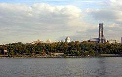
The label Academic Acropolis has been used to describe the area, which sits on a high natural point in Manhattan and contains numerous academic institutions.[19] Much of the neighborhood is the campus of Columbia University, and the university owns a large amount of non-campus real estate. Other educational institutions in the neighborhood include Barnard College, Union Theological Seminary, New York Theological Seminary, Jewish Theological Seminary of America, Manhattan School of Music, Teachers College, Bank Street College of Education, St. Hilda's & St. Hugh's School, The School at Columbia University, Bank Street School for Children, The Cathedral School of St. John the Divine, and for the younger residents, Columbia Greenhouse nursery school.[20] NASA's Goddard Institute for Space Studies is also located in the neighborhood, directly above Tom's Restaurant in a building owned by Columbia University.
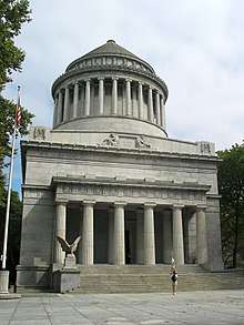
Non-academic landmarks in Morningside Heights include the Cathedral Church of Saint John the Divine, Grant's Tomb, Riverside Church, Interchurch Center, Corpus Christi Church, International House, and St. Luke's-Roosevelt Hospital Center.
In popular culture
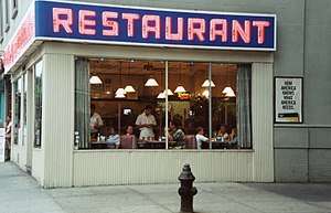
Tom's Restaurant, on Broadway at 112th Street, was featured in the 1980s song "Tom's Diner" by Suzanne Vega, an alumna of Barnard College.[21] Later, exterior shots were used on the television sitcom Seinfeld as a stand-in for the diner hangout of the show's principal characters. Further north, the West End Bar served especially as a meeting place for writers of the Beat Generation in the 1940s/1950s, as well as for student activists prior to, during, and after the Columbia University protests of 1968. The bar's jazz room was run by jazz historian and DJ Phil Schaap for 17 years. In the late 2000s, the establishment was absorbed into a Cuban restaurant chain, Havana Central, and became known as Havana Central at the West End, until the restaurant closed in 2015. It then became the grill restaurant, Bernheim and Schwartz, which closed in April 2017.
Transportation

The area is served by the New York City Subway at the Cathedral Parkway – 110th Street and 116th Street – Columbia University stations of the New York City Subway's IRT Broadway – Seventh Avenue Line (1 train). New York City Bus service includes the M4, M5, M11, M60 SBS, M100 routes.
Politics
The neighborhood is divided between the 69th and 70th Assembly Districts, with the 69th represented by Democrat Daniel O'Donnell and the 70th represented by Democrat Inez Dickens, in the State Assembly.[22][23] In the State Senate, the neighborhood is split between the 30th District, represented by Democrat Brian Benjamin, and the 31st District, represented by Democrat Marisol Alcantara.[24][25] In the City Council, the neighborhood is part of the 7th District, represented by Mark Levine.[26]
In Congress, the neighborhood was part of the district represented by Jerrold Nadler until 2002 redistricting moved it into Charles Rangel's Harlem-based district. The 2012 redistricting process moved the bulk of Morningside Heights into the new 10th Congressional District, represented by Nadler.[27]
Education
The New York City Department of Education operates public schools.
As of 2015 Public School 36, the Margaret Douglas School, has a student body that is 96% black and Hispanic. The median income of its students' families was $36,000. These demographics are less wealthy and have fewer Whites compared to the overall neighborhood demographics.[28]
Notable residents
- Comedian George Carlin grew up on West 121st Street; the block of 121st Street where he lived was dedicated to him in October 2014.[29] In the comedy piece "White Harlem", which appears on his Occupation: Foole album, he said that younger residents would refer to the neighborhood as "White Harlem". This term is heard in "Brooklyn Without Limits", a 2010 episode of the comedy 30 Rock.
- Film director Cecil B. DeMille lived on West 114th Street between Broadway and Riverside Drive.[30]
- F. Scott Fitzgerald lived at 200 Claremont Ave. while working in advertising and writing This Side of Paradise.[31]
- George Gershwin began composing his Rhapsody in Blue while living at 501 West 110th Street.[30]
- Writer Allen Ginsberg lived at 536 West 114th Street.[30]
- Novelist Jack Kerouac lived at 421 West 118th Street.[30]
- Thurgood Marshall, the first African-American Supreme Court justice, lived in Morningside Gardens.[30]
- Harlan Fiske Stone, who later became the Chief Justice of the United States, lived at 435 Riverside Drive while serving as Dean of Columbia Law School.[32]
- Harry Houdini, a former Houdini home, purchased in 1908, at 278 West 113th Street that displays artifacts.[33][34] It should not be confused with "The House of Houdini", a museum in Budapest.
References
Notes
- ↑ http://www.city-data.com/neighborhood/Morningside-Heights-New-York-NY.html
- 1 2 Table PL-P5 NTA: Total Population and Persons Per Acre - New York City Neighborhood Tabulation Areas*, 2010, Population Division - New York City Department of City Planning, February 2012. Accessed June 16, 2016.
- 1 2 Jackson, Kenneth T., ed. (1995), The Encyclopedia of New York City, New Haven: Yale University Press, ISBN 0300055366
- ↑ Nishanth Gopinathan. "Morningside Heights, Manhattan New York City".
- ↑ Adam Shepard (November 11, 2007). "The Dish: Five Guys, Lunetta, Community Food, ilili, Mason Dixon, Blue Ribbon Sushi". Eater NY. Retrieved May 12, 2011.
- ↑ "No Longer Majority Black, Harlem Is in Transition", New York Times, January 5, 2010.
- ↑ "District Profiles - New York City Department of City Planning".
- ↑ "Upper West Side - New York City Neighborhood - NYC".
- ↑ "Morningside Heights, Manhattan, Real Estate Buying Guide".
- ↑ "Neighborhood Profile", nymag.com; accessed February 6, 2018.
- 1 2 3 Dolkart, Andrew S. (1998). Morningside Heights: A History of its Architecture and Development. New York: Columbia University Press. ISBN 0-231-07850-1.
- ↑ "File:New York US Congressional District 10 (since 2013).tif", Wikimedia Commons. Map of boundaries for New York’s 10th United States Federal Congressional District
- ↑ Percival, Marianne S. et al.; McHale, Kate Lemos and Caratzas, Michael (eds.) (February 21, 2017) Morningside Heights Historic District Designation Report New York City Landmarks Preservation Commission
- ↑ "The 1776 Battle of Harlem Heights Was Fought at Modern Day Columbia University". Untapped Cities.
- 1 2 Leslie Albrecht (May 1, 2012). "From Bloomingdale to SoHa: One UWS Neighborhood's Quest for a Name". DNA Info. Archived from the original on December 24, 2014. Retrieved December 24, 2014.
- ↑ "[Untitled]" (Press release). Columbia University/Manhattanville in West Harlem. December 19, 2007. Retrieved 2014-01-01.
- ↑ Nina Siegal (October 31, 1999). "Suddenly Hot: Uptown Has Its SoHa". New York Times. Retrieved December 24, 2014.
- ↑ Table PL-P3A NTA: Total Population by Mutually Exclusive Race and Hispanic Origin - New York City Neighborhood Tabulation Areas*, 2010, Population Division - New York City Department of City Planning, March 29, 2011. Accessed June 14, 2016.
- ↑ Morningside Heights, nyc.com (unaffiliated with nyc.gov)
- ↑ "Columbia Greenhouse Nursery School".
- ↑ Vega, Suzanne (September 23, 2008). "Tom's Essay". The New York Times. Retrieved February 6, 2018.
- ↑ New York State Assembly - Member Section, Assembly.state.ny.us; retrieved on 2013-09-07.
- ↑ "New York State Assembly - Keith L.T. Wright".
- ↑ District 30|New York State Senate, Nysenate.gov; retrieved 2013-09-07.
- ↑ District 31|New York State Senate, Nysenate.gov; retrieved 2013-09-07.
- ↑ "District 7 - New York City Council". New York City Council. Retrieved 3 March 2018.
- ↑ New congressional districts shape Rangel race, moving Columbia out of district, Columbiaspectator.com; retrieved 2013-09-07.
- ↑ Harris, Elizabeth A. (2015-12-16). "School Segregation Persists in Gentrifying Neighborhoods, Maps Suggest". The New York Times. Retrieved 2017-07-03.
- ↑ George Carlin Way, nbvcnewyork.com; accessed April 6, 2015.
- 1 2 3 4 5 Hohol, Barbara,; Arbo, Jack, eds. "Famous Morningside Heights Residents (At One Time Or Another)". West 112th Street Block Association. Retrieved April 23, 2015.
- ↑ "A Fitzgerald Chronology, University of South Carolina". February 1919. Retrieved 2014-06-11.
- ↑ Bunyan, Patrick (1999). All Around the Town: Amazing Manhattan Facts and Curiosities. Fordham University Press. p. 306. ISBN 978-0823219414.
- ↑ Cox, John (January 17, 2011). "Discovering 278: the home of Houdini". Wild About Harry. Retrieved January 22, 2017.
... I certainly knew the famous address -- “278” which is how Houdini always referred to his Harlem home.
- ↑ "Houdini's Homes: Houdini owned homes in New York and California". magictricks.com. Retrieved January 23, 2017.
Bibliography
- Hopper Striker Mott. The New York of Yesterday: A Descriptive Narrative of Old Bloomingdale. 1908.
- "Neighborhood Profile: Morningside Heights", New York Magazine Real Estate (online).
External links
- Morningside Heights Historic District Committee
- Morningside Heights Digital History (Columbia University Libraries)
| Lower Manhattan below 14th St (CB 1, 2, 3) |
|   |
|---|---|---|
| Midtown (CB 5) | ||
| West Side (CB 4, 7) | ||
| East Side (CB 6, 8) | ||
| Upper Manhattan above 110th St (CB 9, 10, 11, 12) | ||
| Islands |
| |
| Former | ||