Bushwick, Brooklyn
| Bushwick, Brooklyn | |
|---|---|
| Neighborhood of Brooklyn | |
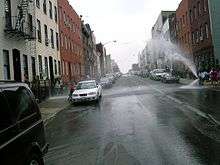
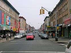 Knickerbocker Avenue in 2006; it is a main shopping street south of Maria Hernandez Park. | |
| Country |
|
| State |
|
| City |
|
| Borough |
|
| Area[1] | |
| • Total | 6.1 km2 (2.34 sq mi) |
| Population (2010)[1] | |
| • Total | 129,239 |
| • Density | 21,000/km2 (55,000/sq mi) |
| Ethnicity[2] | |
| • White (non-Hispanic) | 9.4% |
| • Black | 18.5% (non-Hispanic) |
| • Hispanic or Latino | 67.0% |
| • Asian | 3.9% |
| • Other | 1.1% |
| Economics | |
| • Median income | $33,162 |
| ZIP codes | 11206, 11207, 11221, 11237 |
| Area code | 718, 347, 929, and 917 |
Bushwick is a working-class neighborhood in the northern part of the New York City borough of Brooklyn. The town was first founded by Europeans during the Dutch colonization of the Americas in the 17th century. In the 19th century, the neighborhood became a community of Germanic immigrants and their descendants; by the late 20th century, it became predominantly Hispanic as another wave of immigrants arrived. Formerly Brooklyn's 18th Ward, the neighborhood is now part of Brooklyn Community Board 4. It is policed by the NYPD's 83rd Precinct and is represented in the New York City Council as part of Districts 34 and 37.[3][4][5]
Bushwick shares a border with Ridgewood, Queens, to the northeast, and is bounded by the Brooklyn neighborhoods of Williamsburg to the northwest; East New York and the cemeteries of Highland Park to the southeast; Brownsville to the south; and Bedford-Stuyvesant to the southwest.[6] It is served by ZIP codes 11206, 11207, 11221, and 11237.[7] Bushwick was once an independent town and has undergone various territorial changes throughout its history.
Geography
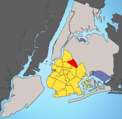
Neighborhoods in New York do not have official boundaries; informal boundaries are often contested, and this has been the case with Bushwick. However, the boundaries of Bushwick are often given as those of Brooklyn Community Board 4, which is delineated by Flushing Avenue on the north, Broadway on the southwest, the border with Queens to the northeast, and the Cemetery of the Evergreens on the southeast.
The industrial area north of Flushing Avenue, east of Bushwick Avenue, and south of Grand Street is also commonly included in Bushwick, occasionally with the modifier "Industrial Bushwick".[8][9]
The village of Bushwick—which, along with Breukelen and Bedford, became incorporated as the city of Brooklyn on January 1, 1854—included present-day Williamsburg and Greenpoint.[10][11] Prior to the merger, in the early 19th century, residential development in the area had begun when the new district of Williamsburg was laid out in western Bushwick. Williamsburg was incorporated in 1827 and officially severed from Bushwick in 1839.[10]
The centroid, or geographic center, of New York City's five boroughs is in Bushwick "on Stockholm Street between Wyckoff Avenue and St. Nicholas Avenue".[12][13]
Statistics
Demographics
Bushwick's population in 2010 was 129,239.[2] Though an ethnic neighborhood, Bushwick's population is, for a New York City neighborhood, relatively heterogeneous, scoring a 0.5 on the Furman Center's racial diversity index, making it the city's 35th most diverse neighborhood in 2007. Most residents are Latino American citizens from the island of Puerto Rico and immigrants from the Dominican Republic. Since the turn of the 21st century, the population of native-born Americans has increased, as have other Latino groups, particularly immigrants from Mexico and El Salvador. In 2008 the neighborhood's median household income was $28,802. 32% of the population falls under the poverty line, making Bushwick the 7th-most impoverished neighborhood in New York City. More than 75% of children in the neighborhood are born in poverty.[14] Some 40.3% of students in Bushwick read at grade level in 2007, making it the 49th most literate neighborhood in the city that year. 58.2% of students could work math at grade level in Bushwick, and it ranked as 41st in the city. In 2007, Bushwick averaged 25 felonies per 1,000 persons, making it the 25th most felonious of the city's 55 community districts.[15]
Bushwick is the most populous Hispanic-American community in Brooklyn, although Sunset Park also has a large Hispanic population. As in other neighborhoods in New York City, Bushwick's Hispanic population is mainly from Puerto Rico and the Dominican Republic. It also has a sizable population from South American nations. As nearly 70% of Bushwick's population is Hispanic, residents have created many businesses to support their various national and distinct traditions in food and other items. The neighborhood's major commercial streets are Knickerbocker Avenue, Myrtle Avenue, Wyckoff Avenue, and Broadway.
Bushwick North
Based on data from the 2010 United States Census, the population of Bushwick North was 57,138, an increase of 1,045 (1.9%) from the 56,093 counted in 2000. Covering an area of 570.78 acres (230.99 ha), the neighborhood had a population density of 100.1 inhabitants per acre (64,100/sq mi; 24,700/km2).[1]
The ethnic and racial makeup of the neighborhood as of 2010 was 10.7% (6,098) non-Hispanic white, 9.7% (5,533) non-Hispanic black, 0.1% (82) Native American, 6.0% (3,417) Asian, 0.0% (11) Pacific Islander, 0.7% (380) from other races, and 1.0% (582) from two or more races. Hispanic or Latino of any race were 71.8% (41,035) of the population.[16]
Bushwick South
Based on data from the 2010 United States Census, the population of Bushwick South was 72,101, an increase of 7,484 (11.6%) from the 64,617 counted in 2000. Covering an area of 923.64 acres (373.78 ha), the neighborhood had a population density of 78.1 inhabitants per acre (50,000/sq mi; 19,300/km2).[1]
The racial makeup of the neighborhood was 9.5% (6,819) non-Hispanic white, 28.1% (20,281) black, 0.2% (155) Native American, 2.4% (1,734) Asian, 0.0% (21) Pacific Islander, 0.4% (268) from other races, and 1.1% (809) from two or more races. Hispanic or Latino of any race were 58.3% (42,014) of the population.[16]
Puerto Rican and Dominican communities
As mentioned in the section before, Bushwick as well as neighboring East New York are the center for the Hispanic community in Brooklyn.[17] In the post-World War II period, Bushwick was still a predominantly Irish and Italian-American community. Puerto Ricans began to migrate to New York for greater opportunities, developing Hispanic enclaves in Brooklyn, East Harlem, the Upper West Side, and the Bronx. Many Puerto Ricans also settled in neighboring Williamsburg, also known as Los Sures, due to the proximity to jobs at the now defunct Domino Sugar Refinery as well as at the Brooklyn Navy Yard; they expanded into other parts of Brooklyn as ethnic Irish and Italians moved to suburbs in Queens and Nassau County.[18][19]
The sounds of salsa, corner bodegas, and Latin cuisine are part of the cultural dynamic of the Bushwick community.[20] It is the largest concentration of Hispanic Americans in the entire borough, followed closely behind by Sunset Park. Politically, Bushwick is part of New York's 7th congressional district and is represented in Congress by Puerto Rican born Nydia Velázquez, whose office is in neighboring Williamsburg as well as in Downtown Brooklyn.[21] Velázquez was the first woman of Hispanic and Puerto Rican descent to be elected to the United States Congress.
The Williamsburg and Bushwick communities are home to their own local Puerto Rican Day Parade.[22] The parade board usually meets at the Orocovis Social Club, located off Myrtle Avenue. La Isla Restaurant, located off Myrtle Avenue and Knickerbocker, is popular for its Puerto Rican and Dominican cuisine.[23][24][25] On the corner of Broadway, Flushing Avenue and Graham Avenue, where Bushwick, Williamsburg and Bedford–Stuyvesant meet, in the shadow of Woodhull Medical Center, Graham Avenue becomes the Avenue of Puerto Rico.[26]
Located here is a campus of Boricua College and a branch of the Puerto Rico-based Popular Community Bank. This territory is disputed, as local residents claim it falls within Bushwick, while others argue that it is part of Williamsburg. Make the Road New York, a Latino community group, has a chapter in the neighborhood.[27] So important is the activism of local Latinos that in 2016, Democratic presidential candidate Bernie Sanders campaigned in Bushwick in order to reach Hispanic votes.[28][29] A web show, East Willy B, was created to explore the struggles of the local Latino community. Another notable shop is the Kikiriki Vivero, located on Myrtle Avenue, a Puerto Rican-style butcher shop that sells live poultry. It is known for its multi-color neon light signs.[30]
In both the New York State Senate and City Council, Bushwick is represented by Latinos: Martin Malave Dilan of Puerto Rican descent in the State Senate and Antonio Reynoso of Dominican American descent. in City Council.[31][32] Diana Reyna, who formerly represented the area in City Council, served as deputy borough President of Brooklyn, under Eric Adams.[20]
Housing
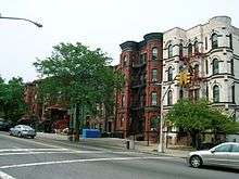
Bushwick's diverse housing stock includes six-family apartment buildings and two- and three-family townhouses. The median age of the housing stock is 76 years. More than 91% of housing units are within a quarter mile of a park, and over 97% of housing units are within half a mile of a subway. Bushwick is the site of many public housing projects, that house many lower income residents and are run by the New York City Housing Authority, including the Bushwick Houses, Hope Gardens which has many subsections, as well as Borinquen Plaza, The Palmetto Gardens and Bushwick II just to name a couple.[33][34]
Median rent in 2007 was $795, the 40th-highest in the city. About one in six rental units is subsidized, and greater than one in three units is rent regulated. 4% of renters live in severely overcrowded conditions. Vacant land occupies 4.1% of Bushwick, ranking it as the 21st-most vacant neighborhood in the city.
In 2007, the neighborhood had an 18.7% homeownership rate. Roughly 1 in 20 owners of 1–4 unit buildings received a notice of foreclosure.[15]
Between 1990 and 2014, rental costs in Bushwick increased by 44%, the fourth-highest rise in New York City.[35]
History
Bushwick township
| New Netherland series |
|---|
| Exploration |
| Fortifications: |
| Settlements: |
| The Patroon System |
|
| People of New Netherland |
| Flushing Remonstrance |
 |
In 1638, the Dutch West India Company secured a deed from the local Lenape people for the Bushwick area, and Peter Stuyvesant chartered the area in 1661, naming it Boswijck, meaning "little town in the woods" or "heavy woods" in 17th-century Dutch.[36][37] Its area included the modern-day communities of Bushwick, Williamsburg, and Greenpoint. Bushwick was the last of the original six Dutch towns of Brooklyn to be established within New Netherland.
The community was settled, though unchartered, on February 16, 1660, on a plot of land between the Bushwick and Newtown Creeks[36] by fourteen French and Huguenot settlers, a Dutch translator named Peter Jan De Witt,[38] and one of the original eleven slaves brought to New Netherland, Franciscus the Negro, who had worked his way to freedom.[39][40] The group centered their settlement on a church located near today's Bushwick and Metropolitan Avenues. The major thoroughfare was Woodpoint Road, which allowed farmers to bring their goods to the town dock.[41] This original settlement came to be known as Het Dorp by the Dutch, and, later, Bushwick Green by the British. The English would take over the six towns three years later and unite them under Kings County in 1683.
Many of Bushwick's Dutch records were lost after its annexation by Brooklyn in 1854.[42] Contemporary reports differ on the reason: T. W. Field writes that "a nice functionary of the [Brooklyn] City Hall ... contemptuously thrust them into his waste-paper sacks",[43] while Eugene Armbruster claims that the movable bookcase containing the records "was coveted by some municipal officer, who turned its contents upon the floor".[44]
At the turn of the 19th century, Bushwick consisted of four villages: Green Point, Bushwick Shore[45] (later known as Williamsburg), Bushwick Green, and Bushwick Crossroads (at the spot where today's Bushwick Avenue turns southeast at Flushing Avenue).[46]
Bushwick's first major expansion occurred after it annexed the New Lots of Bushwick, a hilly upland originally claimed by Native Americans in the first treaties they signed with European colonists granting the settlers rights to the lowland on the water. After the second war between the natives and the settlers broke out, the natives fled, leaving the area to be divided among the six towns in Kings County. Bushwick had the prime location to absorb its new tract of land in a contiguous fashion. New Bushwick Lane (Evergreen Avenue), a former Native American trail, was a key thoroughfare for accessing this new tract, which was suitable mostly for potato and cabbage agriculture.[47] This area is bounded roughly by Flushing Avenue to the north and Evergreen Cemetery to the south. In the 1850s, the New Lots of Bushwick area began to develop. References to the town of Bowronville, a new neighborhood contained within the area south of Lafayette Avenue and Stanhope Street, began to appear in the 1850s.[48][49]
The area known as Bushwick Shore was so called for about 140 years. Bushwick residents called Bushwick Shore "the Strand", another term for "beach".[50] Bushwick Creek, in the north, and Cripplebush, a region of thick, boggy shrubland extending from Wallabout Creek to Newtown Creek, in the south and east, cut Bushwick Shore off from the other villages in Bushwick. Farmers and gardeners from the other Bushwick villages sent their goods to Bushwick Shore to be ferried to New York City for sale at a market located at the present-day Grand Street. Bushwick Shore's favorable location close to New York City led to the creation of several farming developments. Originally a 13-acre (53,000 m2) development within Bushwick Shore, Williamsburgh rapidly expanded during the first half of the 19th century and eventually seceded from Bushwick to form its own independent city in 1852.[51] Both Bushwick and Williamsburgh were annexed to the City of Brooklyn in 1854.[42]
Early industry
When Bushwick was founded, it was primarily an area for farming food and tobacco. As Brooklyn and New York City grew, factories that manufactured sugar, oil, and chemicals were built. The inventor Peter Cooper built a glue manufacturing plant, his first factory, in Bushwick. Immigrants from western Europe joined the original Dutch settlers. The Bushwick Chemical Works, at Metropolitan Avenue and Grand Street on the English Kills channel, was another early industry among the lime, plaster, and brick works, coal yards, and other factories that developed along English Kills, which was dredged and made an important commercial waterway.[52] In October 1867, the American Institute awarded Bushwick Chemical Works the first premium for commercial acids of the greatest purity and strength.[53] The Bushwick Glass Company, later known as Brookfield Glass Company, established itself in 1869, when a local brewer sold it to James Brookfield.[54] It made a variety of bottles and jars.
In the 1840s and 1850s, a majority of the immigrants were German, which became the dominant population. Bushwick established a considerable brewery industry, including "Brewer's Row"—14 breweries operating in a 14-block area—by 1890.[55] Thus, Bushwick was dubbed the "beer capital of the Northeast". The last Bushwick brewery closed its doors in 1976.[56]
As late as 1883, Bushwick maintained open farming land east of Flushing Avenue.[57] A synergy developed between the brewers and the farmers during this period, as the dairy farmers collected spent grain and hops for cow feed. The dairy farmers sold milk and other dairy products to consumers in Brooklyn. Both industries supported blacksmiths, wheelwrights, and feed stores along Flushing Avenue.[58]
Railway hub

In 1868, the Long Island Rail Road built the Bushwick Branch from its hub in Jamaica via Maspeth to Bushwick Terminal, at the intersection of Montrose and Bushwick avenues,[59] allowing easy movement of passengers, raw materials, and finished goods. Routes also radiated to Flushing, Queens.
The first elevated railway ("el") in Brooklyn, known as the Lexington Avenue Elevated, opened in 1885. Its eastern terminus was at the edge of Bushwick, at Gates Avenue and Broadway.[60] This line was extended southeastward into East New York shortly thereafter. By the end of 1889, the Broadway Elevated and the Myrtle Avenue Elevated were completed, enabling easier access to Downtown Brooklyn and Manhattan and the rapid residential development of Bushwick from farmland.
With the success of the brewing industry and the presence of the els, another wave of European immigrants settled in the neighborhood. Also, parts of Bushwick became affluent. Brewery owners and doctors commissioned mansions along Bushwick and Irving Avenues at the turn of the 20th century. New York mayor John Francis Hylan kept a townhouse on Bushwick Avenue during this period.[61] Bushwick homes were designed in the Italianate, Neo Greco, Romanesque Revival, and Queen Anne styles by well-known architects. Bushwick was a center of culture, with several Vaudeville-era playhouses, including the Amphion Theatre, the nation's first theatre with electric lighting.[62] The wealth of the neighborhood peaked between World War I and World War II, even when events such as Prohibition and the Great Depression were taking place. After World War I, the German enclave was steadily replaced by a significant proportion of Italian Americans. By 1950, Bushwick was one of New York City's largest Italian American neighborhoods, although some German Americans remained.[63]

The Italian community was composed almost entirely of Sicilians, mostly from the Palermo, Trapani, and Agrigento provinces in Sicily. In particular, the Sicilian townsfolk of Menfi, Santa Margherita di Belice, Trapani, Castelvetrano, and many other paesi had their own clubs (clubbu) in the area. Il Circolo di Santa Margherita di Belice, founded in Bushwick, remains the oldest operating Sicilian organization in the United States. These clubs often started as mutual benevolence associations or funeral societies but transformed along with the needs of their communities from the late 1800s until the 1960s, when many began to fade away. St. Joseph Patron of the Universal Church Roman Catholic Parish was the hub of the Sicilian community, and held five feasts during the year, complete with processions of saints or Our Lady of Trapani. St. Joseph opened in 1923 because the Italian community had been rapidly growing in Bushwick since 1900. This Sicilian community first was centered in Our Lady of Pompeii parish on Siegel Street in Williamsburgh. But as industry expanded along Flushing Avenue, the Sicilian population expanded with the growing need for labor by factory operators. St. Leonard's parish was the large German Catholic parish in the area, but the Italian community was not welcome there and was thus compelled to open its own parish. St. Leonard's closed in 1973. St. Joseph's is now a large and vibrant Latino parish run by the Scalabrini Order of priests, an Italian missionary order that caters to migrants.
Postwar transition
The demographic transition of Bushwick after World War II was similar to that of many Brooklyn neighborhoods. The U.S. Census records show that the neighborhood's population was almost 90% white in 1960, but dropped to less than 40% white by 1970.[64] These newer residents tended to be poorer than their longstanding counterparts. As middle-class families fled Bushwick, working-class African American and Puerto Rican and other Caribbean American families moved into homes in the southeastern edge of the neighborhood, that closest to Eastern Parkway. By the mid-1950s, migrants began settling into central Bushwick. A strong proclivity among these new residents to homeownership and block associations helped the neighborhood survive the economic and social distress of the 1970s.[64]
This change in demographics coincided with changes in the local economy. Rising energy costs, advances in transportation, and the invention of the steel can encouraged beer companies to move out of New York City. As breweries in Bushwick closed, the neighborhood's economic base eroded. Discussions of urban renewal took place in the 1960s, but never materialized, resulting in the demolition of many residential buildings with the intent of replacing these structures with public housing, but nothing new was built in its place as these proposals were scrapped. Another contribution to the change in the socioeconomic profile of the neighborhood was the John Lindsay administration's policy of raising rent for welfare recipients. Since these tenants now brought higher rents than ordinary tenants would pay on the open market, Bushwick landlords actively began to fill vacant units with such tenants. By the mid-1970s, half of Bushwick's residents were on public assistance.[65]
According to the New York Times, "In a five-year period in the late 1960s and early 70's, the Bushwick neighborhood of Brooklyn was transformed from a neatly maintained community of wood houses into what often approached a no man's land of abandoned buildings, empty lots, drugs and arson."[66]
1977 Blackout: riots and looting
On the night of July 13, 1977, a major blackout occurred in New York City, affecting all five boroughs. Arson, looting, and vandalism occurred in low-income neighborhoods across the city. Bushwick suffered some of the most devastating damage and losses. While local owners in the predominantly Puerto Rican shopping districts along Knickerbocker and Graham avenues were able to defend their stores with force, suburban owners with stores in the Broadway shopping district saw their shops looted and burned. Twenty-seven stores along Broadway, some of which were in mixed use buildings, were burned (Goodman 104). Looters (and residents who bought from looters) saw the blackout as an opportunity to get what they otherwise could not afford. Fires spread to many residential buildings as well. After the riots were over and the fires were put out, residents saw "some streets that looked like Brooklyn Heights, and others that looked like Dresden in 1945" (Goodman 181): unsafe dwellings and empty lots among surviving buildings. The business vacancy rate on Broadway reached 43% in the wake of the riots.[67]
Bushwick was left without a commercial retail hub. After the riots, more middle-class residents who could afford to leave did so, in some cases abandoning their homes. New immigrants continued to move to the area, many of whom were from Puerto Rico, the Dominican Republic, and, more recently, Central America. However, apartment renovation and new construction did not keep pace with the demolition of unsafe buildings, forcing overcrowded conditions at first. As buildings came down, the vacant lots made parts of the neighborhood look and feel desolate, and more residents left. With a lack of job opportunities, Bushwick became an epicenter for the illegal drug trade. Author Jonathan Mahler described the social and economic hardships of Bushwick after the blackout in his book Ladies and Gentlemen, the Bronx is Burning, explaining that the majority of neighborhood residents were living on less than $4,000 a year, and had to rely on some form of public assistance. By the 1980s, the neighborhood was struggling with more poverty and crime. During this period, the Knickerbocker Avenue shopping district was nicknamed "The Well" for its seemingly unending supply of drugs.[68] In the 1990s, it remained a poor and relatively dangerous area, with 77 murders, 80 rapes, and 2,242 robberies in 1990.[69]
Revitalization

Starting in the mid-2000s, the City and State of New York began pouring resources into Bushwick, primarily through a program called the Bushwick Initiative. The Bushwick Initiative was a two-year pilot program spearheaded by the New York City Department of Housing Preservation and Development (HPD), the Ridgewood Bushwick Senior Citizens Council (Ridgewood Bushwick), and the Office of Assemblyman Vito Lopez. The program's goal was to improve the lives of Bushwick residents in the twenty-three square blocks surrounding Maria Hernandez Park through various housing and quality-of-life programs. The Bushwick Initiative's objectives included addressing deteriorated housing conditions, increasing economic development opportunities, reducing drug dealing activities, and enhancing the quality of life in this area.[70] A dog park was completed in Maria Hernandez Park in October 2012.
- Crime reduction: The Bushwick Initiative has worked to strengthen the relationship between HPD's Narcotics Control Unit and the New York City Police Department's 83rd Precinct and Narcotics Division, which collaborated in the 2000s to reduce the extensive drug-dealing operations in the area.[70]
- Housing improvement: To reduce lead hazards in buildings, HPD and DOHMH created a grant program focusing on residential buildings in the BI target area. As a result, 64 buildings received lead abatement work worth approximately $750,000, improving health outcomes for residents. 150 buildings were referred to HPD's Housing Litigation Division (HLD) for action. HLD brought cases to compel the owners of those buildings to correct outstanding violations, to obtain civil penalties for the owners' failure to comply with the Housing Maintenance Code and the Multiple Dwelling Law where appropriate, and to compel those owners who had failed to register with HPD to do so. In addition, where owners had failed to correct emergency conditions, including lead paint hazards, and had denied HPD's inspectors and contractors access to scope and complete the necessary work to remediate the conditions, the HLD obtained access warrants ordering the owners to allow HPD's inspectors and contractors into the buildings to complete necessary emergency repairs.[70]
- Commercial revitalization: Many of the Bushwick Initiative's economic development efforts are focused on revitalizing Knickerbocker Avenue, the primary commercial strip in the area. Ridgewood Bushwick spoke to business owners in the area about reviving the now-defunct Knickerbocker Avenue Merchants' Association. Through this organization, Ridgewood Bushwick hopes to use SBS's resources to increase economic opportunities for local business owners in the area.[70]
- Sanitation improvement: The Bushwick Initiative has benefited from a series of public health programs addressing pest control, infant health, and fitness. DOHMH spent $25,000 to purchase 1,000 rodent-resistant trash cans, which were distributed to buildings with a high number of rodent complaints.[70] Educational information in both English and Spanish concerning rodent control was distributed at the same time, and cans were plastered with the flyers reading "CAN IT – Keep Rats Out of Your Community."[70]
- Rents: During the last half of the 20th century, Bushwick became a center of low-income renters, who were primarily Hispanic immigrants and migrants. Ethnic groups common in the neighborhood are Puerto Ricans, Hondurans, Dominicans, Mexicans, Ecuadorians, African Americans, Haitians, Jamaicans, and Afro-Caribbeans. Smaller numbers of Chinese, Koreans, Indo-Caribbeans (Guyana and Trinidad), Filipinos, and Arabs also live in the area.
Since 2000, the rise of real estate prices in nearby Manhattan has made the neighborhood more attractive to younger professionals.[71] In the wake of reduced crime rates citywide and a shortage of affordable housing in nearby neighborhoods such as Park Slope and Williamsburg, numerous young professionals and artists have moved into converted warehouse lofts, brownstones, limestone-brick townhouses, and other renovated buildings in Bushwick.
A flourishing artist community has existed in Bushwick for decades and has become more visible in the neighborhood. Dozens of art studios and galleries are scattered throughout the neighborhood. Several open studios programs are conducted that enable the public to visit artist studios and galleries,[72] and several websites are devoted to promoting neighborhood art and events. Bushwick artists display their works in galleries and private spaces throughout the neighborhood. The borough's first and only trailer park, a 20-person art collective established by founder, Hayden Cummings[73] and ZenoRadio's Baruch Herzfeld,[74][75] was established within a former nut roasting factory for live/work spaces.[76]
Government
Politicians
- U.S. Congress
- House of Representatives of New York's 7th Congressional District – Nydia Velasquez[77]
- New York State Senate
- New York's 17th Senatorial District – Martin Malave Dilan[78]
- New York State Assembly
- New York's 53rd Assembly District – Maritza Davila[79]
- New York's 54th Assembly District – Rafael Espinal[80]
- New York's 55th Assembly District – Latrice Walker[81]
- New York's 56th Assembly District – Annette Robinson[82]
- New York City Council
- New York's 34th Council District – Diana Reyna[4]
- New York's 37th Council District – Erik Martin Dilan[5]
Services

- Police: New York City Police Department 83rd Precinct[83]
- Fire: New York City Fire Department Engine Company 271/Tower Ladder 124/Battalion 28, Engine Company 277/Ladder Company 112 "House of Pain," Engine Company 218 "Bushwick Bomberos," Engine Company 222 "Triple Deuce", Engine Company 237, Squad 252, and EMS 37V.[84]
- Hospitals: Wyckoff Heights Medical Center[85] and Woodhull Medical Center,[86] which is physically in Bed-Stuy but also serves the Bushwick community
- Libraries: Brooklyn Public Library Dekalb Branch,[87] Bushwick Branch,[88] and the Washington Irving Branch[89]
- Post Office: United States Post Office Wyckoff Heights Station[90] and the Bushwick Station[91]
- Public housing: Three New York City Housing Authority developments are located in Bushwick for residents of low income.[92]
- Bushwick II CDA (Group E); five three-story buildings[93]
- Hope Gardens; seven four- and one fourteen-story buildings[94][95]
- Palmetto Gardens; one six-story building[96]
Community-based organizations
- Ridgewood Bushwick Senior Citizens Council
- East Brooklyn Congregations
- Make the Road New York
Transportation
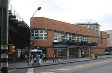
New York City Subway lines running through Bushwick include the BMT Jamaica Line (J and Z trains), the BMT Myrtle Avenue Line (M train), and the BMT Canarsie Line (L train).[97] The Myrtle–Wyckoff Avenues bus and subway hub was renovated into a state-of-the-art transportation center in 2007. New York City Bus lines serving Bushwick include the B13, B26, B38, B52, B54, B60.
During the 1960s, under the direction of Robert Moses, there were plans to build an extension of I-78 through Bushwick, to connect lower Manhattan with the southern shore of Long Island.[98] The extension was to be called the Bushwick Expressway, but was never built, due to then Mayor John V. Lindsay's concerns that traffic leaving Manhattan should bypass it via the Verrazano Bridge.[98]
Parks and recreation

All parks are operated by the New York City Department of Parks and Recreation.
- Bushwick Park and Pool is located on Flushing Avenue between Beaver and Garden Streets, and encompasses 1.29 acres (5,200 m2). The park has a free public pool as well as a children's pool, basketball courts, a handball court, and a children's playground.[99]
- Bushwick Playground is located on Knickerbocker Avenue between Woodbine Street and Putnam Avenue, and encompasses 2.78 acres (11,300 m2). The park features handball courts, spray showers, sitting areas, and a children's playground.[100]
- Green Central Knoll Park is a 2.6 acres (11,000 m2) park located between Flushing and Central Avenues and Knoll and Evergreen Streets. The park is located on the former site of the Rheingold beer brewery. New York City took ownership of the property after the beer company closed due to failure to pay taxes, but it was not given to the New York City Department of Parks and Recreation until 1997. The park includes a baseball field, sitting areas, and a children's playground.[101]
- Heisser Triangle is located at the intersections of Knickerbocker and Myrtle Avenues and Bleecker Street. The triangle is named after Charles Heisser, a World War I sergeant with the 106th Infantry who was killed in action in France on September 27, 1918. The bronze war memorial at the center of the plot was sculpted by Pietro Montana in 1921.[102]
- Hope Gardens Multi Service Center is a building located on Wilson Avenue and Linden Street that serves as an elderly bingo game building, an after-school program for children from kindergarten to fifth grade, a site for karate classes, and a summer day camp for local children.
- Irving Square Park is bound by Wilson and Knickerbocker Avenues and Halsey and Weirfield Streets. It encompasses 2.78 acres (11,300 m2) and is believed to be named after Washington Irving. The park features swings, a sandpit, a spray shower, a handball court, and a basketball court. Since being renovated in 2006 and 2008, the park also features a public plaza and gardening space.[103]
- Maria Hernandez Park is a municipal park; formerly known as Bushwick Park, it is located between Knickerbocker and Irving Avenues and between Starr and Suydam Streets, near the Jefferson Street station on the L train. It has a newly renovated basketball court, a handball court, fitness equipment, spray showers, benches, and a newly built performance stage.[104] The park encompasses 6.87 acres (27,800 m2).[105]
- Ridgewood Bushwick Youth Center is a youth activity center located between Gates Avenue and Palmetto Street and run by the Ridgewood Bushwick Senior Citizens Council (RBSCC).[106]
Education
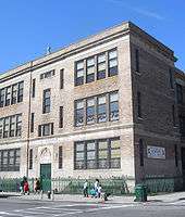
Bushwick has a robust educational infrastructure of thirty-three public and private, primary and secondary schools.[107] This includes 14 public elementary schools, one charter school, four parochial schools, seven high schools, and one secondary school.
High schools
- Academy for Environmental Leadership
- Brooklyn Latin School
- Bushwick Campus (formerly Bushwick High School) containing:
- Academy of Urban Planning
- Academy for Environmental Leadership
- The Brooklyn School for Math and Research
- Bushwick School for Social Justice
- Bushwick Community High School
- Bushwick Leaders' HS for Academic Excellence
- EBC for Public Service-Bushwick
- Grand Street Campus containing:
- High school for Legal Studies
- Progress High School
- High School of Enterprise, Business, & Technology
- MESA Charter High School
Combined middle and high schools
- All City Leadership Secondary School
- Achievement First University Prep High School
Notable people
- 6ix9ine (born 1996), rapper who received international attention for his 2017 breakout hit song "Gummo".[108][109]
- Jules de Balincourt (born 1972), contemporary artist[110]
- Andre Charles (born 1968), graffiti artist[111]
- D-Stroy, rapper
- Da Beatminerz, hip hop production team[112]
- Maritza Davila (born 1963), politician who represents the 53rd district in the New York State Assembly.[113]
- Ryan J. Davis (born 1982), theatre director and social media director at Blue State Digital[114]
- Jackie Gleason (1916–1987), actor[115]
- Rick Gonzalez (born 1979), actor[116]
- John Francis Hylan (1868–1936), former mayor of New York City[117]
- Elle King (born 1989), singer.[118]
- Timbo King (born 1973), rapper
- Eddie Murphy (born 1961), comedian and actor.[119][120]
- Mike Nieves, Deputy Chief of Staff to former City Council Speakers Christine Quinn, Gifford Miller, and Peter Vallone
- Harry Nilsson, (1941–1994), singer/songwriter[121]
- O.C. (born 1971), rapper
- Jeannie Ortega (born 1986), singer[122]
- Rosie Perez (born 1964), actor.[123]
- Q-Unique, rapper
- Anthony Ramos, (born 1991), actor and performer from Hamilton[124]
- Phil Rizzuto (1917–2007), baseball player and broadcaster[125]
- Mae West (1893–1980), actor.[126]
- Dwight York (born 1945), leader of the Nuwaubian Nation movement
Gallery
)
References
Notes
- 1 2 3 4 Table PL-P5 NTA: Total Population and Persons Per Acre - New York City Neighborhood Tabulation Areas*, 2010, Population Division - New York City Department of City Planning, February 2012. Accessed June 16, 2016.
- 1 2 "Demographics and profiles at the Neighborhood Tabulation Area (NTA) level". NYC Department of City Planning. 2012. Retrieved June 16, 2018.
- ↑ "Precincts | 83rd Precinct". nyc.gov. Retrieved May 8, 2011.
- 1 2 "NYC City Council". nyc.gov. Retrieved May 5, 2011.
- 1 2 "NYC Council". nyc.gov. Retrieved May 5, 2011.
- ↑ "Brooklyn College of the City University of New York, Department of Sociology, Sociology of Brooklyn Page". brooklyn.cuny.edu. Retrieved May 5, 2011.
- ↑ "Postal Zip Code Map for Brooklyn, New York". brooklyn.com. Archived from the original on March 17, 2011. Retrieved May 5, 2011.
- ↑ "Grimy, Industrial Bushwick Is a New Hotbed of Galleries". Art America. Retrieved 14 January 2013.
- ↑ VITULLO-MARTIN, Julia. "Bushwick Buzzing, but Not Quite Ready for Prime Time". New York Sun. Retrieved 14 January 2013.
- 1 2 DOCUMENTARY STUDY: 55 GOODWIN PLACE HOUSING SITE, Borough of Brooklyn, for New York city Department of Housing Preservation and Development. Revised October 1989.
- ↑ Bedford Stuyvesant/Expanded Stuyvesant Heights Historic District: Designation Report
- ↑ Pollak, Michael. "F.Y.I.", The New York Times, February 27, 2005. Accessed February 2, 2017. "Q. Where is the geographic center of New York?... According to the Department of City Planning, the population center lies in Maspeth, Queens, near the intersection of Galasso Place and 48th Street, near Maspeth Creek. The geographic center is in Bushwick, Brooklyn, on Stockholm Street between Wyckoff Avenue and St. Nicholas Avenue."
- ↑ Staff. "CITY'S HUB PLACED IN BUSHWICK YARD; Regional Plan Group Finds Geographic Center Is Far From Population Center", The New York Times, March 26, 1937. Accessed February 2, 2017. "The Regional Plan Association, whose offices at 400 Madison Avenue are now found to lie on the northwesterly outskirts of the city, announced yesterday that its engineers have discovered, for the first time, that a certain back yard in the Bushwick area of Brooklyn is the geographical center of New York City.... The association found, in effect, that anyone desiring to be centrally located in New York City in the literal geographic sense must live in that block of brownstone houses bounded by Reid and Stuyvesant Avenues, Van Buren Street and Greene Avenue in Brooklyn."
- ↑ Archived January 3, 2009, at the Wayback Machine.
- 1 2 "State of the City's Housing & Neighborhoods 2008: Bushwick" (PDF). Furman Center for Real Estate & Urban Policy. 2008. Retrieved 2009-07-01.
- 1 2 Table PL-P3A NTA: Total Population by Mutually Exclusive Race and Hispanic Origin - New York City Neighborhood Tabulation Areas*, 2010, Population Division - New York City Department of City Planning, March 29, 2011. Accessed June 14, 2016.
- ↑ "Sunday afternoon in New York City: from the Puerto Rican parade to the Egg Creams and Egg Rolls Jewish-Chinese festival". New Women New Yorkers. 2014-06-22. Retrieved 2016-05-15.
- ↑ "THE STORY OF U.S. PUERTO RICANS - PART FOUR | Centro de Estudios Puertorriqueños". centropr.hunter.cuny.edu. Archived from the original on May 18, 2016. Retrieved May 15, 2016.
- ↑ "Deeper look at Domino history". The Brooklyn Paper. Retrieved 2016-05-15.
- 1 2 "Bio". Brooklyn Borough Hall - Official Site. 2014-07-24. Retrieved 2016-05-27.
- ↑ "Congresswoman Nydia M. Velázquez -- New York's 7th Congressional District". velazquez.house.gov. Archived from the original on May 15, 2016. Retrieved May 15, 2016.
- ↑ "Brooklyn's Puerto Rican Day Parade kicks off Sunday". NY Daily News. Retrieved 2016-05-15.
- ↑ "Bienvenidos a la Nueva Isla Cuchifritos en Bushwick!". Bushwick Daily. 2016-03-18. Retrieved 2016-05-27.
- ↑ "La Isla - Bushwick - Brooklyn, NY". Yelp. Retrieved 2016-05-15.
- ↑ "Bushwick photos". am New York. Retrieved 2016-05-15.
- ↑ Iversen, Kristin (2013-02-27). "Is Williamsburg Trying to Deny Its Puerto Rican History?". Brooklyn Magazine. Retrieved 2016-05-15.
- ↑ "Make the Road New York | Participate". www.maketheroadny.org. Retrieved 2016-05-15.
- ↑ "Local Latino Activists Meet to Support Bernie on the Eve of Big Wisconsin Win". Bushwick Daily. 2016-04-06. Retrieved 2016-05-27.
- ↑ "Bernie Sanders for President | Event | Bushwick Latino Community Organizing Meet-Up". go.berniesanders.com. Retrieved 2016-05-27.
- ↑ "Kikiriki Live Poultry - Bushwick - Brooklyn, NY". Yelp. Retrieved 2016-05-16.
- ↑ "Bushwick Candidates Focused on Housing: Who is Who". Bushwick Daily. 2013-08-29. Retrieved 2016-05-27.
- ↑ "NY Senate District 18". NY State Senate. Retrieved 2016-05-27.
- ↑ "Bushwick Houses". www.nyc.gov. Archived from the original on April 21, 2016. Retrieved May 16, 2016.
- ↑ "Hope Gardens Houses". www.nyc.gov. Archived from the original on March 31, 2016. Retrieved May 16, 2016.
- ↑
- 1 2 Kenneth T. Jackson: The Encyclopedia of New York City: The New York Historical Society; Yale University Press; 1995. p.171.
- ↑ Block, Stock & Barrel Archived May 20, 2012, at the Wayback Machine.. Block Magazine.
- ↑ History of Bushwick Archived September 27, 2008, at the Wayback Machine.. Retrieved November 19, 2006
- ↑ The Rise of Slavery: New York had the most slaves in the North, and Long Island had almost half of them, Newsday. Retrieved November 19, 2006
- ↑ A Black History of Jamaica, New York. Retrieved November 19, 2006
- ↑ "Archived copy". Archived from the original on January 14, 2009. Retrieved March 7, 2008.
- 1 2 Williams, Keith. "Bushwick, Suydam House, and the mark of the Hessians". The Weekly Nabe. Retrieved 3 October 2012.
- ↑ Field, T.W. (1868). Historic and antiquarian scenes in Brooklyn and its vicinity: with illustrations of some of its antiquities.
- ↑ Armbruster, Eugene (1912). The Eastern district of Brooklyn. G. Quattlander.
- ↑ Greenpoint History. Retrieved November 19, 2006
- ↑ HISTORY OF BROOKLYN: CHAPTER IX. BUSHWICK AND WILLIAMSBURGH, FROM THE CLOSE OF THE REVOLUTION, UNTIL 1854. Retrieved November 19, 2006
- ↑ RootsWeb: NYBROOKLYN-L Archives. Archiver.rootsweb.com.
- ↑ RootsWeb: NYKINGS-L Archives. Archiver.rootsweb.com.
- ↑ Obsolete Brooklyn Street Names. Brooklyn.net (November 15, 2003).
- ↑ "Archived copy". Archived from the original on February 9, 2007. Retrieved February 12, 2007.
- ↑ "Archived copy". Archived from the original on January 14, 2009. Retrieved March 7, 2008.
- ↑ F. J. Berlenbach House Designation Report. (PDF).
- ↑ STILES VOL 3. Panix.com.
- ↑ http://www.myinsulators.com/glassfactories/brookfield.html. Retrieved March 7, 2008. Missing or empty
|title=(help) - ↑ Walking Tours: Bushwick. Retrieved December 24, 2006
- ↑ The Bushwick Pilsners: A Look at Hoppier Days by Ben Jankowski Republished from BrewingTechniques' January/February 1994. http://brewingtechniques.com/library/backissues/issue2.1/jankowski.html
- ↑ NYBROOKLYNL Archives: March 2000. Retrieved December 24, 2006
- ↑ New York Food Museum: Beer. Retrieved December 24, 2006
- ↑ http://www.industrialnewyork.com/rail/2003515bushwick/index.shtml%5Bpermanent+dead+link%5D
- ↑ Early Rapid Transit in Brooklyn, 1878-1913. http://www.nycsubway.org.
- ↑ Dr. Cook's Mansion and Other Bushwick Mansions. Retrieved December 24, 2006
- ↑ The Bushwick Renaissance Initiative Archived February 6, 2009, at the Wayback Machine.. Retrieved December 24, 2006
- ↑ http://www.nyc.gov/html/hpd/html/about/bushwickwalkingtour.shtml. Retrieved March 7, 2008. Missing or empty
|title=(help) - 1 2 Archived August 24, 2007, at the Wayback Machine.
- ↑ "The Death and Life of Bushwick". City Journal. (July 13, 1977).
- ↑ Gottlieb, Martin. (February 2, 1986) "F.H.A. CASE RECALLS BUSHWICK IN 70'S". The New York Times.
- ↑ Archived February 6, 2009, at the Wayback Machine.
- ↑ NEIGHBORHOOD REPORT: "BUSHWICK UPDATE; Rough Sailing in Wake of Drug Crackdown". The New York Times (November 21, 1993).
- ↑ 83rd Precinct CompStat Report Archived February 28, 2008, at the Wayback Machine.. (PDF).
- 1 2 3 4 5 6 Bushwick Initiative Draft.indd. (PDF).
- ↑ Sullivan, Robert. "Psst... Have You Heard About Bushwick?" The New York Times, 5 Mar 2006. Retrieved May 3, 2008 .
- ↑ Cotter, Holland (June 7, 2012). "Bushwick Open Studios". The New York Times.
- ↑ "Artists' Trailer Park Is History". City Room. Retrieved 2016-01-03.
- ↑ "Brooklyn Artist Collective Left Homeless". Heeb. Retrieved 2016-01-03.
- ↑ "'Entrepreneur' Links Immigrants to Radio Stations Back HomeVoices of NY". voicesofny.org. Retrieved 2016-01-03.
- ↑ "Bushwick Trailer Park Welcomes Artists -- AOL Real Estate". AOL Real Estate Blog. Retrieved 2016-01-03.
- ↑ "Congresswoman Nydia M. Velasquez". house.gov. Archived from the original on May 5, 2011. Retrieved May 8, 2011.
- ↑ "New York State Senator Martin Malavé Dilan". nysenate.gov. Retrieved May 8, 2011.
- ↑ "NYS Assembly Member Vito J. Lopez". assembly.state.ny.us. Retrieved May 8, 2011.
- ↑ "Assembly District 54". assembly.state.ny.us. Retrieved May 8, 2011.
- ↑ "New York State Assembly | Latrice Walker". assembly.state.ny.us. Retrieved 2017-07-27.
- ↑ "NYS Assembly Member Annette Robinson". assembly.state.ny.us/. Retrieved May 8, 2011.
- ↑ "83rd Precinct". NYPD. Retrieved June 20, 2018.
- ↑ "NYC Fire Department". nyc.gov. Retrieved May 8, 2011.
- ↑ "Wyckoff Heights Medical Center". wyckoffhospital.org. Retrieved May 8, 2011.
- ↑ "Woodhull Medical Center". nyc.gov. Retrieved May 8, 2011.
- ↑ "DeKalb Library". Brooklyn Public Library. Retrieved June 20, 2018.
- ↑ "Bushwick Library". Brooklyn Public Library. Retrieved June 20, 2018.
- ↑ "Washington Irving Library". Brooklyn Library. Retrieved June 20, 2018.
- ↑ "USPS Locations". Retrieved June 20, 2018.
- ↑ "USPS Locations". Retrieved June 20, 2018.
- ↑ NYCHA locations in Bushwick Archived May 25, 2015, at the Wayback Machine.. Nyc.gov.
- ↑ "Bushwick II CDA (Group E)" (PDF). Retrieved 2018-06-20.
- ↑ Gottlieb, Martin (August 15, 1993). "Bushwick's Hope Is a Public Project". The New York Times.
- ↑ "Hope Gardens" (PDF). Retrieved 2018-06-20.
- ↑ "Palmetto Gardens" (PDF). Retrieved 2018-06-20.
- ↑ "Subway Map" (PDF). Metropolitan Transportation Authority. January 18, 2018. Retrieved January 18, 2018.
- 1 2 "Bushwick Expressway (I-78, unbuilt)". nycroads.com. Retrieved May 8, 2011.
- ↑ "Bushwick Playground". nycgovparks.org. Retrieved May 8, 2011.
- ↑ "Bushwick Playground II". nycgovparks.org. Retrieved May 8, 2011.
- ↑ "Green Central Knoll". nycgovparks.org. Retrieved May 8, 2011.
- ↑ "Heisser Triangle". nycgovparks.org. Retrieved May 8, 2011.
- ↑ "Irving Square Park". nycgovparks.org. Retrieved May 8, 2011.
- ↑ Maria Hernandez Park Highlights : NYC Parks
- ↑ "Maria Hernandez Park". nycgovparks.org. Retrieved May 8, 2011.
- ↑ "Ridgewood/Bushwick Youth Center". ycgovparks.org. Archived from the original on April 26, 2010. Retrieved May 8, 2011.
- ↑ NYC Department of City Planning CB4 Profile Archived June 2, 2010, at the Wayback Machine.. None.
- ↑ Mench, Chris. "Here’s What You Need To Know About Controversial Brooklyn Rapper 6ix9ine & His Breakout Hit 'Gummo'", Genius (website), November 15, 2017. Accessed January 22, 2018. "Bushwick, Brooklyn rapper 6ix9ine (a.k.a. Teka$hi 6ix9ine) is one of the most controversial artists out right now, but that hasn't stopped the rise of his breakout hit 'Gummo.'"
- ↑ Emmanuel C.M. "6ix9ine’s “Gummo” Streaming Numbers Soar Amid Controversy", XXL (magazine), November 21, 2017. Accessed February 12, 2018. "Daniel Hernandez, better known by his stage name 6ix9ine, is a Brooklyn-born rapper who currently has one of the hottest songs on the internet. 6ix9ine's 'Gummo' has amassed over 28 million YouTube views since its release in October and has collected over 3 million streams on Spotify. From his rainbow-colored hair and matching grills, to the numerous No. 69 tattoos all over his body, the young Bushwick, Brooklyn rapper, who also goes by Teka$hi 6ix9ine, has a unique outer presence. He's been popping up more and more on the web over the last two months, however, controversy surrounds him."
- ↑ Newton, Matthew. "Life After Graduation", Art:21, April 21, 2010. Accessed October 9, 2016. "Jules de Balincourt in his Bushwick studio following his solo exhibition opening at Deitch Projects in SoHo"
- ↑ "Archived copy". Archived from the original on May 9, 2009. Retrieved September 27, 2009.
- ↑ Mlynar, Phillip. "Bushwick’s Finest: Forgotten Heroes of the Brooklyn Hip Hop Underground", Red Bull Music Academy, April 25, 2014. Accessed October 9, 2016. "Despite the lack of a breakthrough Bushwick star though, the area has left behind a fascinating seam of mid-'90s underground hip hop, sparked by Da Beatminerz and defined by a quartet of now-cult artists."
- ↑ Maritza Davila Biography, New York State Assembly. Accessed February 14, 2018. "Maritza Davila was born in Catano, Puerto Rico and moved to Bushwick, Brooklyn as a young girl, where she has lived ever since."
- ↑ Blog. Ryanjdavis.blogspot.com.
- ↑ Staff. "Kid's Talk", News & Record (Greensboro), September 19, 1995. Accessed June 8, 2009.
- ↑ Ramos, Steve. "'Illegal Tender Star Rick Gonzalez Is a Mama's Boy", Vulture.com, August 23, 2007. Accessed October 9, 2016. "Taking homeboy Rick Gonzalez out of Bushwick means bright lights and enthusiastic crowds outside the Chelsea West Cinemas for the Monday-night premiere of Illegal Tender, a Latino mob movie in which Gonzalez plays a straight-arrow college kid unaware of his family's drug-dealing past."
- ↑ Staff. "CITY'S HUB PLACED IN BUSHWICK YARD; Regional Plan Group Finds Geographic Center Is Far From Population Center", The New York Times, March 26, 1937. Retrieved June 9, 2009. "Its best known resident in recent years was former Mayor John F. Hylan, who lived on Bushwick Avenue."
- ↑ "Elle King", Hollywoodlife.com. Accessed May 17, 2016. "She currently resides in Bushwick, Brooklyn."
- ↑ Lovece, Frank. "'Beverly Hills Cop 3 - Eddie Murphy Is Back", Calhoun Times, June 1, 1994. Accessed February 12, 2018. "Murphy's used to taking knocks. Raised in the projects, in the Bushwick section of Brooklyn, he saw his parents divorce when he was 3."
- ↑ Eddie Murphy Biography - Facts, Birthday, Life Story. Biography.com (April 3, 1961).
- ↑ Jackson, Kenneth T. The Scribner Encyclopedia of American Lives, Volume 4, Gale (publisher), 2000. ISBN 9780684806440. Accessed July 31, 2016. "Nilsson spent most of his early childhood living in an apartment at 762 Jefferson Avenue in the Bushwick section of Brooklyn with his mother and half sister, his maternal grandparents, two uncles, an aunt, and a cousin."
- ↑ Jeannie Ortega: Biography, Billboard (magazine). Accessed July 31, 2016. "Born Jeannette Ortega in the tough Bushwick section of Brooklyn on November 19, 1986, Ortega devoted herself to a career in show business at an early age, busking as part of an adolescent song and dance duo called Sugar and Spice by the turn of the millennium."
- ↑ Brown, Ruth. "Do the write thing: Rosie Perez reveals traumatic childhood in new memoir", The Brooklyn Paper, February 21, 2014. Accessed May 17, 2016. "In her candid new memoir, Handbook for an Unpredictable Life, the Brooklyn-born and bred actress reveals her traumatic childhood in Bushwick and upstate New York, chronicling the poverty, racism, sexism, and abuse she overcame on the rocky road to stardom."
- ↑ Stewart, Zachary. "Anthony Ramos Went From Baseball in Bushwick to Performing Hamilton for Barack Obama; One of the stars of Broadway's next big hit on the series of lucky shots that led him to this place.", Theater Mania, August 5, 2015. Accessed July 31, 2016. "When Anthony Ramos was growing up in the Bushwick neighborhood of Brooklyn he never imagined he'd be starring in a Broadway show, much less the most sensational musical to hit the Rialto in years."
- ↑ New York Magazine Dec 24, 1984. New York Magazine. Retrieved May 8, 2011.
- ↑ Thompson, Howard. "Mae West, 76, Still Finding New Generations of Fans", The New York Times, June 25, 1970. Accessed May 17, 2016. "'Tomorrow I'm going out to Bushwick - we lived next door to Mayor [John] Hylan -- to see what's left of the old place.'"
Bibliography
- Goodman, James, Blackout. North Point Press. New York, NY 2003 ISBN 0-86547-658-6
- Jackson, Kenneth T. and John B. Manbeck, The Neighborhoods of Brooklyn, 2nd ed. New Haven: Yale University Press, 2004, 4448. ISBN 0-300-10310-7
- Robert Sullivan (March 5, 2006). "Psst... Have You Heard About Bushwick?". The New York Times. Retrieved August 8, 2006.
- Christine Lagorio (December 7, 2005). "CloseUp on Bushwick, Brooklyn". Retrieved August 8, 2006.
- Jeff Vandam (June 11, 2006). "BargainHunting? Stay on the LTrain a Little Longer". The New York Times. Retrieved August 11, 2006.
- Cooper, Mabusha "Push ", PUSH HIP HOP HISTORY- The Brooklyn Scene, 1st Books Library, ISBN 1-4107-9935-2
External links
| Wikimedia Commons has media related to Bushwick, Brooklyn. |
Places adjacent to Bushwick, Brooklyn | |
|---|---|
Coordinates: 40°41′39″N 73°55′07″W / 40.69417°N 73.91861°W