Community boards of Manhattan
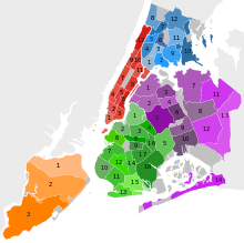
Community boards of Manhattan are New York City community boards in the borough of Manhattan, which are the appointed advisory groups of the community districts that advise on land use and zoning, participate in the city budget process, and address service delivery in their district.[1]
Community boards are each composed of up to 50 volunteer members appointed by the local borough president, half from nominations by City Council members representing the community district (i.e., whose council districts cover part of the community district).[2][3] Additionally, all City Council members representing the community district are non-voting, ex officio board members.[3]
Community District 1
Consists of neighborhoods:[4]
- TriBeCa
- Financial District, Manhattan
- Civic Center - older name was Five Points
- Battery Park City
- South Street Seaport
- Battery Park
- City Hall Park
- Besides, there are three virtually uninhabited islands in the District. Their status is complicated by a number of political and historical factors:
Community District 2
Consists of neighborhoods:[5]
- Greenwich Village
Greenwich Village includes also: - NoHo
- SoHo
- SoHo, to its west, includes Hudson Square
- Little Italy
Community District 3
Consists of neighborhoods:[6]
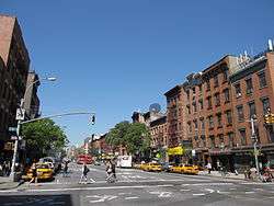
- Lower East Side
- East Village
- Tompkins Square Park is located in East Village
- Avenues A to D are sometimes known as Alphabet City
- Chinatown
- Two Bridges
Community District 4
Consists of neighborhoods:[7]
- Hell's Kitchen (also called Clinton)
- Chelsea
Sources:
Community District 5
Consists of neighborhoods:[8]
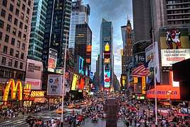
- Midtown
- Times Square
- Herald Square
- Midtown South
- part of Murray Hill [9]
- part of Gramercy[10]
- Union Square
Community District 6
Consists of neighborhoods:[11]
- part of Murray Hill[12]
- Sutton Place
- Beekman Place
- Turtle Bay
- Tudor City
- part of Gramercy[13]
- Kips Bay area is located inside Gramercy
- Peter Cooper
- Stuyvesant Park
- Stuyvesant Town
Bellevue Hospital Center and the United Nations headquarters are located in the District.
Community District 7
Consists of one neighborhood:
- Upper West Side including:[14]
- Central Park West Historic District
- Northern part of Upper West Side between West 96 Street and West 110 Street is known as Manhattan Valley or West Harlem
- Lincoln Square including Lincoln Center
Community District 8
Consists of neighborhoods:[15]
- Yorkville
- Carl Schurz Park is located in Yorkville
- Upper East Side
- Lenox Hill
The following neighborhoods are located on the same named islands in East River.
North-Western area of the District with South-Eastern boundary point at 3rd Avenue and East 86 Street is named Carnegie Hill
Community District 9
Consists of neighborhoods:[16]
Community District 10
Consists of the only neighborhood:[17]
Polo Grounds is located in the District.
Community District 11
Consists of only one neighborhood on Manhattan Island:[18]
Sometimes it is named Spanish Harlem or El Barrio Besides two neighborhoods, located on the same named islands are parts of the District:
There is Mount Morris Park in the District.
Community District 12
Consists of two neighborhoods:[19]
- Inwood
- Washington Heights
- Part of Washington Heights is known as Hudson Heights
Inwood Hill Park is located in the District.
Other areas
Marble Hill, while legally a part of New York County ("Manhattan") is represented by Bronx Community Board 8.
Within the borough of Manhattan there is one Joint Interest Area (JIA), which is outside of the jurisdiction of individual community districts, and have their own district number.[20][21] The JIA in New York county is:
- District 64 - Central Park, 2010 Census population: 25
See also
References
- ↑ Berg, Bruce (2007). New York City Politics: Governing Gotham. Rutgers University Press. p. 277.
- ↑ "About Community Boards". NYC Mayor's Community Affairs Unit. Retrieved 26 November 2016.
- 1 2 New York City Charter § 2800(a)
- ↑ NYC DCP Profile of Community District 1
- ↑ NYC DCP Profile of Community District 2
- ↑ NYC DCP Profile of Community District 3
- ↑ NYC DCP Profile of Community District 4
- ↑ NYC DCP Profile of Community District 5
- ↑ West of Lexington Avenue (west of Madison Avenue between East 40th Street and East 34th Street)
- ↑ West of Lexington Avenue
- ↑ NYC DCP Profile of Community District 6
- ↑ East of Lexington Avenue (East of Madison Avenue between East 40th Street and East 34th Street)
- ↑ East of Lexington Avenue
- ↑ NYC DCP Profile of Community District 7
- ↑ NYC DCP Profile of Community District 8
- ↑ NYC DCP Profile of Community District 9
- ↑ NYC DCP Profile of Community District 10
- ↑ NYC DCP Profile of Community District 11
- ↑ NYC DCP Profile of Community District 12
- ↑ NYC Department of City Planning. "Joint Interest Areas and Sources & Disclaimer". www1.nyc.gov. Retrieved 21 March 2018.
- ↑ "2010 Census Table G-1: 2010 Community District Geography Notes" (PDF). Retrieved 11 April 2018.
External links
| Lower Manhattan below 14th St (CB 1, 2, 3) |
|   |
|---|---|---|
| Midtown (CB 5) | ||
| West Side (CB 4, 7) | ||
| East Side (CB 6, 8) | ||
| Upper Manhattan above 110th St (CB 9, 10, 11, 12) | ||
| Islands |
| |
| Former | ||