Sunset Park, Brooklyn
| Sunset Park, Brooklyn | |
|---|---|
| Neighborhood of Brooklyn | |
 | |
|
Location in New York City | |
| Coordinates: 40°38′46″N 74°00′43″W / 40.646°N 74.012°WCoordinates: 40°38′46″N 74°00′43″W / 40.646°N 74.012°W | |
| Country |
|
| State |
|
| City | New York City |
| Borough | Brooklyn |
| Government | |
| • Council Member | Carlos Menchaca |
| Population (2010)[1] | |
| • Total | 126,000 |
| ZIP code | 11220, 11232, 11219 |
| Area code(s) | 718, 347, 929, and 917 |
|
Sunset Park Historic District | |
  | |
| Location | Roughly bounded by the Upper New York Bay, Thirty-sixth St., Ninth Ave. and Sixty-fifth St., Brooklyn, New York |
| Area | 280 acres (110 ha) |
| Architect | Pohlman & Patrick; Et al. |
| Architectural style | Renaissance Revival, Romanesque Revival, Neo-Grec; Classical Revival |
| NRHP reference # | 88001464[2] |
| Added to NRHP | September 15, 1988 |
Sunset Park is a neighborhood in the southwestern part of the New York City borough of Brooklyn, bounded by Park Slope and Green-Wood Cemetery to the north, Borough Park to the east, Bay Ridge to the south, and Upper New York Bay to the west.[3][4][5]
The neighborhood is named after a 24.5-acre (9.9 ha) public park founded in the 1890s,[6][7] between 41st and 44th Streets and 5th and 7th Avenues. The park's elevated location offers views of New York Harbor; Manhattan; the Statue of Liberty; and, more distantly, the hills of Staten Island and the U.S. state of New Jersey.[8][9]
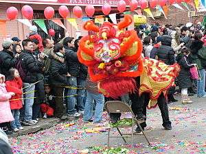
Sunset Park's population is composed of Puerto Ricans, Mexicans and other Hispanics, in addition to Chinese, Indians and Norwegians. The core of the Hispanic population is west of 5th Avenue, while the Chinese population straddles the area from 7th Avenue eastward to Borough Park, one of Brooklyn's fastest-growing Chinatowns.[10] The ethnic diversity of the neighborhood is celebrated annually with the Sunset Park Parade of Flags down 5th Avenue.
The neighborhood is part of Community Board 7, and served by the New York City Police Department's 72nd Precinct.[11] Fire services are provided by Engine Company 201, Engine Company 228 and Ladder Company 114.[6] The Brooklyn Public Library has a branch located on 4th Avenue at 51st Street.[6] The area is also home to the Jackie Gleason Bus Depot, named in honor of the Brooklyn-born actor.
History

The area which is now Sunset Park was purchased from the Canarsee Indians by Dutch settlers in the 1640s. Their first farms were laid out along the waterfront. The area was still primarily agriculture in the 1830s, at which time streets were laid out and development began, and remained that way until the middle of the 19th century. A ferry pier and railroad terminal, popular as a transfer point for those traveling to Coney Island, was built in the 1870s.[6][5]
In the heyday of the New York Harbor's dominance of North American shipping during the 19th century, Sunset Park grew rapidly, largely as a result of Irish, Polish, Finnish, and Norwegian immigrant families moving to the area. Portions of the neighborhood became known as "Finn Town"[12][13] and "Little Norway".[6] The Finns brought with them the concept of cooperative housing,[6] and the apartment house at 816 43rd Street is said to be the first cooperative apartment building in New York City.[9] The Irish subjected the other groups, especially the non-Catholic Finns and Norwegians to harassment and abuse, which resulted in some of the latter leaving the area.
The area's residential construction took place primarily in the late 19th and early 20th century, and included "limestones and brownstones, as well and brick and wood rowhouses".[6] The neighborhood grew up around the Bush Terminal of Irving T. Bush, a model industrial park between 39th and 53rd Streets completed in 1895 – and called "Bush's Folly" at the time, as people had a hard time believing it could compete with the port of Manhattan[6] – and continued to grow through World War II, when the Brooklyn Army Terminal between 53rd and 66th Streets employed more than 10,000 civilians to ship 80% of all American supplies and troops.[14]
The neighborhood began to decline in the 1930s and 1940s,[6] with the depredations of the Great Depression. The construction of the elevated Gowanus Parkway, which replaced the BMT Third Avenue Elevated in 1941, effectively cut the neighborhood off from the harbor. Sunset Park's shipping sector declined after World War II, with the rise of truck-based freight shipping and ports in New Jersey; the growth of the closure of the Army Terminal; and the decreasing importance of heavy industry in the northeastern United States. In 1945 Third Avenue was widened to ten lanes at the surface level to accommodate the truck traffic to/from the Brooklyn–Battery Tunnel. This widening necessitated the removal of all industrial buildings and housing on the east side of the avenue. The four-lane parkway was replaced in the 1960s with a similarly named six-lane expressway to carry truck and car traffic to and from the then-new Verrazano-Narrows Bridge, which opened in 1964.
As these economic and infrastructural changes occurred, the neighborhood's population began to change as well. White flight to the suburbs began to take its toll. Families who had lived in the community for decades began moving out, and their homes – largely modest but attractive rowhouses – lost value. Due to corruption in the banking and real-estate industries, and in the Federal Housing Administration, many housing units were lost to abandonment.[6]
With aid from federal, state, and local agencies, Sunset Park slowly began its rebirth, helped by the purchase by new investors of Bush Terminal in 1965 and its conversion into an industrial park, the expansion of St. Lutheran Medical Center in 1969, the 1987 re-opening of the Brooklyn Army Terminal, and new immigration into the area. By the 1980s and 1990s, the neighborhood was being reborn.[6][5]
Sunset Park was hit by the tornadoes of August 8, 2007. Significant damage was reported to homes on 58th Street between 7th and 5th Avenues and 67th to 66th Streets between 5th and 6th Avenues.[15]
In February 2016, Sunset Park West was one of four neighborhoods featured in an article in The New York Times about "New York’s Next Hot Neighborhoods". Factors cited in the article included redevelopment along the waterfront, a new training facility for the Brooklyn Nets professional basketball team, the opening of Bush Terminal Park between 44th and 51st Streets in 2014, plans to improve Industry City – the former Bush Terminal, and the use of warehouses as party and event spaces. According to real-estate sources cites, all of these business- and office-related activities will "drive residential momentum" in the western part of Sunset Park.[16] Some in the neighborhood have expressed fears of the "gentrification" that could follow in the wake of these developments.[17]
Demographics
The 2000 United States Census[1] for the zip code 11220, which encompasses most of Sunset Park, Brooklyn, approximates that there were 120,441 people living in the neighborhood; 50.5% were male and 49.5% female. The median age was 30.8; 17.8% of residents were children, 73.2% were adults (18 years and over), and 9% were senior citizens (65 or over).
There were 29,723 total housing units, of which 95.8% were occupied, and 75.1% were rented and 24.9% were owned; The median property value was $235,400. The median household income in 1999 U.S. dollars was $30,152, and the median family income was $31,247. The per capita income was $13,141; 27.9% of individuals and 26% of families were living below the poverty line. 93.9% of residents were of one race, while 6.1% were multiracial; Roughly 42.6% of residents were Hispanic or Latino, 36.2% were white, 29% were Asian (mostly Chinese), 3.2% were black/African American, and 24.7% were another race/ethnicity.
Until the early 1960s, Sunset Park's main population was made up of immigrant Irish, Italians, Germans, and Nordic Americans. These groups began leaving the neighborhood during the 1970s and 1980s, and they were replaced by new immigrants. Many migrants came from Puerto Rico, immigrants from the Dominican Republic, and Meso-America, as well as other Latin American and Caribbean countries. By 1990, Hispanics constituted 50% of Sunset Park's population, and were rehabilitating property values and developing a thriving community, with an abundance of Hispanic restaurants and businesses along 5th Avenue. People from Gujarat in India have also been settling in and around Sunset Park since 1974; they are mostly Christian and attend three of the area's churches, at 45th Street and 8th Avenue, at 56th Street and 4th Avenue, and at 52nd Street and 8th Avenue.[18] These churches have a mainly Indian congregation and festive parties in the church halls.
In the 1980s, Sunset Park became the location of the borough's first Chinatown, which is located along 8th Avenue from 42nd to 68th Street and has rapidly attracted many Chinese immigrants. Eighth Avenue is lined with Chinese businesses, including grocery stores, restaurants, Buddhist temples, video stores, bakeries, community organizations, and a Hong Kong Supermarket.


Like the Manhattan Chinatown (of which the Brooklyn Chinatown is an extension[19]), Brooklyn's Chinatown was originally settled by Cantonese immigrants. In recent years, however, to the discontent of many of the Cantonese, an influx of Fuzhou immigrants has been supplanting the Cantonese at a significantly faster rate than in Manhattan's Chinatown; in recent years, this trend has slowed down, with fewer Fuzhouese coming to Sunset Park each year.[20] By 2009 many Mandarin-speaking originators had moved to Sunset Park.[21]
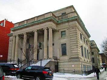
Architecture and landmarks
A portion of the neighborhood is listed on the National Register of Historic Places as a historic district, known for its Romanesque and Renaissance Revival architecture. It is the largest historic district on the NRHP in the Northeast United States.[6] The neighborhood also has several individual landmarks designated by the New York City Landmarks Preservation Commission, including St. Michael's Church, the Harde & Short-designed Dr. Maurice T. Lewis House (one of the firm's few non-Manhattan projects and the neighborhood's only freestanding mansion), the Sunset Park Courthouse, the Former 18th Police Precinct Station House and Stable, and the Sunset Play Center, a rare exterior and interior landmark.[22] As the designation report for the Play Center states, "The Sunset Play Center is one of a group of eleven immense outdoor swimming pools opened in the summer of 1936 in a series of grand ceremonies presided over by Mayor Fiorello LaGuardia and Parks Commissioner Robert Moses. All of the pools were constructed largely with funding provided by the Works Progress Administration (WPA)."[23]
The Brooklyn Army Terminal is west of 1st Avenue. 1st and 2nd Avenues are surrounded by factories, cargo storage and other industrial buildings. 3rd and 4th Avenues contain residential dwellings (primarily apartment buildings) alongside commercial and industrial elements. 5th Avenue is a middle class commercial thoroughfare with tenement housing. Primarily composed of brownstones, limestones, brick rowhouses and apartment buildings, residential 6th Avenue is the approximate border between the Hispanic area and Brooklyn's Chinatown. 7th and 8th Avenues are the two major hubs of Brooklyn's Chinatown. 9th Avenue (the border with Borough Park) has been mostly a quiet residential street. The cross streets are mostly industrial between 1st and 3rd Avenues but are mostly residential east of 3rd Avenue.
Dominated by three-story bayed rowhouses that were initially envisaged as "inexpensive imitations of the stately four- and five-story townhouses [...] of Brooklyn Heights, Carroll Gardens, Fort Greene and Park Slope", the neighborhood's "brownstone belt" (including homes with brownstone, sandstone, limestone, iron and ornamental brick facades) was developed between 1885 and 1910. Although many houses have shed internal architectural elements of the era, it continues to encompass a substantial swath of the residential stock between 4th and 6th Avenues south of 40th Street. However, brownstone rows exist as far north as 420-424 36th Street and as far east as 662 56th Street, while several two- and three-story bayed brick rows (notably exemplified by 240-260 45th Street) are situated south of 4th Avenue, where vinyl-sided frame and brick houses are historically prevalent.[24]
Gallery

 4th Avenue at 60th Street
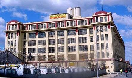 A factory at 2nd Avenue and 43rd Street
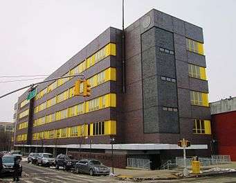 Sunset Park High School
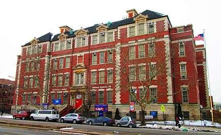 Charles O. Dewey and Sunset Park Prep middle schools share this building on 4th Avenue
 P.S. 24
 St. Michael's School, formerly a parochial school, now P.S. 516
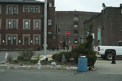 entrance to Bush Terminal Park at 43 Street and 2nd Avenue, Sunset Park, Brooklyn, New York
Transportation
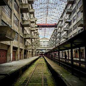
.jpg)
Sunset Park is served by road and rail services. The neighborhood has access to three limited-access highways; the I-278 (Gowanus) and NY 27 (Prospect) Expressways as well as the Belt Parkway.
Six New York City Bus bus lines serve Sunset Park: B9, B11, B35, B37, B63 and B70.
Several subway routes run through Sunset Park. The BMT Fourth Avenue Line (D, N, and R trains) has stations at 36th Street, 45th Street, 53rd Street and 59th Street. The BMT West End Line (D train) has a station at Ninth Avenue. The BMT Sea Beach Line (N train) has one station in Sunset Park at Eighth Avenue.
For some time, SeaStreak service was available at the Brooklyn Army Terminal to Pier 11/Wall Street, the East 34th Street Ferry Landing, the Sandy Hook Bay Marina, or Riis Landing on summer Fridays. Ferry service was created in the aftermath of the September 11th attacks when the Gowanus Expressway and New York City Subway were at capacity. It was free from October 2001 until April 2003, when the Federal Emergency Management Agency announced that it could not subsidize the service anymore. Then, until 2011 it was operated by the Red Hook, Brooklyn-based New York Water Taxi company on its Rockaway/Sandy Hook route. The Water Taxi service from the Brooklyn Army Terminal was part of the crucial contingency plan during the 2005 New York City transit strike.
Sunset Park has been served by NYC Ferry's South Brooklyn and Rockaway routes[25][26] since 2017.[27][28]
Much of the traffic between the Brooklyn and Manhattan Chinatowns is handled by privately held minibuses known in Chinese as "VAN 仔" and in English as "Chinese vans".
See also
Enclaves:
References
Notes
- 1 2 "FactFinder"
- ↑ National Park Service (2010-07-09). "National Register Information System". National Register of Historic Places. National Park Service.
- ↑ "Brooklyn Community District 7 - New York City Department of City Planning". nyc.gov. Retrieved June 1, 2015.
- ↑ Because it was once close to the southern boundary of the City of Brooklyn, Sunset Park is considered to be part of South Brooklyn. However, until the 1960s, the northern part of Sunset Park was considered to be part of Gowanus, and the southern part was included in Bay Ridge. The neighborhood received its own name in that decade.
- 1 2 3 4 Snyder-Grenier, Ellen Marie "Sunset Park" in Jackson, Kenneth T., ed. (2010), The Encyclopedia of New York City (2nd ed.), New Haven: Yale University Press, ISBN 978-0-300-11465-2 , pp.11266-67
- 1 2 3 4 5 6 7 8 9 10 11 12 Jackson, Kenneth T.; Manbeck, John B., eds. (2004), The Neighborhoods of Brooklyn (2nd ed.), New Haven, Connecticut: Citizens for NYC and Yale University Press, ISBN 0-300-10310-7 , pp.200-205
- ↑ Kadinsky, Sergey "Sunset Park" Hidden Waters Blog January 16, 2016
- ↑ "Sunset Park" New York City Department of Parks and Recreation
- 1 2 Federal Writers' Project (1939), New York City Guide, New York: Random House, ISBN 0-403-02921-X (Reprinted by Scholarly Press, 1976; often referred to as WPA Guide to New York City), p.468
- ↑ Sarah Jacobs (October 16, 2017). "A little-known Brooklyn neighborhood was named one of the world's coolest places — here's what it's like". Business Insider. Retrieved November 4, 2017.
- ↑ 72nd Precinct, New York City Police Department.
- ↑ "Brooklyn, New York. October 1942. Finnish-Americans in Finn Town, 39th Street near 8th Avenue". loc.gov. Retrieved June 1, 2015.
- ↑ Palotie, Laura (November 2011). "Finntown's slice of the Big Apple". This is Finland. Retrieved June 1, 2015.
- ↑ "Scandinavian influence in Brooklyn" Forgotten New York
- ↑ David, Kirsten (August 9, 2007) "A sweaty horde crosses Brooklyn Bridge - into chaos" New York Daily News
- ↑ Higgins, Michelle (February 26, 2016) "New York’s Next Hot Neighborhoods" The New York Times
- ↑ Gonzalez, David (March 6, 2016) "In Sunset Park, a Call for 'Innovation' Leads to Fears of Gentrification" The New York Times
- ↑ "Sunset Park, Brooklyn". New York City Neighborhoods. NYC Department of Housing Preservation & Development. Retrieved March 13, 2013.
- ↑ Zhou, Min (2010). Chinatown: The Socioeconomic Potential of an Urban Enclave. Philadelphia: Temple University Press. Retrieved November 10, 2013.
- ↑ Kwong, Peter (September 16, 2009). "Answers About the Gentrification of Chinatown". The New York Times. Retrieved October 1, 2012.
- ↑ Semple, Kirk ( October 21, 2009) "In Chinatown, Sound of the Future Is Mandarin" The New York Times. Retrieved on May 27, 2010.
- ↑ New York City Landmarks Preservation Commission; Dolkart, Andrew S.; Postal, Matthew A. (2009), Postal, Matthew A., ed., Guide to New York City Landmarks (4th ed.), New York: John Wiley & Sons, ISBN 978-0-470-28963-1 , pp.250-52
- ↑ Davis, Amanda B. (July 24, 2007). "Sunset Play Center" (PDF). New York City Landmarks Preservation Commission. Retrieved March 14, 2014.
- ↑ https://books.google.com/books?id=V4S4BgAAQBAJ&printsec=frontcover&dq=sunset+park+russell+sage&hl=en&sa=X&ved=0ahUKEwjh09efrrTdAhWLc98KHcKnAp8Q6AEIJzAA#v=snippet&q=carroll%20gardens&f=false
- ↑ "Routes and Schedules: South Brooklyn". NYC Ferry.
- ↑ "Routes and Schedules: Rockaways". NYC Ferry.
- ↑ "NYC launches ferry service with Queens, East River routes". NY Daily News. Associated Press. May 1, 2017. Archived from the original on May 1, 2017. Retrieved May 1, 2017.
- ↑ Levine, Alexandra S.; Wolfe, Jonathan (2017-05-01). "New York Today: Our City's New Ferry". The New York Times. ISSN 0362-4331. Retrieved 2017-05-01.
Bibliography
- Hum, Tarry. Making a Global Immigrant Neighborhood: Brooklyn’s Sunset Park (2014)
External links
| Wikimedia Commons has media related to Sunset Park, Brooklyn. |
- Sunset Park Business Improvement District
- Pictures of Sunset Park, Brooklyn
- Sunset Park A New Perspective from CUNY Baruch College
- Walsh, Kevin Forgotten New York: Sunset Park
- Kadinsky, Sergey Hidden Waters Blog entry on Sunset Park January 15, 2016
| Topics | |
|---|---|
| Lists by states |
|
| Lists by insular areas | |
| Lists by associated states | |
| Other areas | |
| |