Five Points, Manhattan
 The former site of the notorious Five Points, as seen in 2014. Worth Street is in the foreground; Baxter Street can be seen from the left. Columbus Park is to the right, in the background. | |
| Other name(s) | The Five Points |
|---|---|
| Length | 1.6 km (1.0 mi) |
| Major junctions |
Centre Street to the west, the Bowery to the east, Canal Street to the north, and Park Row (former) Civic Center to the west and south, and Chinatown to the east and north (present-day) |
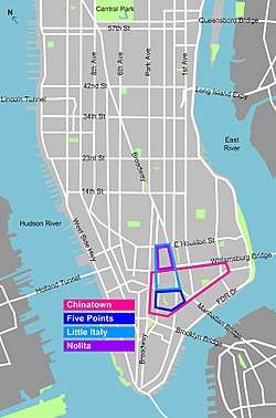
Five Points (or The Five Points) was a 19th-century neighborhood in Lower Manhattan, New York City. The neighborhood was generally defined as being bound by Centre Street to the west, the Bowery to the east, Canal Street to the north, and Park Row to the south. Through the twentieth century, the former Five Points area was gradually redeveloped, with streets changed or closed. The area is now occupied by the Civic Center to the west and south, which includes major federal, state, and city facilities, and the African Burial Ground National Monument. To the east and north, former Five Points area is located within Chinatown.
The Five Points gained international notoriety as a densely populated, disease-ridden, crime-infested slum that existed for well over 70 years.[1]
Name
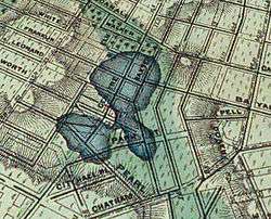
The name "Five Points" was derived from the five-pointed intersection created by Orange Street (now Baxter Street) and Cross Street (now Mosco Street); from this intersection Anthony Street (now Worth Street) began and ran in a northwest direction, dividing one of the four corners into two triangular blocks; thus the fifth "point." To the west of this "point" ran Little Water Street (which no longer exists) north to south, creating a triangular plot which would become known as "Paradise Square," after the buildings standing in the triangle were torn down in 1832.
History
The street grid
The center of the Five Points (south of the bends in the area's north-south streets) is part the inland portion of the Manhattan street grid aligned with the river, and thus was still undeveloped in the early 1700s as the city spread northward.
In 1754, the basic grid began to be shown in plan maps. Orange Street was a two block street running from the "High Road To Boston" (which later became Chatham Street and finally, Park Row), and ended at a small clearing where the later "bend" in the street would occur, which was at this time at the banks of the still unnamed body of "fresh water" to the west, with its surrounding marsh lying ahead to the north.
The future "Five Points" intersection was a normal four-corner crossing of Orange and Cross Streets. Cross Street ran from Mott Street to an unmarked short street where the "Little Water Street" would later be located; the segment between Mott and Mulberry Street still exists as Mosco Street. Orange and Cross Streets ended at the banks of the pond, while Anthony Street (which later completed the "fifth point") did not yet exist.
The area was called the "Out Ward", as the wards were named rather than numbered in this print. (South of this area was "Montgomerie's Ward", and there was also "North", "East", "South", "West" and "Dock" wards, making up the whole city at the time).
Mott and Mulberry Streets were similarly named up to their respective "bends", but had different names north of these points. Mulberry became "Rynderts Street", and Mott became "Winne Street". Elizabeth Street was the same. All three ran to Kevin Street (now Broome Street). Only these three north-south streets and the High Road are drawn this far north. Meanwhile, Bayard Street ended at Rynderts.[2]
A 1776 British map shows the entire area of the intersection, including the stretch where Orange Street should run, from the pond to the High Road (which the British had named "The Road to Kingsbridge, where the rebels mean to make a stand"), and where Cross St. west of Orange should be, as the "Tanners Yards", with eight buildings marked.[3] These tanneries were among what would pollute the pond.
A 1797 map shows that Orange Street had been extended north of the bend; where it continued as Mary Street, which ran to Prince Street. A walkway had been built next to the street, along the pond and its marsh and running from the bend almost to Hester Street. Cross Street was extended and now bent northward and merged into Magazine Street (named after the powder magazines once located there, as shown on the 1776 map), which would later be renamed as an extension of Pearl Street. It is shown crossing what was by then a short creek connecting the main pond with a smaller one to the south. The little street after Orange, next to the pond, was now simply "Water Street" (separate from the other Water Street near the river). There were also multiple "Ann" and "Catherine" streets, one of which was what would become Anthony Street and now ended at the opposite bank of the pond from where Water Street dead-ended.[4] This is called "Cow Bay".
The 1799 map, however, shows Cross Street taking its final alignment, bending slightly southward, crossing Magazine and Duane Streets (known as Barley Street) and running to Read [sic] Street. The smaller southern pond has by now been filled in. This then led into the street which later became Centre Street, which was then known simply as "Potter's Hill" and ended at this intersection.[5]
By the 1807 plan, the entire pond has disappeared, and the whole basic grid is complete through the area. Water Street has actually been extended and renamed "Collect Street", and takes the future alignment of Centre Street north of Leonard Street. At Canal Street (which ended at this street), it then becomes the new "Rynders Street" and then merges with Orange Street at "Broom [sic] St.". Orange ends at a dead end north of Prince Street. Mott and Mulberry have also been renamed for their entire lengths. South of Leonard, a small unnamed street takes the future Centre St. alignment for two blocks, ending at Magazine Street. Anthony Street ends at this street. Cross Street is still the next street running the two blocks between Magazine and "Reed" [sic] Street, and connecting the area to City Hall.
The entire area is now marked as "Sixth Ward".[6]
The "fifth point" was created when Anthony Street was extended to the intersection of Orange and Cross. Centre Street was built through the area, and Collect Street was renamed "Little Water Street", and cut off north of Anthony, recreating the "Cow Bay" dead-end. The encroaching building lines of the new street are what caused the resultant "alleyway" to end up "narrowing...back to a point about a hundred feet from the entrance".[7]
Collect Pond


Poor scientific knowledge and inadequate human understanding of the environmental conditions and appreciation of interconnections followed by substandard development of housing on the reclaimed fill land, resulted in unusually rapid deterioration and partial settling and collapse of the middle class housing and sites. When they left, owners subdivided the rundown sagging houses to absorb the increasing number of urban and immigrant poor. Maintenance and services were minimal, and Five Points developed as a notorious, disease-ridden slum, one of the worst then in the Western World.
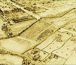
The Collect Pond (or Fresh Water Pond) before being excavated and filled in was a body of spring-fed fresh water, as deep as 60 feet (18 metres) and occupying about 48 acres (194,000 m²). The pond was located in a U-shaped valley with a northwest spur to the Hudson River. The valley was split by a hill the Dutch called Kalk Hoek (Dutch for Chalk Corner), named for the numerous oyster-shell middens left by the indigenous Indian inhabitants. In historic times, this area was occupied by bands of Lenape (also known as the Delaware). The elevation of the site rose in the south, with Pot Bakers Hill dominating the south-southwestern shore.
The pond was located in the eastern section of the valley, east of Kalck Hoek and southwest of Bayard's Mount - at 110 feet (34 metres), the tallest hill in Lower Manhattan. A stream flowed north out of the pond and then northwest to the Hudson River through a salt marsh (which, after being drained, became "Lispenard Meadows"). Another stream, known as the Old Wreck Brook or the Old Kil, flowed southeast through Bestevaer Swamp (later Beekman's Swamp), called Bestevaer Kreupelbosch by the Dutch, to the East River.[9] Werpoes village was located on the southwestern shore of the pond. It had been occupied by a small band of Canarsie, who were Munsee-dialect people—the northernmost division of the Lenape (Delaware) Indians. Gradually they were pushed out by the Dutch settlement of New Amsterdam.[10]
The pond was the main source of drinking water and freshwater fish for the early Town of New York in the 18th century.[11]
Beginning in the early 18th century, various commercial enterprises were built along the pond's shores in order to use the water. The contaminated wastewater from these businesses flowed back into the pond, creating a severe pollution problem and environmental health hazard. Later Pierre Charles L'Enfant, the French born designer of the District of Columbia (later Washington, D.C.) proposed cleaning the pond and making it a centerpiece of a recreational park, around which the residential areas of the city could develop. But his proposal was rejected, and town authorities cheaply decided to fill in the pond, using earth partially obtained from leveling Bayard's Mount and Kalck Hoek. The landfill was completed by 1811, and middle-class townhomes were soon built on the reclaimed land in a tangle of closely packed warren of streets.[12]
The landfill was poorly engineered because of lack of scientific knowledge in that era. The buried vegetation began to release methane gas (a byproduct of decomposition), and the area, still in a natural depression, lacked adequate storm water drains and sewage sewers. As a result, the ground gradually subsided. Houses shifted, settled, sagged and partially collapsed on their foundations, the unpaved streets were often buried in a foot of mud after heavy rains mixed with human and animal excrement, and mosquitos bred in the stagnant pools created by the poor drainage and lack of sanitation, causing malaria and yellow fever diseases to fester as in the Tropics of lower latitudes.
Most middle- and upper-class inhabitants later fled the area in following decades, leaving the neighborhood open to poor immigrants who began arriving in the early 1820s. Landlords divided the housing, greatly increasing the density in the neighborhood. This influx reached a height in the 1840s, with large numbers of Irish Catholic immigrants fleeing the Irish Potato Famine.[13]
Slum
At the height of occupation of Five Points, only certain areas of London's East End vied with it in the western world for population density, disease, infant and child mortality, unemployment, prostitution, violent crime, and other classic ills of the urban destitute. It is sometimes considered the original American melting pot, at first consisting primarily of newly emancipated blacks (gradual emancipation led to the end of slavery in New York on July 4, 1827) and ethnic Irish, who had a small minority presence in the area since the 1600s.[7] The local politics of "the Old Sixth ward" (The Points' primary municipal voting district), while not free of corruption, set important precedents for the election of Catholics to key political offices. Before that time, New York, and America at large, had been governed by the Anglo-Protestant founders. Although there were many tensions between the Africans and the Irish, their cohabitation in Five Points was the first large-scale instance of volitional racial integration in American history.[14] Gradually this African-American community moved to Manhattan's West Side and to undeveloped lands on the north end of the island in the famous Harlem by the early 20th century and across the Harlem River into the South Bronx, as the city developed northward.[15]
Five Points is alleged to have had the highest murder rate of any slum at that time in the world. According to an old New York urban legend, the Old Brewery, formerly Coulthard's Brewery from the 1790s, now an overcrowded tenement on Cross Street housing 1,000 poor, is said to have had a murder a night for 15 years, until its demolition in 1852.[16][17]
"Almack's" (also known as "Pete Williams's Place"), an African American-owned dance hall located at 67 Orange Street in Mulberry Bend (today Baxter Street), just south of its intersection with Bayard Street, was home to a fusion of Irish reels and jigs with the African shuffle.[18][19] Though different ethnic groups interacted in other parts of the United States as well, creating new dance and music forms, in New York this music and dance had spontaneously resulted on the street from competition between African-American and Irish musicians and dancers. It spilled into Almack's, where it gave rise in the short term to tap dance (see Master Juba) and in the long term to a music hall genre that was a major precursor to jazz and rock and roll. This ground is now Columbus Park.
This is the place; these narrow ways diverging to the right and left, and reeking everywhere with dirt and filth. Such lives as are led here, bear the same fruit as elsewhere. The coarse and bloated faces at the doors have counterparts at home and all the world over....
Debauchery has made the very houses prematurely old. See how the rotten beams are tumbling down, and how the patched and broken windows seem to scowl dimly, like eyes that have been hurt in drunken forays. Many of these pigs live here. Do they ever wonder why their masters walk upright instead of going on all fours, and why they talk instead of grunting?—Charles Dickens in American Notes, p. 61
Infectious diseases
Infectious diseases, such as cholera, tuberculosis, typhus, and malaria and yellow fever, had plagued New York City since the Dutch colonial era. The lack of scientific knowledge, sanitation systems, the numerous overcrowded dwellings, and absence of even rudimentary health care made impoverished areas such as Five Points ideal for the development and spread of these diseases. Several epidemics swept the City of New York in the 18th and 19th centuries, some of which originated in Five Points. Others were introduced by passengers disembarking from ships from overseas, including immigrants. In June 1832, an outbreak of cholera in Five Points spread rapidly throughout the crowded, unsanitary dwellings of the neighborhood before spreading to the rest of New York City.[20] With no understanding of disease vectors or transmission, some observers believed that these epidemics were due to the immorality of residents of the slum:
Every day's experience gives us assurance of the safety of the temperate and prudent, who are in circumstances of comfort.... The disease is now, more than before rioting in the haunts of infamy and pollution. A prostitute at 62 Mott Street, who was decking herself before the glass at 1 o'clock yesterday, was carried away in a hearse at half past three o'clock. The broken down constitutions of these miserable creatures, perish almost instantly on the attack.... But the business part of our population, in general, appear to be in perfect health and security.
— "New-York Mercury, July 18, 1832"
Yellow fever epidemics spread with river and ocean-going ships and passengers throughout the southern United States, also affecting as far north as Philadelphia, Baltimore and New York City throughout the late eighteenth and nineteenth centuries.
Riots
Anti-abolitionist riots of 1834
The Anti-abolitionist riots of 1834, also known as the Farren Riots, occurred in New York City over a series of four nights, beginning July 7, 1834. Their deeper origins[21] lay in the combination of nativism and abolitionism among Protestants, who had controlled the city since the American Revolution, and the fear and resentment of blacks among the growing numbers of Irish immigrants, who competed with them for jobs and housing.
In 1827, Great Britain repealed legislation controlling and restricting emigration from Ireland, and 20,000 Irish emigrated. By 1835, more than 30,000 Irish had arrived in New York annually. Among the casualties of the riots was St. Philip's Episcopal Church, the first black Episcopal church in the city, then located at 122 Centre Street. It was sacked and looted by the mostly ethnic Irish mob.
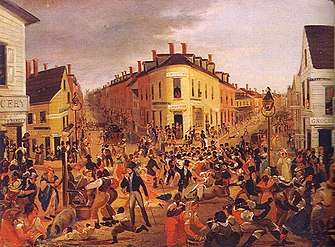
Dead Rabbits Riot (1857)
The New-York Daily Times, July 6, 1857
The media designated a branch of the "Roach Guards", a violent Irish gang, "Dead Rabbits". The Dead Rabbits Riot began when one faction destroyed the headquarters of the Bowery Boys at 26 Bowery, on July 4, 1857. The Bowery Boys retaliated, which led to a large-scale riot which waged back and forth on Bayard Street, between Bowery and Mulberry Street. Rioting resumed on July 5. The Bowery Boys and the Dead Rabbits fought again in front of 40 and 42 Bowery Street (original buildings still extant in May 2017), erecting barricades in the street. On July 6 the Bowery Boys fought the Kerryonians (Irishmen from County Kerry) at Anthony and Centre Street. Historian Tyler Anbinder says the "dead rabbits" name "so captured the imagination of New Yorkers that the press continued to use it despite the abundant evidence that no such club or gang existed". Anbinder notes that, "for more than a decade, 'Dead Rabbit' became the standard phrase by which city residents described any scandalously riotous individual or group." [22]

As residents took advantage of the disorganized state of the city's police force, brought about by the conflict between the Municipal and Metropolitan police, gangsters and other criminals from all parts of the city began to engage in widespread looting and the destruction of property. It is estimated that between 800 and 1,000 gang members took part in the riots, along with several hundred others who used the disturbance to loot the Bowery area. It was the largest disturbance since the Astor Place Riot in 1849. Order was restored by the New York State Militia (under Major-General Charles W. Sandford), supported by detachments of city police. Eight people were reported killed, and more than 100 people received serious injuries.
Social reform and renewal
Various efforts by different charitable organizations and individuals, most Christian themed, attempted to ameliorate the suffering of the poor in Five Points. Padre Felix Varela, a Cuban-born priest, established a Roman Catholic parish—The Church of the Immigrants—in Five Points in 1827, to minister to the poor Irish Catholics. Later renamed the Church of the Transfiguration (Roman Catholic), the parish relocated to the corner of Mott and Cross streets in 1853, when they purchased the building of the Zion Protestant Episcopal Church (c.1801) from its congregation, which moved uptown.
The first call for clearing the slums of Five Points through wholesale demolition came in 1831 from merchants who maintained businesses in close proximity to the neighborhood. Slum clearance efforts (promoted in particular by Jacob Riis, author of How the Other Half Lives, published 1890), succeeded in razing part of Mulberry Bend off Mulberry Street, one of the worst sections of the Five Points neighborhood. It was redeveloped as a park designed by noted landscape architect Calvert Vaux and named Mulberry Bend Park at its opening in 1897; it is now known as Columbus Park.[23]
A major effort was made to clear the Old Brewery on Cross Street, described as "a vast dark cave, a black hole into which every urban nightmare and unspeakable fear could be projected."[7]:67–70 The Old Brewery had formerly been Coulthard's Brewery, which was located on the outskirts of the town less than thirty years earlier in the 1790s. later enveloped by the growing city, it was located on Cross Street just south of the Five Points intersection. The brewery became known as the "Old Brewery" after being converted to a tenement / boarding house in 1837. Its lower, high-ceilinged floor and the above two floors were converted into four floors of rundown apartments. The rent was cheap and attracted many low-income tenants, many of them immigrants. The only census record taken in 1850 reported 221 people living in 35 apartments, averaging 6.3 persons per apartment.[7]:67–70 Accounts conflict as to the total number of people living in the Brewery flats, but all agreed that it was filled to overcapacity.
The poverty seen throughout the Five Points was also displayed at the Old Brewery, and the women of the Home Mission took action. This Methodist charity group was determined to clean up Five Points. The Christian Advocate and Journal reported on the ongoing project in October 1853:
In a meeting held in Metropolitan Hall, in December 1851, such convincing proof was given of the public interest in this project, that the resolution was passed by the Executive Committee to purchase the Old Brewery. Other appeals were made to the public, and nobly met. That celebrated haunt was purchased, in a few months utterly demolished, and already a noble missionary building occupies its site.[24]
The New Mission House replaced the Old Brewery, under the direction of the Five Points Mission. It provided housing, clothes, food, and education as part of the charitable endeavor. The new building had 58 rooms available for living space, twenty-three more than the Old Brewery.
[They] are abridged from enjoying themselves in their sports, from the apprehension... that they may be enticed from the path of rectitude, by being familiarized with vice; and thus advancing step by step, be at last swallowed up in this sink of pollution, this vortex of irremediable infamy....
In conclusion your Committee remark, that this hot-bed of infamy, this modern Sodom, is situated in the very heart of your City, and near the centre of business and of respectable population.... Remove this nucleus—scatter its present population over a larger surface—throw open this part of your city to the enterprise of active and respectable men, and you will have effected much for which good men will be grateful.—Petition to Have the Five Points Opened," Board of Assistant Aldermen documents (October 24, 1831), Municipal Archives, City of New York.[note 3]
Site
Current use
The area formerly occupied by Five Points was gradually redeveloped through the twentieth century. In the west and south, it is occupied by major federal, state, and city administration buildings and courthouses known collectively as Civic Center, Manhattan. In addition Columbus Park, Collect Pond Park, Foley Square, and various facilities of the New York City Department of Corrections are clustered around lower Centre Street. The corrections facilities are the most direct link to the neighborhood's past: the infamous The Tombs jail/prison, in which many criminals from Five Points were incarcerated and quite a few executed, stood near the site of the current "City Prison Manhattan" at 125 White Street. The northeastern and eastern portion of Five Points is now within the sprawling Chinatown. Many tenement buildings dating from the late 19th century still line the streets in this area.
The location of the former "Five Points" intersection and Paradise Square is currently the intersection of Worth (formerly Anthony) and Baxter (formerly Orange) Streets. Mosco (formerly Cross) Street no longer extends to that intersection, having been cut off at Columbus Park. The section of Baxter Street south of Worth Street is no longer a street; it is now the location of the Daniel Patrick Moynihan United States Courthouse. This site also includes the African Burial Ground National Monument, recently established to commemorate the discovery and investigation of the former historic cemetery revealed here by archeological digs after building construction excavations revealed human remains, and the early history of Africans and African Americans in New York Town. Little Water Street was also closed for redevelopment.
Maps
The physical layout of the Five Points intersection changed throughout the 19th and early 20th centuries.
 1776 British map showing the Collect Pond ("Fresh Water"), the canals used to drain the adjacent salt marsh and the tanneries on the eastern shore
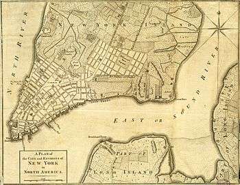
 1800 map with an 1873 street plan overlay the location of future Five Points intersection at lower right of Collect Pond
 1831 map showing Five Points within the Sixth Ward
 1851 map showing Five Points within the Sixth Ward
 1853 map of Five Points intersection showing original street names
 1902 map
Notable people
- John Morrissey, Irish American bare-knuckle boxer, Dead Rabbits gang criminal leader in New York City, Democratic Party New York State Senator, and Tammany Hall-backed U.S. Congressman from New York
In popular culture
Films
- Gangs of New York (2002) is an historical film set in the mid-19th century, in the Five Points district of New York City. The film, directed by Martin Scorsese and written by Jay Cocks, Steven Zaillian, and Kenneth Lonergan, was inspired by Herbert Asbury's nonfiction book, The Gangs of New York (1928). It was made at Cinecittà, Rome, distributed by Miramax Films, and nominated for numerous awards, including the Academy Award for Best Picture.
- The film begins in 1846 and quickly jumps to 1863. The two principal issues of the era in New York were greatly increased Irish immigration to the city and the Union government's issuing a draft call for the American Civil War in 1863.
- The story follows gang leader William "the Butcher" Cutting (Daniel Day-Lewis), a character primarily based on William Poole, in his roles as crime boss and political kingmaker under the helm of "Boss" Tweed (Jim Broadbent). The film culminates in a violent confrontation between Cutting and his mob, on one side, and the protagonist Amsterdam Vallon (Leonardo DiCaprio) and his immigrant allies, on the other, which the film portrays as coinciding with the New York City draft riots of 1863.
- In the film The Sting (1973), mob boss Doyle Lonnegan (Robert Shaw) is known to have come from Five Points. As part of the plan to gain Lonnegan's confidence, Johnny Hooker (Robert Redford) claims to be from the same neighborhood. The movie featured an anachronistic use of the ragtime music of Scott Joplin and stimulated a revival of interest in his work.
- The Japanese manga Green Blood (2011-2013) (グリーン・ブラッド gurīn buraddo), by Kakizaki Masasumi, takes place in Five Points and the surrounding Sixth District after the end of the Civil War, a time of increasing industrialization. The main plot revolves around the gangs and debauchery of the area around that time, showing the severe conditions of life.
Literature
- Solon Robinson's book Hot Corn: Life Scenes in New York Illustrated (1854) had stories about residents of Five Points.
- Edward Rutherfurd's historical fiction novel New York is set, in part, in Five Points.
- May the Road Rise up to Meet You by Peter Troy
- Winter's Tale by Mark Helprin
- The Gods of Gotham by Lyndsay Faye partially takes place here
- Victoria Thompson's Gaslight Mystery series - Murder on Mulberry Bend [25]
Television
- BBC America's drama television series Copper is set in the 1860s in the Five Points neighborhood.
- In Hell on Wheels, season 3, episode 1, Cullen Bohannon and Elam Ferguson go to Five Points to meet with an Irish labor boss; their intention is to recruit workers for the Union Pacific Railroad. The boss' tactics, the scene's set dressing, and the action express the squalor and danger of Five Points in 1867. Ultimately, Bohannon tells a reporter that he didn't much care for the labor bosses he met in New York, and he was hiring laborers directly off the boat, at attractive wages.
Music
- Tom Waits and Kathleen Brennan's song "Never Let Go" contains the line: "down at the Five Points I stand", to suggest an ad extremis emotional and/or physical state.[26]
Gallery
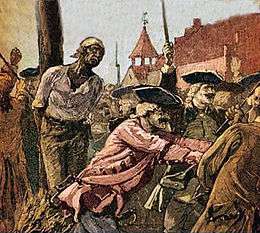 African-American slave being burned at the stake after New York Conspiracy of 1741. 17 black men, two white men, and two white women were hanged at the gibbet next to the Powderhouse on the narrow point of land between the Collect Pond and the Little Collect; 13 were burned at the stake a little east on Magazine Street[27][28]
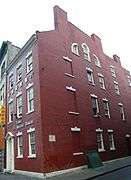 Edward Mooney House built between 1785 and 1789 by wealthy butcher Edward Mooney on the corner of The Bowery and Pell Street on land seized from James Delancey, a British loyalist during the American Revolutionary War
 The Bulls Head Tavern (c. 1755), located approximately at The Bowery and Canal Street, served the thriving slaughterhouse and tannery industry. The area was surrounded by holding pens with slaughterhouses along Mulberry Street[29]
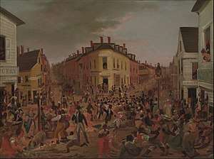 Satirical painting of the Five Points, ca 1827 : "highlighting the district’s renowned chaos and vulgarity, the figures in the painting fight, flirt, and generally misbehave amid dilapidated buildings"[30]
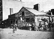 "Home of the Rioters", a corner building that served as a grocery store and liquor store on Baxter and Park streets at the southwest corner of Mulberry Bend in Five Points (c. 1872, Board of Health)
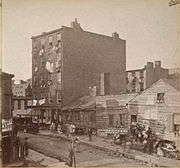 Five Points brick tenements began replacing older wooden buildings; the southwest corner of Mulberry Bend in Five Points with Orange Street running north
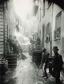
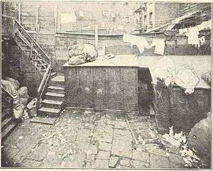 Bottle Alley located in Mulberry Bend just south of Bandit's Roost. A crime scene photograph used in a murder trial. The X marks site where victim was found.
 Five Points House of Industry at 155 Worth Street in 1893 opposite Paradise Square
 Baxter Street Alley, Rag-Picker's Row" at 59 Baxter Street (c. 1898 Jacob Riis)
 Barney Flynn's Old Tree House a bar in the Edward Mooney House in 1899 showing Chuck Connors[31]
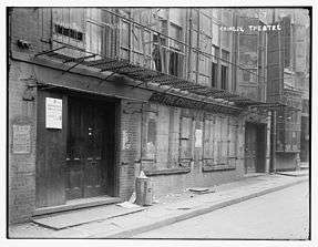 Chinese Theatre 5-7 Doyers Street, scene of multiple murders[32]
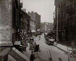
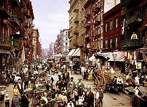 Mulberry Street (c.1900) taken from west side of Mulberry north of Bayard Street looking toward Canal Street
 New York Halls of Justice known as "The Tombs"
 Chinese Tuxedo restaurant at 2 Doyers Street
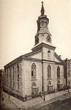 Church of the Transfiguration (built 1801 as Zion Protestant Episcopal Church bought 1853 by Catholic Archdiocese of New York) on the corner of Mott and Mosco Streets. The parish was founded by Padre Félix Varela y Morales in 1827[33]
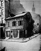 The Black Horse Tavern on the corner of Mulberry and Park Street (now Mosco Street), the Church of the Transfiguration is in the background; picture is c.1895-1899
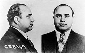 Mugshot of Al Capone-nicknamed "Scarface", was member of the Five Points Gang along with Lucky Luciano
See also
References
Footnotes
- ↑ "Google Maps". google.com.
- ↑ Background information: Merchants owning property along the periphery of Five Points petitioned the municipal government in 1829 to demolish the heart of the slum by widening and extending Anthony and Cross Streets.
- ↑ Columbia University History Online: Petition to Have the Five Points Opened
Notes
- ↑ "The First Slum in America". The New York Times. September 20, 2001.
- ↑ Maerschalck, Francis W. "A plan of the city of New York from an actual survey, anno Domini, M[D]CC,LV". The Library of Congress. Archived from the original on 1981. Retrieved 29 Jun 2018.
- ↑ Digital Collections, The New York Public Library. "(still image) A plan of the city and environs of New York in North America., (1776)". The New York Public Library, Astor, Lennox, and Tilden Foundation. Retrieved June 29, 2018.
- ↑ "A New & Accurate Plan of the City of New York in the State of New York in North America. Published in 1797". Internet Archive. 1797. Retrieved Jun 29, 2018.
- ↑ Goerck, Casimir (1803-11). "A Plan of the City of New York". The New York Public Library Digital Collections. Retrieved Jun 29, 2018. Check date values in:
|date=(help) - ↑ Bridges, William. "Plan of the City of New York, with the recent and intended Improvements, Drawn from actual survey by William Bridges City Surveyor; AD 1807". Geographicus. Retrieved June 29, 2018.
- 1 2 3 4 Anbinder, Tyler (2001). Five Points: The 19th-Century New York City Neighborhood That Invented Tap Dance, Stole Elections, and Became the World's Most Notorious Slum. New York: The Free Press. ISBN 978-0-684-85995-8.
- ↑ Pelletreau, William Smith (1900, reprint 2010). Early New York Houses: With Historical & Genealogical Notes. p. 208. ISBN 1-176-32311-3.
- ↑ Armbruster, Eugene L. (1919, reprinted 2010). The Ferry Road on Long Island. pp. 5–6. ASIN B004IPZE0E.
- ↑ Pritchard, Evan T. Native New Yorkers: The Legacy of the Algonquin People of New York. p. 76.
- ↑ Solis, Julia. New York Underground: The Anatomy of a City. p. 76.
- ↑ Kieran, John. A Natural History of New York. p. 31. ISBN 978-0-8232-1086-2.
- ↑ Delaney, Tim. American Street Gangs. pp. 39, 290. ISBN 978-0-13-305605-1
- ↑ "Gangs of New York". On Location Tours.
- ↑ Timothy J. Gilfoyle (1992). City of Eros: New York City, Prostitution, and the Commercialization of Sex, 1790–1920. W. W. Norton & Company. pp. 41–. ISBN 978-0-393-31108-2. Retrieved 22 March 2013.
- ↑ Blumenthal, Ralph (August 26, 1990). "The City's Rough Past: Frighteningly Familar [sic]". The New York Times. Retrieved August 22, 2009.
- ↑ Walking Guide to New York.
- ↑ Asbury, Herbert. Gangs of New York.
- ↑ Kurlansky, Mark. The Big Oyster: History on the Half Shell. p. 157.
- ↑ Peters, Stephanie True Peters. Cholera: Curse of the Nineteenth Century. p. 26.
- ↑ Burrows, Edwin G.; Wallace Mike (1999). "White, Green and Black", in Gotham: A History of New York City to 1898. pp. 542–562.
- ↑ Tyler Anbinder, Five Points: the 19th-century New York City neighborhood that invented tap dance, stole elections, and became the world's most notorious slum (2001) pp 285-86.
- ↑ "Columbus Park". New York City Department of Parks and Recreation.
- ↑ "The Five Points Mission". Christian Advocate and Journal (1833–1865). 28 (41): 162. October 13, 1853. Retrieved September 6, 2012.
- ↑ http://www.victoriathompson.com/My_Mysteries.html
- ↑ "Tom Waits". tomwaits.com.
- ↑ Digital History: Title: "Fear of Slave Revolts", by Daniel Horsmanden"Archived copy". Archived from the original on June 6, 2011. Retrieved July 16, 2011.
- ↑ New York Times: COLONIAL NEW-YORK CITY; Burning of Negroes Amid the Hills of Five Points. GRIM RESULTS OF AN ALLEGED PLOT The Gibbet on Powder House Island Bore Strange Fruit for Many Months in the Year 1741.
- ↑ Lee, Paula Young. Meat, Modernity, and the Rise of the Slaughterhouse. p. 187.
- ↑ The Five Points, Metropolitan Museum of Art Database
- ↑ "Chuck' Connors Dies on Bowery; Pneumonia Ends Career of the Famous Chinatown Guide and Inventor of Slang". The New York Times.
- ↑ "Three Shot Dead in Chinese Theatre; Hip Sing Tongs Fire Upon the On Leong Tongs". The New York Times.
- ↑ Church of Zion and St. Timothy (Protestant Episcopal)
Bibliography
- Anbinder, Tyler (April 2002). "From Famine to Five Points: Lord Lansdowne's Irish Tenants Encounter North America's Most Notorious Slum". The American Historical Review. American Historical Association. 107 (2): 351–387. doi:10.1086/532290. Archived from the original on October 16, 2008. Retrieved 27 October 2014.
- Anbinder, Tyler (2001). Five Points: The 19th-Century New York City Neighborhood That Invented Tap Dance, Stole Elections, and Became the World's Most Notorious Slum. New York: The Free Press. ISBN 978-0-684-85995-8.
External links
| Wikimedia Commons has media related to Five Points, Manhattan. |
| Wikisource has original text related to this article: |
- Chitiano, Gregory. "Where the Gangs Lived-New York's Five Points". urbanography.com. Archived from the original on August 24, 2011.
- "Five Points". GSA.gov. Official site of the federal government's Five Points archaeological dig
- Article including contemporary news accounts of 1857 Police and Gang Riots
- "Frances Carle (Asbury)". Herbert Asbury. 2004.
- "Five Points". History of NY Chinatown. Includes a map of the area then, and now.
| Lower Manhattan below 14th St (CB 1, 2, 3) |
|   |
|---|---|---|
| Midtown (CB 5) | ||
| West Side (CB 4, 7) | ||
| East Side (CB 6, 8) | ||
| Upper Manhattan above 110th St (CB 9, 10, 11, 12) | ||
| Islands |
| |
| Former | ||
Coordinates: 40°42′52″N 74°00′01″W / 40.71444°N 74.00028°W