Inwood, Manhattan

Inwood is a neighborhood in the New York City borough of Manhattan, at the northern tip of Manhattan Island, in the U.S. state of New York.
History
.jpg)
On May 24, 1626, according to legend,[1] Peter Minuit, the director general of the Dutch colony of New Netherland, bought the island from the Lenape Indians for 60 Dutch guilders and, the story goes, some trinkets.[2] On the southern tip of the island Minuit founded New Amsterdam. A plaque (on a rock) marking what is believed to be the spot of the sale is in Inwood Hill Park, the only natural forest left in Manhattan.
During the British occupation of Manhattan in the American Revolutionary War, there was an encampment containing more than sixty huts occupied by Hessian troops between 201st and 204th Streets along Payson Avenue. The camp was discovered in 1914 by local archeologist and historian Reginald Bolton after a series of digs around the neighborhood.[3]
Inwood was a very rural section of Manhattan well into the early 20th century. Once the IRT Broadway – Seventh Avenue Line, the modern 1 train, reached Inwood in 1906, speculative developers constructed numerous apartment buildings on the east side of Broadway. Construction continued into the 1930s, when the IND Eighth Avenue Line, the modern A train, reached Dyckman and 207th Streets along Broadway and the large estates west of Broadway (Seaman, Dyckman, Isham, etc.) were sold off and developed. Many of Inwood's impressive Art Deco apartment buildings were constructed during this period. The area around Dyckman Street and 10th Avenue formerly contained a stadium called the Dyckman Oval, with a capacity of 4,500 spectators, which hosted football games, boxing matches, and Negro League baseball games until it was replaced by public housing in the 1950s.
Geography and geology

Inwood is physically bounded by the Harlem River to the north and east, and the Hudson River to the west. It extends southward to Fort Tryon Park and alternatively Dyckman Street or Fairview Avenue farther south, depending on the source.[4][5]
(While Inwood is the northernmost neighborhood on the island of Manhattan, it is not the northernmost neighborhood of the entire borough of Manhattan. That distinction is held by Marble Hill, a neighborhood situated just north of Inwood, on what is properly the North American mainland bordering the Bronx. Marble Hill was isolated from Inwood and the rest of Manhattan in 1895 when the route of the Harlem River was altered by the construction of the Harlem River Ship Canal.)
Because of its water boundary on three sides, its hilly geography, and its limited local street connections (only Broadway and Fort George Hill connect to the rest of the Manhattan street grid), the neighborhood can feel somewhat physically detached from the rest of the borough. The W.P.A. Guide to New York City, published in the 1930s, described Inwood with "rivers and hills insulate a suburban community that is as separate an entity as any in Manhattan."[6]
Inwood marble, a soft, white, metamorphic rock found in northern Manhattan, takes its name after the neighborhood. From the mid-17th to the late 18th century, commercial quarries dotted the area as the material was used for building construction. However, due to its susceptibility to erosion, builders eventually used alternate construction materials.[7] Inwood marble was quarried for government buildings in lower Manhattan and Washington, D.C. Small pieces of marble can still be seen in the stone retaining walls around Isham Park.
The seismologically active Dyckman Street Fault runs east-west beneath the Dyckman Valley. As recently as 1989, activity of this fault caused a magnitude 2 earthquake.[8][9][10]
Land use
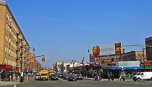
Commercial retail uses are mainly located along Broadway, Dyckman Street and West 207th Street. In recent years Dyckman Street west of Broadway has become a popular entertainment district with many restaurants and lounges. Offices are typically located on second floors over retail, or in the neighborhood's sole office building (a converted telephone building) at Broadway and West 215th Street. Inwood also contains one of Manhattan's few remaining C-8 zoning districts, which concentrates automotive uses on the northern stretches of Broadway.
Industrial uses, including subway (207th Street Yard), bus (Kingsbridge Bus Depot), and sanitation (Manhattan North) depots, exist primarily along Sherman Creek, an inlet of the Harlem River. The creek and surrounding industrial area is bounded by Dyckman Street to the south, Tenth Avenue to the west, and 207th Street to the north. There has been an initiative among politicians over the last few years to re-zone this area for residential and commercial use, and to create public access to the waterfront.[11] Currently, Con Ed and the City of New York own some of the property in this area.
The major residential land use in Inwood is multifamily five- to eight-story prewar apartment buildings. New construction is rare. Most of the remaining detached and semi-detached houses on Manhattan Island are located in Inwood, nestled between apartment buildings. Adjacent to Sherman Creek is Inwood's public housing development, known as the Dyckman Houses and constructed in 1951.
Institutions and landmarks

Most visitors get their first glimpse of the neighborhood when visiting the area's best known cultural attraction, The Cloisters in Fort Tryon Park. This branch of the Metropolitan Museum of Art is devoted to Medieval art and culture, and is located in a medieval-style building, portions of which were purchased in Europe, brought to the United States, and reassembled. Whether the museum itself is actually located in Inwood depends on one's definition of the neighborhood boundaries but its tower dominates the skyline of the area and the museum can be easily accessed via steep pathways leading up from Dyckman Street.


From Inwood Hill Park, one can view a 100-foot (30 m)-tall Columbia "C" painted on the face of a rock cut across the Harlem River on the Bronx shore. This collegiate logo has been in place for approximately a half-century, though it is not clear who exactly maintains the painted letter in the present day. Looking west from Inwood Hill Park across the Hudson River, one can view the New Jersey Palisades. Looking east from Inwood, the former NYU campus in University Heights, Bronx, now Bronx Community College, towers above the east end of the University Heights Bridge.
Bridges spanning Spuyten Duyvil Creek include the Henry Hudson Bridge, the longest fixed arch bridge in the world when built in 1936, and the Spuyten Duyvil Bridge, a railroad swing bridge reconstructed numerous times since originally opening in 1849. Road bridges are the Broadway Bridge and the University Heights Bridge, both important local structures.
The local hospital in Inwood is the Allen Hospital, a satellite facility of NewYork-Presbyterian Hospital.
The oldest building in Inwood is the Dyckman House, the oldest farmhouse in Manhattan, on Broadway at 204th Street.
A farmers' market takes place on Isham Street on Saturdays, year-round.
The Seaman-Drake Arch, located on Broadway at 216th Street, is one of only two free-standing arches in Manhattan, the other being the Washington Square Arch. The Seaman-Drake Arch was built in 1855 of local Inwood marble. It is the last remaining structure of the mansion that formerly stood there.[12]
At the North Cove at 207th Street and the Harlem River, both the shoreline and the water just off it have been rehabilitated from their former derelict polluted state by James Cataldi (also known as the "Birdman of Inwood") into a flourishing wetland teeming with geese, ducks, and other varities of fowl.[13]
Real estate
Inwood's real estate rents and values are sharply bifurcated between east and west. According to Manhattan Community Board 12, the districts east of Broadway are predominantly lower-income. This area is also more industrial and commercial and has fewer parks and street trees. Real estate values and rents are correspondingly lower than the area west of Broadway. Almost all of Inwood's co-ops and all of the private houses are located on the west side of Broadway.[14]
In 2015, New York City began soliciting community comments on a major rezoning proposal for Inwood. The New York City Economic Development Corporation proposed to alter the area's 50-year-old current zoning plan by dividing Inwood into five sub-districts called "the tip of Manhattan", "Upland Wedge", "Upland Core", "Commercial U" and "Sherman Creek". Some of these sub-districts would be rezoned to encourage the construction of new commercial space and housing. The rezoning proposal has triggered much feedback from the community.[15] In August 2018, the New York City Council approved a measure to rezone the neighborhood.[16]
Parks

Inwood Hill Park, on the Hudson River, is a very large and old-growth forested city park. It is known for its caves that were used by the Lenape before Europeans arrived, and the last salt marsh in Manhattan. Birdwatchers come to the Park to see waterbirds, raptors, and a wide variety of migratory birds. The wooded section, consisting mostly of abandoned former summer estates, features the last natural forest standing on Manhattan Island. A busy ballfield complex, tennis courts, three playgrounds, a waterfront promenade and extensive hiking trails are also prominent components of the Park.
Columbia University's 23-acre (93,000 m2) athletic fields have been located in Inwood since the 1920s. They are known today as the Baker Athletics Complex, though locals still use the historical name of "Baker Field". The football stadium within the complex, officially Robert K. Kraft Field at Lawrence A. Wien Stadium, can accommodate 17,000 fans and was noted by Sports Illustrated as "one of the most beautiful places in the country to watch a football game" due to the scenic views of the Henry Hudson Bridge and the New Jersey Palisades from the home stands.[17] In January 2014, a new one-acre park called Muscota Marsh opened to the public between Inwood Hill Park and Baker Field as part of an agreement with the city for the development of the Campbell Athletic Center at West 218th Street and Broadway. This waterfront park was built by Columbia and is jointly administered by the city parks department and the university.[18] The Inwood waterfront is also home to Columbia University's Boathouse - the "1929 Boathouse" which stands next to the "Gould-Remmer Boathouse" which was originally constructed in 1895 as the Gould Boathouse at 116th Street on the Hudson River and was relocated here in 1989. This new structure now houses the Ivy League school's Crew team and hosts inter-collegiate rowing competitions.[19] In July of 2018 a Harbor Seal nicknamed "Sealy" showed up by the structure and has as thus far stayed around and found itself a popular neighborhood attraction and magnet for media attention.[20]
Other parks in or adjoining Inwood are Isham Park, Sherman Creek Park (Swindler Cove), Fort Washington Park, Fort Tryon Park, and Highbridge Park. The Lt. William Tighe Triangle, aka the Riverside-Inwood Neighborhood Garden (RING), is the northernmost piece of Ft. Tryon Park and lies at the confluence of Riverside Drive, Dyckman Street, Broadway, and Seaman Avenue.[21] It is Inwood's oldest community garden, having been founded in 1984. Bruce's Garden is another notable community garden, located in the northeast corner of Isham Park.
Demographics
The residents of Inwood were substantially of Irish descent for much of the 20th century. The neighborhood exhibited a strong Irish identity with many Irish shops, pubs, and even a Gaelic football field in Inwood Hill Park. The second-largest group during this time was the Jewish population, an extension of the large Jewish population of Washington Heights. However, in the 1960s through the 1980s, many Irish and Jewish residents moved out of Inwood to the outer boroughs (for example, Riverdale and Spuyten Duyvil in the Bronx) and the suburbs, in a pattern consistent with overall trends in the city at that time. During the same period that the Irish were leaving Inwood, there was a rise in the number of Dominican immigrants to the area.
Today, Inwood has a predominantly Dominican population, especially in the areas east of Broadway. Hispanic residents make up 74 percent of Inwood's population as a whole, according to census data.[22] A few Irish remain in the blocks near the Church of the Good Shepherd at Isham Street, though even its Mass services are now offered in Spanish nearly as often as in English. The YMHA remains, but the former synagogues have now been converted to churches and other uses.
Crime
Inwood is patrolled by the New York City Police Department's 34th Precinct. At one time, Inwood had one of the city's highest crime rates. From 1993 to 2010, crime decreased by 83%. Inwood became one of Manhattan's safest neighborhoods in 2010, and was the city's 17th-safest neighborhood that year.[23] Grand larceny auto incidents have seen the greatest decrease from 1993 to 2010: a 95% decrease to 97 incidents in 2010. This was followed by incidences of burglary, down 90% to 190 in 2010. Shooting incidents and murders dropped 90% to nine shootings and four murders in 2010.[23]
Crime has gone down since the 1990s. Still, certain types of crimes have increased; for example, muggings and other attacks near Isham Park and area subway stations have gone up.[23] Violent crimes are a problem in the neighborhood, as murders, rapes, robberies, and felony assaults were all up in both 2009 and 2010. In 2010, rapes rose 29%, to 22, and misdemeanor sex crimes rose 24%, to 26. In that period, though, overall crime went down 3%.[23]
In 2014, crime rates dropped. That year, there was one murder, 13 rapes, 224 robberies, 204 felony assaults, 177 burglaries, 456 grand larcenies, and 76 grand larceny autos in the 34th Precinct.[24]
Transportation
Inwood's main local thoroughfare is Broadway, which is co-designated US 9 at this point. Highway access to the area is via the Henry Hudson Parkway to the west, the Harlem River Drive to the southeast (ending at Dyckman Street), and the Alexander Hamilton Bridge over the Harlem River from the Trans-Manhattan Expressway to the Cross Bronx Expressway (both of which carry I-95 and U.S. 1). Other bridges to the area include the Washington Bridge at 181st Street, crossing the Harlem River to the Bronx; the University Heights Bridge, from 207th Street in Manhattan across the Harlem River to Fordham Road in the Bronx; the Broadway Bridge, across the Spuyten Duyvil Creek north to Marble Hill; and the Henry Hudson Bridge across Spuyten Duyvil Creek to the Bronx. Inwood's main commercial shopping streets are Broadway, Dyckman Street, and West 207th Street. Manhattan's first Slow Zone was installed on the side streets west of Broadway in 2012; it is similar to other Slow Zones citywide installed as part of Vision Zero, which commenced under Mayor Bill de Blasio in 2014.[25]

The majority of neighborhood residents commute via the subway using either the A train at the 207th Street or Dyckman Street stations along Broadway, the latter of which was a subway terminus since it opened in 1932 and was renovated in 1999 to be ADA accessible.[26][27] The neighborhood also is served by the 1 train at the Dyckman Street, 207th Street, or 215th Street stations along Tenth Avenue.
The Metro-North Railroad's Hudson Line has a station just over the Broadway Bridge at Marble Hill as well as across the University Heights Bridge in University Heights, providing an additional commuting options (discounted on weekends using CityTicket).
Inwood is also served by the M100, Bx12, Bx12 SBS, Bx20 local buses and the BxM1 express bus. All MTA Regional Bus Operations routes except the Bx7 terminate in the neighborhood.[28] The median commute time for all residents is approximately 45 minutes, with 72.5% of Inwood's residents working within New York County.[26]
Bike infrastructure in Inwood is limited. Painted lanes are located on Seaman Avenue and the far eastern portion of Dyckman Street. West 218th Street is marked with sharrows (shared lane markings). The Manhattan Waterfront Greenway can be accessed from Inwood on both the Hudson and Harlem River sides; in addition, a 0.75-mile (1.21 km) dead-end stub along the Hudson waterfront below Dyckman Street was added in 2014. Technically, there is a ban on bicycles in Inwood Hill Park except for its western edge and the Henry Hudson Bridge. The Broadway Bridge requires cyclists to use the steel-grate roadway, making cycling connections to the Bronx difficult.
Education

Inwood (and Fort George, depending on how one considers neighborhood boundaries) hosts various public schools:
- PS 5 The Ellen Lurie School, a K–5 public school
- PS/IS 18 Park Terrace, a K–8 public school
- PS 98 Shorac Kappock, a K–5 public school
- PS 152 Dyckman Valley, a K–5 public school
- PS 178 Juan Bosch School, a K–2 public school (expanding to Grade 5)
- IS 52 Inwood JHS, a 6–8 public school
- The Paula Hedbavny School, a K–8 public school
- MS 322], a 6–8 public school
- High School for Excellence and Innovation, a 9–12 public specialty school
- Three public schools are "schools of choice" for District 6 and admit by lottery:
- Muscota New School, a K–5 progressive public school
- PS/IS 311 Amistad Dual Language School, a K–8 English/Spanish dual language public school
- PS 366 Washington Heights Academy, a K–8 public school
- There is one public charter school located in Inwood: Inwood Academy for Leadership Charter School, a 5–9 public charter school (expanding each year)
There are several private religious schools in Inwood:
- Good Shepherd School, a PK–8 Roman Catholic school
- Manhattan Christian Academy, a PK–8 nondenominational Christian school
- Northeastern Academy, a 9–12 Seventh Day Adventist high school
- Our Lady Queen of Martyrs School, a PK–8 Roman Catholic school
There is one higher-education classroom campus in Inwood:
Notable residents
Notable current and former residents of Inwood include:
- Kareem Abdul-Jabbar (born 1947), former NBA basketball star, grew up in the Dyckman Houses as Lew Alcindor.[29]
- Jim Carroll (1950–2009), author of The Basketball Diaries, an autobiography set in 1960s Inwood which was adapted into a film in 1995 starring Leonardo DiCaprio.[30]
- Astronomer, planetarium director and author Thomas Wm. Hamilton (born 1939) lived on Seaman Avenue from 1942 to 1968. Noted as the namesake of asteroid 4897 Tomhamilton.
- Wynn Handman (born 1922), Artistic Director of The American Place Theatre.[31]
- Bess Houdini (1876–1943), wife of magician and stunt performer Harry Houdini lived at 67 Payson Avenue and conducted seances to contact him after his death.[32]
- Brian Lehrer (born 1952), radio host on WNYC.[33]
- Lionel Mapleson (1865–1937), violinist and librarian of the Metropolitan Opera House for nearly 50 years. Creator of the Mapleson Cylinders, one of the earliest recordings of live classical music. Mapleson lived on Park Terrace East at the time of his death.[34]
- Anthony Marx, current president and CEO of the New York Public Library.[35]
- Will McIntosh (born 1962), Winner of the 2010 Hugo Award for Best Short Story.
- Lin-Manuel Miranda (born 1980), actor and writer of the Broadway musicals In the Heights and Hamilton.[36]
- Paul Stanley (born 1952), musician and co-founder of the American rock band Kiss, was born in Inwood and lived in the neighborhood until age 8.[37]
- Henry Stern (born 1935), longtime former Commissioner of the New York City Department of Parks and Recreation.[38]
- Isidor Straus (1845–1912), owner of Macy's department store, owned a country estate that was located in present-day Inwood Hill Park[39]
References
- ↑ "Where Did the Manhattan 'Purchase' Take Place?," New Netherland Institute
- ↑ ""Peter Minuit," Britannica Online". Encyclopædia Britannica. Retrieved 28 October 2014.
- ↑ "Archived copy". Archived from the original on 2011-07-23. Retrieved 2011-03-21.
- ↑ Jackson, Nancy Beth. "If You're Thinking of Living In/Inwood; Away From Manhattan Without Leaving", The New York Times, December 15, 2002. Accessed October 23, 2008. "The neighborhood's southern boundary with Washington Heights depends on who's defining. Residents line up in two camps: Fairview Avenue as described in the Encyclopedia of New York City and Dyckman Street( Most Common), about a half-dozen blocks to the north, on Department of City Planning maps. Real estate agents seem to agree with the encyclopedia."
- ↑ Russo, Francine. "Close Up On: Inwood", The Village Voice, October 15, 2002. Accessed October 23, 2008. "Boundaries: Fairview Avenue to the south, Dyckman Street to the west, and the Harlem River to the north and east (Inwood is bisected by Broadway)."
- ↑ Federal Writers' Project (1939). New York City: Vol 1, New York City Guide. US History Publishers. pp. 302–306. ISBN 978-1-60354-055-1.
- ↑ "Secrets of New York" Podcast, "Facelift: Inwood Hill, Harlem River Ship Canal, Secret of Marble Hill Episode"
- ↑ Fennell, Ryan (November 30, 1989). "Could It Happen Here? Earthquakes In The Tri-State Area". Two River Times. Archived from the original on July 19, 2011.
- ↑ Sykes, Lynn R.; et al. (August 2008). "Observations and Tectonic Setting of Historic and Instrumentally Located Earthquakes in the Greater New York City–Philadelphia Area" (PDF). Bulletin of the Seismological Society of America, Vol. 98, No. 4, pp. 1696–1719.
- ↑ Shahid, Alihay (March 17, 2011). "Could an earthquake hit New York City? History says yes, but not like 9.0 magnitude Japan earthquake". New York Daily News.
- ↑ "Sherman Creek initiative at nyc.gov". Archived from the original on 18 October 2014. Retrieved 28 October 2014.
- 1 2 "The Inwood Arch and Mansion: Circa 1896". myinwood.net. Retrieved 1 June 2015.
- ↑ https://cityroom.blogs.nytimes.com/2011/05/04/bird-week-birdman-of-inwood/
- ↑ "Archived copy" (PDF). Archived from the original (PDF) on 2013-04-20. Retrieved 2013-04-07.
- ↑ Pichardo, Carolina (2017-07-20). "5 Takeaways From the Inwood Rezoning Proposal". DNAinfo. Archived from the original on 2017-10-08. Retrieved 2018-10-05.
- ↑ Walker, Ameena (August 8, 2018). "Inwood rezoning will move forward with City Council approval". Curbed NY. Retrieved October 5, 2018.
- ↑ "Columbia Athletics".
- ↑ Foderaro, Lisa W. (20 January 2014). "With University's Help, New Park on Harlem River Is a Marshland Sanctuary". The New York Times. Retrieved 10 February 2014.
- ↑ https://gocolumbialions.com/sports/2018/6/5/204983627.aspx
- ↑ https://www.nbcnewyork.com/news/local/Seal-lonely-sealy-upper-manhattan-muscota-marsh-new-york-489903741.html
- ↑ "RING Garden". RING Garden. Retrieved 28 October 2014.
- ↑ Beyer, Gregory (March 1, 2009). "Northern Zone, South-of-the-Border Flavor". The New York Times.
- 1 2 3 4 "Inwood". DNA Info Crime and Safety Report. Archived from the original on 6 August 2015. Retrieved 11 August 2015.
- ↑ 34th Precinct CompStat, NYPD (August 11, 2015)
- ↑ Carla Zanoni (June 11, 2012). "Inwood Traffic Could Put on the Brakes Under Neighborhood Slow Zone". DNAInfo. Archived from the original on November 9, 2014. Retrieved October 27, 2014.
- 1 2 "10034 Zip Code (New York, New York) Profile - homes, apartments, schools, population, income, averages, housing, demographics, location, statistics, sex offenders, residents and real estate info". Retrieved 28 October 2014.
- ↑ "www.nycsubway.org". www.nycsubway.org. Retrieved 28 October 2014.
- ↑ http://mta.info/nyct/maps/manbus.pdf
- ↑ New York Magazine."Childhood in New York". Accessed June 16, 2015.
- ↑ Entertainment Weekly. "Jim Carroll Cool Poet". Accessed March 24, 2008.
- ↑ Ryzik, Melena. "Nearly 60 Years and Counting, Working on the Art of Theater", The New York Times, May 20, 2007. "He grew up in Inwood, on a dirt road, fishing for crabs off a dock on Dyckman Street. "I had a country boyhood in Upper Manhattan," he said."
- ↑ "Reports Message of Houdini Decoded". The New York Times, January 9, 1929.
- ↑ Ungar-Sargon, Batya. "Hello, Brian Lehrer? This Is All of New York On the Line.The longtime host of NPR flagship WNYC’s morning call-in show talks about being a radio mensch, Rush Limbaugh, and city politics", Tablet (magazine), July 5, 2013. Accessed January 28, 2017. "Born in Queens to parents from the South Bronx who met in high school, Lehrer, 60, now lives in Inwood with his wife and two kids."
- ↑ Lionel S. Mapleson, Opera's Librarian; Served Metropolitan Nearly Half Century-Victim of Heart Attack. The New York Times. Dec. 23, 1937.
- ↑ NYPL. .
- ↑ Melena Ryzik. "Heights before Broadway". The New York Times. Accessed March 24, 2008.
- ↑ Oliveri, Kristen. "KISS' Stanley, Simmons Unveil Restaurant Chain Expansion", The Daily Meal, January 20, 2005. Accessed January 28, 2017. "Stanley was born in the Inwood neighborhood of Manhattan in New York City to a German mother and a first-generation Polish father who made sure the family understood the value of a decent meal."
- ↑ Bumiller, Elisabeth. "Guarding the Turf, Stepping on Toes; Henry Stern, Passionate and Blunt, Champions the City Parks", The New York Times, July 23, 1995. Accessed October 28, 2007. "There are a few other key things that define Mr. Stern. He grew up in Inwood, a mixture of Jewish, Irish and Greek immigrants several generations ago but now a largely Dominican neighborhood."
- ↑ Yarrow, Andrew L. "EXPLORING INWOOD HILL'S URBAN WILDERNESS", The New York Times, May 1, 1987. Accessed January 28, 2017. "Isidor Straus, the founder of Macy's who died on the Titanic, built a huge house some 200 feet above the Hudson; the site is now a meadow where lilacs and privets grow, and a few ruined walls from the estate are clad with vines. In the early 1900's, the area was dotted also with various hospitals, asylums and homes for 'wayward' girls."
External links
| Wikimedia Commons has media related to Inwood, Manhattan. |
| Lower Manhattan below 14th St (CB 1, 2, 3) |
|   |
|---|---|---|
| Midtown (CB 5) | ||
| West Side (CB 4, 7) | ||
| East Side (CB 6, 8) | ||
| Upper Manhattan above 110th St (CB 9, 10, 11, 12) | ||
| Islands |
| |
| Former | ||