Chalaronne
| Chalaronne | |
|---|---|
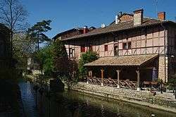 The Chalaronne at Châtillon-sur-Chalaronne | |
| Country | France |
| Physical characteristics | |
| Main source |
Lapeyrouse 280 m (920 ft) 45°58′04″N 04°59′54″E / 45.96778°N 4.99833°E |
| River mouth |
Saône 170 m (560 ft) 46°09′54″N 04°47′31″E / 46.16500°N 4.79194°ECoordinates: 46°09′54″N 04°47′31″E / 46.16500°N 4.79194°E |
| Length | 52 km (32 mi) |
| Discharge |
|
| Basin features | |
| Progression | Saône→ Rhône→ Mediterranean Sea |
| Basin size | 175 km2 (68 sq mi) |
The Chalaronne (French: la Chalaronne) is a 52 km (32 mi) long river in the Ain département, eastern France. Its source is at Lapeyrouse, in the Dombes. It flows generally northwest. It is a left tributary of the Saône into which it flows between Saint-Didier-sur-Chalaronne and Thoissey.
Communes along its course
This list is ordered from source to mouth: Lapeyrouse, Birieux, Villars-les-Dombes, Bouligneux, La Chapelle-du-Châtelard, Marlieux, Saint-Germain-sur-Renon, Sandrans, Romans, Châtillon-sur-Chalaronne, L'Abergement-Clémenciat, Dompierre-sur-Chalaronne, Saint-Étienne-sur-Chalaronne, Saint-Didier-sur-Chalaronne, Thoissey,
Notes
- This article is based on the equivalent article from the French Wikipedia, consulted on April 10th 2009.
References
This article is issued from
Wikipedia.
The text is licensed under Creative Commons - Attribution - Sharealike.
Additional terms may apply for the media files.