McIntosh County, North Dakota
| McIntosh County, North Dakota | |
|---|---|
 McIntosh County Courthouse in Ashley | |
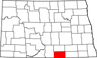 Location in the U.S. state of North Dakota | |
 North Dakota's location in the U.S. | |
| Founded | October 4, 1884 |
| Seat | Ashley |
| Largest city | Wishek |
| Area | |
| • Total | 995 sq mi (2,577 km2) |
| • Land | 975 sq mi (2,525 km2) |
| • Water | 20 sq mi (52 km2), 2.0% |
| Population (est.) | |
| • (2016) | 2,656 |
| • Density | 2.9/sq mi (1.1/km2) |
| Congressional district | At-large |
| Time zone | Central: UTC−6/−5 |
McIntosh County is a county located in the U.S. state of North Dakota. As of the 2010 census, the population was 2,809.[1] Its county seat is Ashley.[2] The county was created in 1883 and later organized in 1884.[3][4]
History
McIntosh County was created by the 1883 territorial legislature after the southern half of Logan County was divided. The name refers to Edward H. McIntosh, a member of the legislature at the time.[4] The county seat was originally Hoskins, but changed in 1888 after everything in Hoskins but the school was moved three miles east to the new Soo Line Railroad townsite of Ashley.[5]
Geography
According to the U.S. Census Bureau, the county has a total area of 995 square miles (2,580 km2), of which 975 square miles (2,530 km2) is land and 20 square miles (52 km2) (2.0%) is water.[6]
Adjacent counties
- Logan County (north)
- LaMoure County (northeast)
- Dickey County (east)
- McPherson County, South Dakota (south)
- Campbell County, South Dakota (southwest)
- Emmons County (west)
Major highways


Demographics
| Historical population | |||
|---|---|---|---|
| Census | Pop. | %± | |
| 1890 | 3,248 | — | |
| 1900 | 4,818 | 48.3% | |
| 1910 | 7,251 | 50.5% | |
| 1920 | 9,010 | 24.3% | |
| 1930 | 9,621 | 6.8% | |
| 1940 | 8,984 | −6.6% | |
| 1950 | 7,590 | −15.5% | |
| 1960 | 6,702 | −11.7% | |
| 1970 | 5,545 | −17.3% | |
| 1980 | 4,800 | −13.4% | |
| 1990 | 4,021 | −16.2% | |
| 2000 | 3,390 | −15.7% | |
| 2010 | 2,809 | −17.1% | |
| Est. 2016 | 2,656 | [7] | −5.4% |
| U.S. Decennial Census[8] 1790-1960[9] 1900-1990[10] 1990-2000[11] 2010-2016[1] | |||
2000 census
| Languages (2000) [12] | Percent |
|---|---|
| Spoke English at home | 64.34% |
| Spoke German at home | 35.54% |
| Spoke Spanish at home | 0.12% |
As of the census of 2000, there were 3,390 people, 1,467 households, and 975 families residing in the county. The population density was 4 people per square mile (1/km²). There were 1,853 housing units at an average density of 2 per square mile (1/km²). The racial makeup of the county was 98.88% White, 0.15% Native American, 0.29% Asian, 0.03% Pacific Islander, 0.09% from other races, and 0.56% from two or more races. 0.83% of the population were Hispanic or Latino of any race. 82.2% were of German and 5.0% American ancestry.
There were 1,467 households out of which 22.30% had children under the age of 18 living with them, 60.30% were married couples living together, 3.50% had a female householder with no husband present, and 33.50% were non-families. 32.00% of all households were made up of individuals and 19.90% had someone living alone who was 65 years of age or older. The average household size was 2.19 and the average family size was 2.75.
In the county, the population was spread out with 19.40% under the age of 18, 4.60% from 18 to 24, 19.40% from 25 to 44, 22.40% from 45 to 64, and 34.20% who were 65 years of age or older. The median age was 51 years. For every 100 females there were 91.50 males. For every 100 females age 18 and over, there were 91.70 males.
The median income for a household in the county was $26,389, and the median income for a family was $31,771. Males had a median income of $22,153 versus $16,743 for females. The per capita income for the county was $15,018. About 10.60% of families and 15.40% of the population were below the poverty line, including 14.50% of those under age 18 and 18.90% of those age 65 or over.
2010 census
| Languages (2010) [12] | Percent |
|---|---|
| Spoke English at home | 74.22% |
| Spoke German at home | 24.70% |
| Spoke Spanish at home | 0.94% |
| Spoke a Scandinavian language at home | 0.11% |
| Spoke French at home | 0.04% |
As of the 2010 United States Census, there were 2,809 people, 1,307 households, and 800 families residing in the county.[13] The population density was 2.9 inhabitants per square mile (1.1/km2). There were 1,858 housing units at an average density of 1.9 per square mile (0.73/km2).[14] The racial makeup of the county was 98.1% white, 0.4% Asian, 0.4% American Indian, 0.2% black or African American, 0.2% from other races, and 0.6% from two or more races. Those of Hispanic or Latino origin made up 1.4% of the population.[13] In terms of ancestry, 76.8% were German, 26.9% were Russian, 6.2% were Norwegian, and 5.2% were American.[15]
Of the 1,307 households, 19.4% had children under the age of 18 living with them, 55.0% were married couples living together, 3.5% had a female householder with no husband present, 38.8% were non-families, and 36.2% of all households were made up of individuals. The average household size was 2.07 and the average family size was 2.66. The median age was 52.7 years.[13]
The median income for a household in the county was $34,904 and the median income for a family was $46,198. Males had a median income of $35,200 versus $23,594 for females. The per capita income for the county was $22,608. About 9.2% of families and 13.9% of the population were below the poverty line, including 9.7% of those under age 18 and 20.2% of those age 65 or over.[16]
Politics
McIntosh County is a powerfully Republican county. The only Democrats to carry McIntosh County have been Franklin D. Roosevelt in 1936 and 1932, plus Al Smith in 1928, both of whom owed their success to the county's overwhelmingly "wet" (anti-Prohibition) German-American culture. In 1920,[17] 1940,[18] 1944.[19] and 1952[20] elections the Republican Presidential candidate received over ninety percent of the county's vote. Although shifting somewhat Democratic in more recent Presidential elections John McCain received roughly 59 percent of the county's vote in the 2008 U.S. presidential election.[21] President Donald Trump won 77% of the vote in 2016, the best result in the county since Ronald Reagan.[22]
In the United States House of Representatives it is represented by Republican Kevin Cramer. As part of District 28 it is represented in the North Dakota Senate by Robert S. Erbele (R) and in the North Dakota House of Representatives by Mike Brandenburg (R) and Jeffery Magrum (R).[23]
| Year | Republican | Democratic | Third parties |
|---|---|---|---|
| 2016 | 76.1% 1,100 | 16.3% 235 | 7.7% 111 |
| 2012 | 67.7% 1,035 | 30.0% 459 | 2.4% 36 |
| 2008 | 59.8% 916 | 37.8% 579 | 2.4% 37 |
| 2004 | 72.8% 1,254 | 25.3% 436 | 1.9% 32 |
| 2000 | 72.0% 1,178 | 21.4% 350 | 6.7% 109 |
| 1996 | 56.4% 1,005 | 26.4% 470 | 17.2% 306 |
| 1992 | 55.2% 1,134 | 21.9% 450 | 22.9% 470 |
| 1988 | 73.5% 1,726 | 25.5% 598 | 1.0% 23 |
| 1984 | 81.5% 2,047 | 17.0% 427 | 1.6% 39 |
| 1980 | 86.0% 2,471 | 10.7% 308 | 3.3% 94 |
| 1976 | 64.3% 1,785 | 32.9% 912 | 2.9% 79 |
| 1972 | 81.6% 2,440 | 17.4% 521 | 1.0% 29 |
| 1968 | 82.7% 2,258 | 12.5% 342 | 4.8% 132 |
| 1964 | 66.6% 1,891 | 33.4% 950 | |
| 1960 | 81.1% 2,694 | 18.9% 628 | |
| 1956 | 84.2% 2,689 | 15.6% 498 | 0.2% 6 |
| 1952 | 90.9% 3,043 | 8.2% 276 | 0.9% 29 |
| 1948 | 79.4% 2,203 | 18.5% 513 | 2.2% 60 |
| 1944 | 92.0% 2,682 | 7.8% 226 | 0.3% 8 |
| 1940 | 91.7% 3,494 | 8.3% 318 | |
| 1936 | 40.5% 1,469 | 52.4% 1,900 | 7.2% 260 |
| 1932 | 13.1% 465 | 86.9% 3,078 | |
| 1928 | 44.8% 1,196 | 55.2% 1,474 | |
| 1924 | 34.5% 637 | 2.1% 39 | 63.4% 1,173 |
| 1920 | 94.3% 1,782 | 4.2% 79 | 1.5% 28 |
| 1916 | 77.4% 950 | 22.0% 270 | 0.7% 8 |
| 1912 | 21.0% 202 | 13.0% 125 | 66.0% 636 |
| 1908 | 86.5% 927 | 13.1% 140 | 0.5% 5 |
| 1904 | 92.5% 736 | 7.3% 58 | 0.3% 2 |
| 1900 | 84.0% 658 | 16.0% 125 |
Communities
Cities
Township
See also
References
- 1 2 "State & County QuickFacts". United States Census Bureau. Archived from the original on July 14, 2011. Retrieved November 1, 2013.
- ↑ "Find a County". National Association of Counties. Archived from the original on May 31, 2011. Retrieved 2011-06-07.
- ↑ "Dakota Territory, South Dakota, and North Dakota: Individual County Chronologies". Dakota Territory Atlas of Historical County Boundaries. The Newberry Library. 2006. Retrieved February 3, 2015.
- 1 2 "County History". Official Portal for North Dakota State Government. Retrieved 4 May 2011.
- ↑ Wick, Douglas A. "Hoskins (McIntosh County)". North Dakota Place Names. Retrieved 4 May 2011.
- ↑ "2010 Census Gazetteer Files". United States Census Bureau. August 22, 2012. Archived from the original on January 29, 2015. Retrieved February 1, 2015.
- ↑ "Population and Housing Unit Estimates". Retrieved June 9, 2017.
- ↑ "U.S. Decennial Census". United States Census Bureau. Archived from the original on May 12, 2015. Retrieved February 1, 2015.
- ↑ "Historical Census Browser". University of Virginia Library. Retrieved February 1, 2015.
- ↑ Forstall, Richard L., ed. (April 20, 1995). "Population of Counties by Decennial Census: 1900 to 1990". United States Census Bureau. Retrieved February 1, 2015.
- ↑ "Census 2000 PHC-T-4. Ranking Tables for Counties: 1990 and 2000" (PDF). United States Census Bureau. April 2, 2001. Retrieved February 1, 2015.
- 1 2 https://apps.mla.org/cgi-shl/docstudio/docs.pl?map_data_results
- 1 2 3 "DP-1 Profile of General Population and Housing Characteristics: 2010 Demographic Profile Data". United States Census Bureau. Retrieved 2016-03-14.
- ↑ "Population, Housing Units, Area, and Density: 2010 - County". United States Census Bureau. Retrieved 2016-03-14.
- ↑ "DP02 SELECTED SOCIAL CHARACTERISTICS IN THE UNITED STATES – 2006-2010 American Community Survey 5-Year Estimates". United States Census Bureau. Retrieved 2016-03-14.
- ↑ "DP03 SELECTED ECONOMIC CHARACTERISTICS – 2006-2010 American Community Survey 5-Year Estimates". United States Census Bureau. Retrieved 2016-03-14.
- ↑ David Leip’s Election Atlas statistics for 1920
- ↑ David Leip’s Election Atlas statistics for 1940
- ↑ David Leip’s Election Atlas statistics for 1944
- ↑ David Leip’s Election Atlas statistics for 1952
- ↑ The New York Times electoral map (Zoom in on North Dakota)
- ↑ "North Dakota Election Results 2016: President Live Map by County, Real-Time Voting Updates". Election Hub. Retrieved 2018-04-12.
- ↑ North Dakota Legislature site
- ↑ Leip, David. "Dave Leip's Atlas of U.S. Presidential Elections". uselectionatlas.org. Retrieved 2018-04-12.
Places adjacent to McIntosh County, North Dakota | ||||||||||
|---|---|---|---|---|---|---|---|---|---|---|
| ||||||||||
Municipalities and communities of McIntosh County, North Dakota, United States | ||
|---|---|---|
| Cities | | |
| Township | ||
| Unorganized territory |
| |
| Unincorporated communities |
| |
| Footnotes | ‡This populated place also has portions in an adjacent county or counties | |
