LaMoure County, North Dakota
| LaMoure County, North Dakota | |
|---|---|
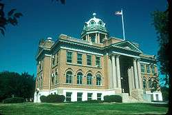 LaMoure County Courthouse in LaMoure | |
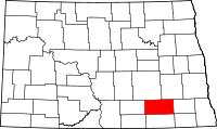 Location in the U.S. state of North Dakota | |
 North Dakota's location in the U.S. | |
| Founded | October 17, 1881 |
| Seat | LaMoure |
| Largest city | LaMoure |
| Area | |
| • Total | 1,151 sq mi (2,981 km2) |
| • Land | 1,146 sq mi (2,968 km2) |
| • Water | 4.9 sq mi (13 km2), 0.4% |
| Population (est.) | |
| • (2016) | 4,111 |
| • Density | 3.6/sq mi (1.4/km2) |
| Congressional district | At-large |
| Time zone | Central: UTC−6/−5 |
| Website |
www |
LaMoure County is a county located in the U.S. state of North Dakota. As of the 2010 census, the population was 4,139.[1] Its county seat is LaMoure.[2] The county was created in 1873 and later organized in 1881.[3][4] It was named for Judson LaMoure, a state legislator.[5]
Geography
According to the U.S. Census Bureau, the county has a total area of 1,151 square miles (2,980 km2), of which 1,146 square miles (2,970 km2) is land and 4.9 square miles (13 km2) (0.4%) is water.[6]
Adjacent counties
- Stutsman County (north)
- Barnes County (northeast)
- Ransom County (east)
- Dickey County (south)
- McIntosh County (southwest)
- Logan County (west)
National protected area
Demographics
| Historical population | |||
|---|---|---|---|
| Census | Pop. | %± | |
| 1880 | 20 | — | |
| 1890 | 3,187 | 15,835.0% | |
| 1900 | 6,048 | 89.8% | |
| 1910 | 10,724 | 77.3% | |
| 1920 | 11,564 | 7.8% | |
| 1930 | 11,517 | −0.4% | |
| 1940 | 10,298 | −10.6% | |
| 1950 | 9,498 | −7.8% | |
| 1960 | 8,705 | −8.3% | |
| 1970 | 7,117 | −18.2% | |
| 1980 | 6,473 | −9.0% | |
| 1990 | 5,383 | −16.8% | |
| 2000 | 4,701 | −12.7% | |
| 2010 | 4,139 | −12.0% | |
| Est. 2016 | 4,111 | [7] | −0.7% |
| U.S. Decennial Census[8] 1790-1960[9] 1900-1990[10] 1990-2000[11] 2010-2016[1] | |||
2000 census
As of the census of 2000, there were 4,701 people, 1,942 households, and 1,308 families residing in the county. The population density was 4 people per square mile (2/km²). There were 2,271 housing units at an average density of 2 per square mile (1/km²). The racial makeup of the county was 99.23% White, 0.02% African American, 0.17% Native American, 0.13% Asian, 0.00% Pacific Islander, 0.11% from other races, and 0.34% from two or more races. 0.55% of the population were Hispanic or Latino of any race. 50.7% were of German, 22.8% Norwegian and 5.5% Swedish ancestry.
There were 1,942 households out of which 27.50% had children under the age of 18 living with them, 60.50% were married couples living together, 4.00% had a female householder with no husband present, and 32.60% were non-families. 30.80% of all households were made up of individuals and 16.60% had someone living alone who was 65 years of age or older. The average household size was 2.38 and the average family size was 2.99.
In the county, the population was spread out with 24.20% under the age of 18, 5.40% from 18 to 24, 23.00% from 25 to 44, 24.00% from 45 to 64, and 23.40% who were 65 years of age or older. The median age was 43 years. For every 100 females there were 102.40 males. For every 100 females age 18 and over, there were 100.70 males.
The median income for a household in the county was $29,707, and the median income for a family was $36,495. Males had a median income of $26,351 versus $17,500 for females. The per capita income for the county was $17,059. 14.70% of the population and 12.30% of families were below the poverty line. Out of the total people living in poverty, 16.30% are under the age of 18 and 12.90% are 65 or older.
2010 census
As of the 2010 United States Census, there were 4,139 people, 1,825 households, and 1,182 families residing in the county.[12] The population density was 3.6 inhabitants per square mile (1.4/km2). There were 2,238 housing units at an average density of 2.0 per square mile (0.77/km2).[13] The racial makeup of the county was 98.5% white, 0.4% American Indian, 0.1% black or African American, 0.1% Asian, 0.2% from other races, and 0.6% from two or more races. Those of Hispanic or Latino origin made up 0.8% of the population.[12] In terms of ancestry, 63.0% were German, 27.6% were Norwegian, 6.2% were Swedish, 6.1% were Russian, 6.0% were English, and 2.8% were American.[14]
Of the 1,825 households, 22.8% had children under the age of 18 living with them, 56.9% were married couples living together, 4.6% had a female householder with no husband present, 35.2% were non-families, and 32.7% of all households were made up of individuals. The average household size was 2.23 and the average family size was 2.82. The median age was 49.2 years.[12]
The median income for a household in the county was $46,098 and the median income for a family was $60,932. Males had a median income of $41,250 versus $25,172 for females. The per capita income for the county was $27,056. About 6.8% of families and 9.1% of the population were below the poverty line, including 6.8% of those under age 18 and 16.9% of those age 65 or over.[15]
Transportation
Major highways


Airports
Kulm Municipal Airport (FAA LID: D03) is a public use airport located in LaMoure County, one nautical mile (1.85 km) northeast of the central business district of Kulm, North Dakota.
Communities
Cities
Unincorporated community
- Alfred
- Nortonville
Townships
- Adrian
- Badger
- Black Loam
- Bluebird
- Dean
- Gladstone
- Glen
- Glenmore
- Golden Glen
- Grand Rapids
- Grandview
- Greenville
- Henrietta
- Kennison
- Mikkelson
- Nora
- Norden
- Ovid
- Pearl Lake
- Pomona View
- Prairie
- Raney
- Ray
- Roscoe
- Russell
- Ryan
- Saratoga
- Sheridan
- Swede
- Wano
- Willowbank
Ghost town
U.S. Navy ships
The United States Navy commissioned two tank landing ships named for the county. The first, USS La Moure County (LST-883), was commissioned 23 January 1945, and served until 7 December 1959. The second, USS La Moure County (LST-1194), was commissioned December 1, 1971 and served until 17 November 2000.
Politics
| Year | Republican | Democratic | Third parties |
|---|---|---|---|
| 2016 | 68.9% 1,481 | 23.3% 502 | 7.8% 168 |
| 2012 | 62.8% 1,377 | 33.7% 740 | 3.5% 77 |
| 2008 | 58.5% 1,310 | 38.7% 868 | 2.8% 63 |
| 2004 | 68.2% 1,592 | 30.5% 712 | 1.3% 31 |
| 2000 | 64.4% 1,590 | 27.9% 689 | 7.7% 189 |
| 1996 | 51.2% 1,220 | 36.9% 880 | 12.0% 285 |
| 1992 | 46.0% 1,270 | 28.9% 797 | 25.2% 696 |
| 1988 | 56.6% 1,642 | 42.2% 1,223 | 1.2% 36 |
| 1984 | 63.6% 1,978 | 34.9% 1,086 | 1.4% 44 |
| 1980 | 64.9% 2,136 | 25.8% 850 | 9.3% 306 |
| 1976 | 49.0% 1,735 | 48.6% 1,718 | 2.4% 85 |
| 1972 | 59.6% 2,110 | 39.5% 1,399 | 0.9% 30 |
| 1968 | 57.9% 2,008 | 36.6% 1,269 | 5.5% 191 |
| 1964 | 42.7% 1,604 | 57.1% 2,145 | 0.2% 6 |
| 1960 | 61.4% 2,511 | 38.5% 1,575 | 0.1% 4 |
| 1956 | 58.9% 2,433 | 41.0% 1,694 | 0.2% 7 |
| 1952 | 73.1% 3,202 | 26.2% 1,145 | 0.7% 32 |
| 1948 | 53.9% 1,999 | 39.9% 1,481 | 6.2% 228 |
| 1944 | 61.3% 2,298 | 37.9% 1,422 | 0.9% 32 |
| 1940 | 63.7% 2,943 | 35.4% 1,637 | 0.9% 40 |
| 1936 | 33.1% 1,614 | 49.5% 2,412 | 17.4% 845 |
| 1932 | 24.7% 1,134 | 72.2% 3,310 | 3.0% 139 |
| 1928 | 55.0% 2,245 | 44.1% 1,800 | 0.9% 37 |
| 1924 | 43.2% 1,647 | 5.8% 221 | 51.0% 1,942 |
| 1920 | 77.6% 2,991 | 16.7% 645 | 5.7% 219 |
| 1916 | 47.6% 1,045 | 45.1% 990 | 7.3% 161 |
| 1912 | 28.6% 436 | 38.6% 588 | 32.8% 499 |
| 1908 | 64.8% 1,104 | 32.4% 553 | 2.8% 48 |
| 1904 | 77.1% 860 | 17.5% 195 | 5.4% 60 |
| 1900 | 58.4% 597 | 39.6% 405 | 2.0% 20 |
See also
References
- 1 2 "State & County QuickFacts". United States Census Bureau. Archived from the original on July 13, 2011. Retrieved November 1, 2013.
- ↑ "Find a County". National Association of Counties. Retrieved 2011-06-07.
- ↑ "Dakota Territory, South Dakota, and North Dakota: Individual County Chronologies". Dakota Territory Atlas of Historical County Boundaries. The Newberry Library. 2006. Retrieved February 3, 2015.
- ↑ "County History". North Dakota.gov. The State of North Dakota. Retrieved February 3, 2015.
- ↑ Gannett, Henry (1905). The Origin of Certain Place Names in the United States. Government Printing Office. p. 180.
- ↑ "2010 Census Gazetteer Files". United States Census Bureau. August 22, 2012. Archived from the original on January 29, 2015. Retrieved January 28, 2015.
- ↑ "Population and Housing Unit Estimates". Retrieved June 9, 2017.
- ↑ "U.S. Decennial Census". United States Census Bureau. Retrieved January 28, 2015.
- ↑ "Historical Census Browser". University of Virginia Library. Retrieved January 28, 2015.
- ↑ Forstall, Richard L., ed. (April 20, 1995). "Population of Counties by Decennial Census: 1900 to 1990". United States Census Bureau. Retrieved January 28, 2015.
- ↑ "Census 2000 PHC-T-4. Ranking Tables for Counties: 1990 and 2000" (PDF). United States Census Bureau. April 2, 2001. Retrieved January 28, 2015.
- 1 2 3 "DP-1 Profile of General Population and Housing Characteristics: 2010 Demographic Profile Data". United States Census Bureau. Retrieved 2016-03-14.
- ↑ "Population, Housing Units, Area, and Density: 2010 - County". United States Census Bureau. Retrieved 2016-03-14.
- ↑ "DP02 SELECTED SOCIAL CHARACTERISTICS IN THE UNITED STATES – 2006-2010 American Community Survey 5-Year Estimates". United States Census Bureau. Retrieved 2016-03-14.
- ↑ "DP03 SELECTED ECONOMIC CHARACTERISTICS – 2006-2010 American Community Survey 5-Year Estimates". United States Census Bureau. Retrieved 2016-03-14.
- ↑ Leip, David. "Dave Leip's Atlas of U.S. Presidential Elections". uselectionatlas.org. Retrieved 2018-04-12.
External links
- LaMoure County bicentennial celebration : July 2, 3, 4, 5, 1976, Memorial Park, Grand Rapids, N.D. from the *Digital Horizons website
- In the valley of the Jim (1937) from the Digital Horizons website
- [www.lamourend.com/ LaMoure County Chamber of Commerce]
Places adjacent to LaMoure County, North Dakota | ||||||||||
|---|---|---|---|---|---|---|---|---|---|---|
| ||||||||||
Municipalities and communities of LaMoure County, North Dakota, United States | ||
|---|---|---|
| Cities | | |
| Townships |
| |
| Unincorporated communities |
| |
