Absaraka, North Dakota
| Absaraka, North Dakota | |
|---|---|
| Unincorporated community | |
 Sign for Absaraka | |
 Absaraka  Absaraka | |
| Coordinates: 46°58′41″N 97°23′40″W / 46.97806°N 97.39444°WCoordinates: 46°58′41″N 97°23′40″W / 46.97806°N 97.39444°W | |
| Country | United States |
| State | North Dakota |
| County | Cass |
| Elevation | 1,070 ft (330 m) |
| Time zone | UTC-6 (Central (CST)) |
| • Summer (DST) | UTC-5 (CDT) |
| Area code(s) | 701 |
| GNIS feature ID | 1027648[1] |
Absaraka is an unincorporated community in central Cass County, North Dakota, United States. It lies northwest of the city of Fargo, the county seat of Cass County.[2] Its elevation is 1,070 feet (326 m), and it is located at 46°58′41″N 97°23′40″W / 46.97806°N 97.39444°W (46.9780313, -97.3945341).[3]
References
- ↑ "Absaraka". Geographic Names Information System. United States Geological Survey.
- ↑ Rand McNally. The Road Atlas '08. Chicago: Rand McNally, 2008, p. 77.
- ↑ Geographic Names Information System Feature Detail Report, Geographic Names Information System, 1980-02-13. Accessed 2008-03-28.
Municipalities and communities of Cass County, North Dakota, United States | ||
|---|---|---|
| Cities | 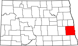 | |
| Townships | ||
| CDPs | ||
| Unincorporated communities | ||
| Footnotes | ‡This populated place also has portions in an adjacent county or counties | |
This article is issued from
Wikipedia.
The text is licensed under Creative Commons - Attribution - Sharealike.
Additional terms may apply for the media files.