Anna, Illinois
| Anna, Illinois | ||
|---|---|---|
| City | ||
| City of Anna | ||
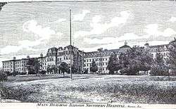 The Anna State Asylum, built in 1869 in the Kirkbride Plan was a rambling four-story structure, part of which was destroyed in separate incidents, but most of which is still standing as the central complex to the C.L. Choate Mental Health and Developmental Center. | ||
| ||
 Location of Anna in Union County, Illinois | ||
 Anna, Illinois Location of Anna in Union County, Illinois | ||
| Coordinates: 37°27′40″N 89°14′20″W / 37.46111°N 89.23889°WCoordinates: 37°27′40″N 89°14′20″W / 37.46111°N 89.23889°W | ||
| Country |
| |
| State |
| |
| County | Union | |
| Platted | March 3, 1854 | |
| Incorporated | February 16, 1865 | |
| Government | ||
| • Mayor | Steve Hartline | |
| Area[1] | ||
| • Total | 3.57 sq mi (9.25 km2) | |
| • Land | 3.55 sq mi (9.20 km2) | |
| • Water | 0.02 sq mi (0.05 km2) | |
| Elevation | 610 ft (190 m) | |
| Population (2010) | ||
| • Total | 4,442 | |
| • Estimate (2016)[2] | 4,269 | |
| • Density | 1,201.52/sq mi (463.88/km2) | |
| Time zone | UTC-6 (CST) | |
| • Summer (DST) | UTC-5 (CDT) | |
| ZIP code | 62906 | |
| Area code(s) | 618 | |
| FIPS code | 17-01543 | |
| Website |
www | |

Anna is a city in Union County, Illinois, United States. Located in Southern Illinois, the population was 4,442 at the 2010 United States Census, a decline from 5,135 in 2000. The city is known for being tied to its close neighbor Jonesboro, together known as Anna-Jonesboro. Anna is renowned for the Anna State Mental Hospital or the Choate Mental Health Care Center. It is also known for its racist acrostic, "Ain't No N*****s Allowed".[3]
History
Anna was platted on March 3, 1854.[4] The village was named after Anna Davie, the wife of a first settler.[5] The city was incorporated on February 16, 1865.[6]
Anna was historically a sundown town, in which African Americans were excluded from living in the town's limits. In 1909, a mob of angry white citizens drove out Anna's black families following the lynching in a nearby town of a black man.[7][8] According to historian James W. Loewen, a common adage in the town was that its name of "Anna" was actually an acronym, standing for "Ain't No N*****'s Allowed". However, this acronym is rarely, if ever, used by any of the current residents of the town, and several black families now live in Anna.[9][10]
Geography
Anna is located at 37°27′40″N 89°14′20″W / 37.46111°N 89.23889°W.[11]
According to the 2010 census, Anna has a total area of 3.519 square miles (9.11 km2), of which 3.5 sq mi (9.06 km2) (or 99.46%) is land and 0.019 sq mi (0.05 km2) (or 0.54%) is water.[12]
Demographics
| Historical population | |||
|---|---|---|---|
| Census | Pop. | %± | |
| 1860 | 769 | — | |
| 1870 | 1,269 | 65.0% | |
| 1880 | 1,494 | 17.7% | |
| 1890 | 2,295 | 53.6% | |
| 1900 | 2,618 | 14.1% | |
| 1910 | 2,809 | 7.3% | |
| 1920 | 3,019 | 7.5% | |
| 1930 | 3,436 | 13.8% | |
| 1940 | 4,092 | 19.1% | |
| 1950 | 4,380 | 7.0% | |
| 1960 | 4,280 | −2.3% | |
| 1970 | 4,766 | 11.4% | |
| 1980 | 5,408 | 13.5% | |
| 1990 | 4,805 | −11.2% | |
| 2000 | 5,136 | 6.9% | |
| 2010 | 4,442 | −13.5% | |
| Est. 2016 | 4,269 | [2] | −3.9% |
| U.S. Decennial Census[13] | |||
As of the census[14] of 2010, there were 4,442 people, 1,893 households and 1,097 families residing in the city. The population density was 1,269.1 people per square mile. There were 2,123 housing units at an average density of 606.6 per square mile. The racial makeup of the city was 95.7% White, 1.1% African American, 0.6% American Indian and Alaskan Native, 0.4% Asian, <0.1% Pacific Islander, 1.2% from other races, and .9% from two or more races. Hispanic or Latino people (of any race) were 2.9% of the population.
There were 1,893 households out of which 24.2% had children under the age of 18 living with them, 42.6% were married couples living together, 14.1% had a female householder with no husband present, 4.8% had a male householder with no wife present and 42.0% were non-families. 37.8% of all households were made up of individuals and 21.0% had someone living alone who was 65 years of age or older. The average household size was 2.19 and the average family size was 2.85.
In the city, the population was spread out with 22.7% aged 19 and younger, 7.0% from 20 to 24, 22.7% from 25 to 44, 24.5% from 45 to 64, and 23.0% who were 65 years of age or older. The median age was 42.8 years. For every 100 females, there were 91.7 males.
The median income for a household in the city was $39,602, the median income for a family was $44,420. The incomes of 20.2% of the population were below the poverty level.[15]
Public schools in Anna include Anna Jr High School Davie School and the Lincoln School, both part of Anna District #37 [16] and the Anna-Jonesboro Community High School District #81.[17]
Notable residents
- Delos Brown, pinch hitter for the Chicago White Sox, born in Anna
- Kenneth Buzbee, politician
- Clyde L. Choate, politician and soldier
- Townsend F. Dodd, aviator
- George M.C. Fisher, former CEO of Motorola and Kodak
- Frank E. Midkiff, High Commissioner of the Trust Territory of the Pacific, born in Anna
- King Neptune, famous war bond-raising pig
- Frank Willard, cartoonist
References
- ↑ "2016 U.S. Gazetteer Files". United States Census Bureau. Retrieved Jun 30, 2017.
- 1 2 "Population and Housing Unit Estimates". Retrieved June 9, 2017.
- ↑ Gallagher, Charles A. Race and Racism in the United States: An Encyclopedia of the American Mosaic. ABC-CLIO. p. 1208.
- ↑ Lam, Howard (1954). 100 Years of Progress: The Centennial History of Anna, Illinois. Anna, Ill: Anna Centennial Committee. OCLC 9349651.
- ↑ Illinois Central Magazine. Illinois Central Railroad Company. 1922. p. 42.
- ↑ Illinois Regional Archives Depository System. "Name Index to Illinois Local Governments". Illinois State Archives. Illinois Secretary of State. Retrieved 30 August 2013.
- ↑ Wexler, Laura. "Darkness on the Edge of Town". Washington Post. Washington Post. Retrieved 18 January 2016.
- ↑ Brown, edited by Nikki L.M.; Stentiford, Barry M. (2008). The Jim Crow Encyclopedia (1st ed.). Westport, Conn.: Greenwood Publishing Group. p. 345. ISBN 9780313341816. Retrieved 9 April 2016.
- ↑ James W. Loewen. "Sundown Towns". Retrieved 1 August 2014.
- ↑ Noah Berlatsky. "America After Dark". Retrieved 1 August 2014.
- ↑ U.S. Geological Survey Geographic Names Information System: City of Anna
- ↑ "G001 - Geographic Identifiers - 2010 Census Summary File 1". United States Census Bureau. Retrieved 25 December 2015.
- ↑ "Census of Population and Housing". Census.gov. Archived from the original on May 12, 2015. Retrieved June 4, 2015.
- ↑ "American FactFinder". United States Census Bureau. Retrieved October 3, 2015.
- ↑ "United States Census Bureau". 2009–2013.
- ↑ "Anna District 37". www.anna37.com. Retrieved 2018-04-23.
- ↑ "Anna Jonesboro Community High School". www.aj81.net. Retrieved 2018-04-23.
External links
Municipalities and communities of Union County, Illinois, United States | ||
|---|---|---|
| Cities | ||
| Villages | ||
| Precincts |
| |
| Unincorporated communities | ||
| Counties |  | |
|---|---|---|
| Mid-sized cities (25,000+) | ||
| Small Cities (10,000-25,000) | ||
| Small Cities (5,000-10,000) | ||
| Interstates | ||
| Airports/Military bases |
| |
| Universities | ||
| Colleges | ||
| Sports teams based in the Southern Illinois | ||