North Dupo, Illinois
| North Dupo, Illinois | |
|---|---|
| Unincorporated community | |
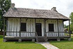 Pierre Martin House | |
 North Dupo, Illinois | |
| Coordinates: 38°32′58″N 90°12′02″W / 38.54944°N 90.20056°WCoordinates: 38°32′58″N 90°12′02″W / 38.54944°N 90.20056°W | |
| Country | United States |
| State | Illinois |
| County | St. Clair |
| Elevation | 410 ft (120 m) |
| Time zone | UTC-6 (Central (CST)) |
| • Summer (DST) | UTC-5 (CDT) |
| Area code(s) | 618 |
| GNIS feature ID | 426445[1] |
North Dupo is an unincorporated community in Sugarloaf Township, St. Clair County, Illinois, United States. North Dupo is located along Illinois Route 3 south of Cahokia and north of Dupo, bordering both villages.[2] The Pierre Martin House, which is listed on the National Register of Historic Places, is located in North Dupo.[3]
References
- ↑ "North Dupo". Geographic Names Information System. United States Geological Survey.
- ↑ St. Clair County General Highway Map (PDF) (Map). Illinois Department of Transportation. 2010. Retrieved 2011-07-19.
- ↑ National Park Service (2010-07-09). "National Register Information System". National Register of Historic Places. National Park Service.
Municipalities and communities of St. Clair County, Illinois, United States | ||
|---|---|---|
| Cities | ||
| Villages | ||
| Townships | ||
| CDPs | ||
| Other unincorporated communities | ||
| Footnotes | ‡This populated place also has portions in an adjacent county or counties | |
This article is issued from
Wikipedia.
The text is licensed under Creative Commons - Attribution - Sharealike.
Additional terms may apply for the media files.