Basti district
| Basti district | |
|---|---|
| District of Uttar Pradesh | |
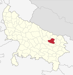 Location of Basti district in Uttar Pradesh | |
| Country | India |
| State | Uttar Pradesh |
| Administrative division | Basti |
| Headquarters | Basti, Uttar Pradesh |
| Government | |
| • Lok Sabha constituencies | Basti |
| Area | |
| • Total | 2,718 km2 (1,049 sq mi) |
| Population (2011) | |
| • Total | 2,461,056 |
| • Density | 910/km2 (2,300/sq mi) |
| Demographics | |
| • Literacy | 67.2 per cent |
| • Sex ratio | 929 |
| Major highways | National Highway 28 |
| Average annual precipitation | 1166 mm mm |
| Website | Official website |
Basti district is one of the districts of Uttar Pradesh state, India, and a part of Basti Division. Basti town is the district headquarters. In the freedom struggle of 1857, about 250 martyrs of Amorha State were hanged by the British Government from peepal trees located at Chhawani.[1][2][3][4]
Origin of name and history
Basti came from the original name basisthi, Basisth the great sage ashram situated in this area.[5] Sher Shah Suri made a well and a sarai here and hence receiving the name.
In 1801, the town Basti became a tehsil headquarter, and in 1865, it was chosen as the headquarters of the newly established Basti district of Gorakhpur Commissionary.[6]
Amorha Khas is a historical place situated at a distance of 41 km from the district headquarters. Its old name is Amorha, and it was once a province (state) of Raja Zalim Singh. Raja Zalim Singh's Mahal is here, old wall of mahal is still there with the mark of a bullet used by the English. The famous temple Ramrekha Mandir is here. Ramrekha Temple is one of the most ancient Hindu Mandir of Lord Ram and Goddess Sita. Lord Shri Ram stayed here for one day during his journey of Janakpur-Ayodhya. Lord Shri Rama and Sita with Lakshmana journeyed towards Ayodhya by the road called Ram Janki Marg (State Highway 72) near Chhawani.[2][3][4]
Geography
The district lies between the parallels of 26° 23' and 27° 30' North Latitude and 82° 17' and 83° 20' East longitude. Its maximum length from north to south is about 75 km. and breadth from east to west about 70 km. The district lies between newly created district Sant Kabir Nagar on the east and Gonda on the west on the south, the Ghaghra river near Amorha Khas previously known as Amorha Province or State of Raja Zalim Singh separates it from the Faizabad and newly created district Ambedkar Nagar. On the north it is bounded by district Sidharth Nagar.[7][8][9]
Demographics
According to the 2011 census, Basti district had a population of 2,461,056, and almost all of the population lived in rural villages,[11] This ranked it the 179th most populous district in India.[11] The district had a population density of 916 inhabitants per square kilometre (2,370/sq mi).[11] Its population growth rate over the decade 2001-2011 was 18.05%.[11] Basti had a sex ratio of 959 females for every 1000 males,[11] and a literacy rate of 69.69%.[11] The sex ratio of 959 was above both the national ratio of 940.27 and Uttar Pradesh's 908. The child sex ratio of Basti was 922, which again is above the national average of 914 female children per 1000 males.
Languages
Languages spoken in the district include Awadhi in western areas and Bhojpuri in the eastern side. The district Basti may be considered as the demarcation of the languages Awadhi and Hindi. In city, due to increase in educated population, khari boli of Hindi is also observed in daily conversations.[12]
Indian diaspora
During the late 1800s some 6,415 people from the district of Basti migrated through the indenture system to the Fiji Islands. A lot stayed and carried their traditions in the then British Colony.[13]
Education
The district follows a usual 10+2+3 pattern of education as elsewhere in India. Some notable schools and institutions of the district are :
- Kendriya Vidyalaya [14](affiliated to CBSE)
- Sarla International Academy (affiliated to CBSE)
- St. Basils School (affiliated to CISCE)[15]
- All India Institute of Information Technology[16]
- Jawahar Navodaya Vidyalaya Basti [17]
- Karma Devi Smriti Mahavidyalaya [18]
- Little Flower High School, Kalwari Basti [19][20]
- Little Flower Senior Secondary School, Harraiya Basti [21][22]
- Saraswati Vidya Mandir (affiliated to CBSE)
- Unique Science Academy[23]
Administration
.jpg)
Basti town is the district headquarters of the district.[5] Basti district, a part of Basti division, is formed of four tehsils: Basti, Harriya, Bhanpur and Rudhauli, and 15 development blocks,[24] 139 Nyay Panchayats, two Parganas named Amorha & Nagar as well as 10 Gram Sabhas. The development blocks included are:
Economy
The district is noted for its cotton textiles and sugar industries. Cottage industries and small-scale industries including the manufacturing units of brassware, iron and carpentry goods, agricultural implements, bricks, agro-products, foot-wear, soaps, candles, and pottery are present here. Basti is also known for its bamboo, eucalyptus (Eucalyptus teritrornis), mango and shisham (Dalbergia sissoo) populations. Three sugar factories are housed in the district. Sugarcane, maize, paddy, pulses, wheat, barley, and potato are commonly cultivated. The most of the population is depending for their livelihood on agricultural practices. The district is well connected through NH 28 which reflects on its good economy. The city is well connected through railways also.

In 2006 the Ministry of Panchayati Raj named Basti one of the country's 250 most backward districts (out of a total of 640).[25] It is one of the 34 districts in Uttar Pradesh currently receiving funds from the Backward Regions Grant Fund Programme (BRGF).[25] City is also known for nationwide youth organisation National Association of Youth founded by Bhavesh Kumar Pandey and run from Basti. [26] The organization organizes Basti Mini Marathon every year since 2012.
Transportation
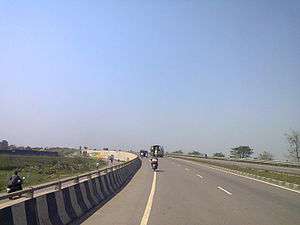
Basti railway station lies on the main line connecting Lucknow with Gorakhpur and places in Bihar and Assam in the east passes through the south of the district. The main line has 7 railway stations which are, from east to west, Munderwa,[27] Orwara, Basti, Govindnagar, Tinich, Gaur, and Babhnan within the district. There is a daily Intercity express between Gorakhpur, Basti, Gonda, and Lucknow. National Highway 28, a part of the East West Corridor project of Government of India and NHAI,[28] also passes through Basti.
Flora and fauna
The forest cover of the district has dwindled with increasing use of land for agriculture. There are areas with high prevalence of mango (Mangifera indica), mahua (Madhuca longifolia), sal (Shorea robusta), and bamboo (Bambusa arundinacea) trees. Some of the wild animals of the district are the nilgai (Boselaphus tragocamelus), antelok (Anelok cervicapra), pig (Sus scrofa), wolf (Canis lupus), jackal (Conis aureus), fox (Vulpes bengalensis), hare (Lepus ruficandatus), monkey (Macaca mulatta), wild cat (Felis bengalensis) and the porcupine (Hystric leucura). Several species of game birds are also seen, including the peafowl (Pavo cristatus), the black partridge (Frencolinus francolinus) and the gray partridge (Francalinus pondicervanus). A number of migratory water fowls visit the water bodies of the district in winter, such as the goose (Anser anser), common teal (Anas crecca), red-crested pochard (Netta rufina), white-eyed pochard (Aythya rufa) and the wigeon (Mareca penelope). The cobra (Naja naja), krait (Bungarus caeruleus), and rat-snake (Ptyas mucosus) are commonly found. The Indian crocodile or naka (Crocodylus palustris), and the ghariyal (Gavialis gangeticus) are also found in the river Ghaghra. The common fish species are rohu (Lebeo rohita), bhakur (Catla catla), nain (Cirrhina mrigala), parhin (Wallagonia attu), krunch (Labeo calbasu), and tengan (Mystus seenghala).[5]
.jpg)
Notable people
Some notable persons from the district include:
- Harish Dwivedi - BJP elected at the Indian general elections, 2014 from the Basti (Lok Sabha constituency).
- Jagdambika Pal - former chief minister of UP Government
- Sarveshwar Dayal Saxena - Hindi poet who received the government Sahitya Academy prize
- Ramchandra Shukla - regarded as the first codifier of the history of Hindi literature in a scientific system
- Obaid Siddiqi - biologist (geneticist), referred to as the founder of modern biology in India; founded TIFR (Molecular Biology Dep.) and NCB, Bangalore
- Raj Kishore Singh - former cabinet minister in UP Government
See also
References
- ↑ "Places of Interest". basti.nic.in. Retrieved 9 June 2016.
- 1 2 Thomas, D. (1998). Battles and Honours of the Royal Navy. Leo Cooper. p. 16. ISBN 9780850526233. Retrieved 2017-01-14.
- 1 2 Benett, W.C. (1878). The final settlement report on the Gonda district. 23. p. 22. Retrieved 2017-01-14.
- 1 2 Michael, B.A. (2014). Statemaking and Territory in South Asia: Lessons from the Anglo–Gorkha War (1814–1816). Anthem Press. p. 151. ISBN 9781783083220. Retrieved 2017-01-14.
- 1 2 3 "Origin of name". Basti Govt. Retrieved 13 March 2014.
- ↑ http://basti.nic.in/general%20profile/general%20profile.htm
- ↑ http://basti.nic.in/general%20profile/Geography%20of%20basti.htm
- ↑ "Yahoo maps location of Basti". Yahoo maps. Retrieved 2009-03-29.
- ↑ Thomas, David (17 December 1998). "Battles & Honours of Royal Navy". Pen and Sword. Retrieved 25 July 2016 – via Google Books.
- ↑ "Basti District Religion Census 2011". census2011.co.in. Retrieved 6 September 2018.
- 1 2 3 4 5 6 "District Census 2011". Census2011.co.in. 2011. Retrieved 2011-09-30.
- ↑ Gopeshwar Tripathi, ed. (2009). "Bhojpuri: A language of India". Ethnologue: Languages of the World (16th ed.). Dallas, Texas: SIL International. Retrieved 2011-09-30.
- ↑ http://girmit.org/?page_id=1242
- ↑ Kendriya Vidyalaya
- ↑ "Home page". Retrieved 26 July 2013.
- ↑ "AIIIT". Retrieved 14 June 2015.
- ↑ "JNV". Retrieved 3 May 2014.
- ↑ "Karma Devi Smriti Mahavidyalaya". Archived from the original on 25 February 2015. Retrieved 25 February 2015.
- ↑ "Catholic Diocese of Gorakhpur". www.dioceseofgorakhpur.org. Retrieved 2016-02-03.
- ↑ "LITTLE FLOWER H S KALWARI BASTI". upmspboard.com. Retrieved 2016-02-03.
- ↑ "Catholic Diocese of Gorakhpur". www.dioceseofgorakhpur.org. Retrieved 2016-02-03.
- ↑ "Little Flower School, Harraiya". lfsharraiya.in. Retrieved 2016-02-03.
- ↑ http://uniquescienceacademy.com/
- ↑ http://www.jagran.com/uttar-pradesh/basti-15245916.html
- 1 2 Ministry of Panchayati Raj (8 September 2009). "A Note on the Backward Regions Grant Fund Programme" (PDF). National Institute of Rural Development. Archived from the original (PDF) on 5 April 2012. Retrieved 27 September 2011.
- ↑ "NAY". Retrieved 18 Jan 2016.
- ↑ "Welcome - Munderwa". Retrieved 4 October 2014.
- ↑ "Welcome to NHAI". Archived from the original on 4 March 2016. Retrieved 25 July 2016.
External links
- Official website of Basti (U.P.) administration
- Munderwa, Basti District
- Introduction - Basti District
- Agriculture Basti
- Basti District map
- District Court of Basti
Places adjacent to Basti district | |
|---|---|