Pierre Jacotin

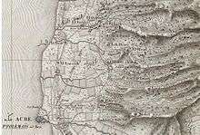
An area of Northern Palestine, 1826, by Jacotin
Pierre Jacotin (1765–1827) was named director of all the surveyors and geographers working in the Nile Valley in 1799 during the campaign in Egypt of Napoleon. Later on, he also prepared maps of Palestine during Napoleon's campaign there.
After his return from Egypt, Jacotin worked on preparing the plates for publication, but in 1808 Napoleon formally made them state secrets and forbade publication. This was apparently connected with Napoleon's efforts at the time to establish an alliance with the Ottomans.
It was not until 1817 that the engraved plates could be published.[1]
References
Bibliography
- Khatib, Hisham (2003). Palestine and Egypt Under the Ottomans: Paintings, Books, Photographs, Maps and Manuscripts. I. B. Tauris. ISBN 1-860-64888-6.
Further reference
- Kallner, D. H. (1944). "Jacotin's Map of Palestine". Quarterly statement - Palestine Exploration Fund. 76: 157–163.
- Karmon, Y. (1960). "An Analysis of Jacotin's Map of Palestine" (PDF). Israel Exploration Journal. 10 (3, 4): 155–173, 244–253.
- Panckoucke, Charles Louis Fleury (1824). Description de l'Égypte: ou, Recueil des observations et des recherches qui ont été faites en ... 17. Paris: Imprimerie de C.L.F . Panckoucke. (Pierre Jacotin: pp. 437-652, “Syria”: pp. 594-609 )
External links
- Jacotin maps at the David Rumsey Historical Map Collection .
| Authority control |
|---|
This article is issued from
Wikipedia.
The text is licensed under Creative Commons - Attribution - Sharealike.
Additional terms may apply for the media files.