Root Township, Adams County, Indiana
| Root Township | |
|---|---|
| Township | |
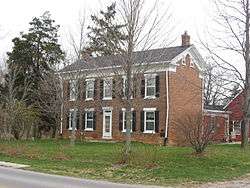 The Lenhart Farmhouse, a historic site in the township | |
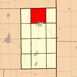 Location in Adams County | |
| Coordinates: 40°52′44″N 84°56′32″W / 40.87889°N 84.94222°WCoordinates: 40°52′44″N 84°56′32″W / 40.87889°N 84.94222°W | |
| Country | United States |
| State | Indiana |
| County | Adams |
| Government | |
| • Type | Indiana township |
| Area | |
| • Total | 35.57 sq mi (92.1 km2) |
| • Land | 35.44 sq mi (91.8 km2) |
| • Water | 0.12 sq mi (0.3 km2) 0.34% |
| Elevation | 814 ft (248 m) |
| Population (2010) | |
| • Total | 4,443 |
| • Density | 125.3/sq mi (48.4/km2) |
| ZIP code | 46733 |
| GNIS feature ID | 0453812 |
Root Township is one of twelve townships in Adams County, Indiana, United States. As of the 2010 census, its population was 4,443.[1]
Geography
According to the 2010 census, the township has a total area of 35.57 square miles (92.1 km2), of which 35.44 square miles (91.8 km2) (or 99.63%) is land and 0.12 square miles (0.31 km2) (or 0.34%) is water.[2]
Cities, towns, villages
- Decatur (north quarter)
Unincorporated towns
Adjacent townships
- Madison Township, Allen County (north)
- Monroe Township, Allen County (northeast)
- Union Township (east)
- St. Marys Township (southeast)
- Washington Township (south)
- Kirkland Township (southwest)
- Preble Township (west)
- Marion Township, Allen County (northwest)
Cemeteries
The township contains these cemeteries: Alpha, Evans Family, Kunkel Family, Monmouth, Pleasant Valley, Reynolds, St. Joseph Catholic, St. Peter Lutheran, Union Chapel Methodist and United Bretheren.
Major highways
Lakes
- Saddle Lake
Landmarks
- Hanna City Park
School districts
- North Adams Community Schools
Political districts
- Indiana's 6th congressional district
- State House District 79
- State Senate District 19
References
- "Root Township, Adams County, Indiana". Geographic Names Information System. United States Geological Survey. Retrieved 2009-09-24.
- United States Census Bureau 2007 TIGER/Line Shapefiles
- United States National Atlas
- ↑ "Geographic Identifiers: 2010 Demographic Profile Data (G001): Root township, Adams County, Indiana". U.S. Census Bureau, American Factfinder. Retrieved May 8, 2013.
- ↑ 2002 Census of Governments, Individual State Descriptions (PDF)
External links
Municipalities and communities of Adams County, Indiana, United States | ||
|---|---|---|
| Cities | ||
| Towns | ||
| Townships | ||
| Unincorporated communities |
| |
This article is issued from
Wikipedia.
The text is licensed under Creative Commons - Attribution - Sharealike.
Additional terms may apply for the media files.