Wang Sombun District
Wang Sombun (Thai: วังสมบูรณ์, pronounced [wāŋ sǒm.būːn]) is a district (amphoe) in the southwestern part of Sa Kaeo Province, eastern Thailand.
Wang Sombun วังสมบูรณ์ | |
|---|---|
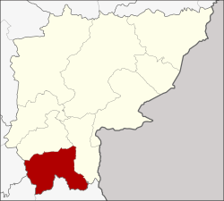 District location in Sa Kaeo Province | |
| Coordinates: 13°23′49″N 102°11′55″E | |
| Country | Thailand |
| Province | Sa Kaeo |
| Seat | Wang Mai |
| Area | |
| • Total | 383.5 km2 (148.1 sq mi) |
| Population (2005) | |
| • Total | 35,334 |
| • Density | 92.1/km2 (239/sq mi) |
| Time zone | UTC+7 (ICT) |
| Postal code | 27250 |
| Geocode | 2709 |
Geography
Neighbouring districts are (from the north clockwise) Wang Nam Yen and Khlong Hat of Sa Kaeo Province, Soi Dao and Kaeng Hang Maeo of Chanthaburi Province, and Tha Takiap of Chachoengsao Province.
History
The minor district (king amphoe) was established 1 July 1997 with three tambons split from Wang Nam Yen District.[1] On 15 May 2007, all 81 minor districts upgraded to full districts.[2] On 24 August the upgrade became official.[3]
Administration
The district is divided into three sub-districts (tambons), which are further subdivided into 48 villages (mubans). Wang Sombun is a township (thesaban tambon) which covers tambon Wang Sombun. There are a further two tambon administrative organizations (TAO).
| No. | Name | Thai name | Villages | Pop. | |
|---|---|---|---|---|---|
| 1. | Wang Sombun | วังสมบูรณ์ | 17 | 10,549 | |
| 2. | Wang Mai | วังใหม่ | 12 | 11,973 | |
| 3. | Wang Thong | วังทอง | 12 | 12,812 |
References
- ประกาศกระทรวงมหาดไทย เรื่อง แบ่งเขตท้องที่อำเภอวังน้ำเย็น จังหวัดสระแก้ว ตั้งเป็นกิ่งอำเภอวังสมบูรณ์ (PDF). Royal Gazette (in Thai). 114 (Special 51 ง): 21. June 25, 1997.
- แถลงผลการประชุม ครม. ประจำวันที่ 15 พ.ค. 2550 (in Thai). Manager Online.
- พระราชกฤษฎีกาตั้งอำเภอฆ้องชัย...และอำเภอเหล่าเสือโก้ก พ.ศ. ๒๕๕๐ (PDF). Royal Gazette (in Thai). 124 (46 ก): 14–21. August 24, 2007.