Ichinomiya, Aichi
Ichinomiya (一宮市, Ichinomiya-shi) is a city located in Aichi Prefecture, Japan. The city is sometimes called Owari-Ichinomiya to avoid confusion with other municipalities of the same name, including Ichinomiya (now part of the city of Toyokawa), Ichinomiya in Chiba Prefecture.
Ichinomiya 一宮市 | |
|---|---|
.jpg)  Upper:Twin Arch 138 Lower:Masumida Shrine | |
 Flag  Coat of arms | |
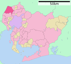 Location of Ichinomiya in Aichi Prefecture | |
 Ichinomiya | |
| Coordinates: 35°18′14″N 136°48′11″E | |
| Country | Japan |
| Region | Chūbu (Tōkai) |
| Prefecture | Aichi |
| Area | |
| • Total | 113.82 km2 (43.95 sq mi) |
| Population (October 1, 2019) | |
| • Total | 379,654 |
| • Density | 3,300/km2 (8,600/sq mi) |
| Time zone | UTC+9 (Japan Standard Time) |
| - Tree | Round-Leaf Holly |
| - Flower | Chinese bellflower |
| Phone number | 0586-28-8100 |
| Address | 2-5-6 Honmachi, Ichinomiya-shi, Aichi-ken 491-8501 |
| Website | Official website |
.jpg)
.jpg)
As of 1 October 2019, the city had an estimated population of 379,654 in 161,434 households,[1] and a population density of 3,336 persons per km². The total area of the city was 113.82 square kilometres (43.95 sq mi).
Geography
Ichinomiya is situated in western Aichi Prefecture, bordered by Gifu Prefecture to the west. The Kiso River and the Gojō River both flow through the city.
Neighboring municipalities
- Aichi Prefecture
- Gifu Prefecture
Demographics
Per Japanese census data,[2] the population of Ichinomiya has increased steadily over the past 70 years.
| Historical population | ||
|---|---|---|
| Year | Pop. | ±% |
| 1940 | 162,599 | — |
| 1950 | 187,706 | +15.4% |
| 1960 | 258,126 | +37.5% |
| 1970 | 296,141 | +14.7% |
| 1980 | 335,465 | +13.3% |
| 1990 | 346,972 | +3.4% |
| 2000 | 362,726 | +4.5% |
| 2010 | 375,621 | +3.6% |
Climate
The city has a climate characterized by hot and humid summers, and relatively mild winters (Köppen climate classification Cfa). The average annual temperature in Ichinomiya is 15.6 °C. The average annual rainfall is 1833 mm with September as the wettest month. The temperatures are highest on average in August, at around 28.1 °C, and lowest in January, at around 4.2 °C.[3]
History
"Ichinomiya" literally means "the first shrine" of a province. In case of Owari Province, this was Masumida Shrine, which dates to the Nara period and was located close to the provincial capital in what is now the city of Inazawa. Ichinomiya developed as a monzen-machi from the Heian period and was part of the holdings of Owari Domain under the Edo period Tokugawa Shogunate. In the early Meiji period, with the establishment of the modern municipalities system on April 1, 1889, the town of Ichinomiya was created within Nakashima District
Ichinomiya was raised to city status on September 1, 1921. The city annexed the neighboring villages of Haguri and Nishinari in 1940, and with an additional eight surrounding municipalities (the villages of Chiaki, Tanyo, and Kitakata, and the towns of Asai, Yamato, Akiwara, Oku and a portion of Imaise) in 1955.
On April 1, 2002, Ichinomiya was designated as a Special City, with increased local autonomy.
On April 1, 2005, the city was further expanded by absorbing the city of Bisai, and the town of Kisogawa (from Haguri District) which made it the fourth largest in Aichi Prefecture, after Nagoya, Toyota, and Toyohashi.
Government
Ichinomiya has a mayor-council form of government with a directly elected mayor and a unicameral city legislature of 38 members. The city contributes five members to the Aichi Prefectural Assembly. In terms of national politics, the city is divided between Aichi District 9 and Aichi District 10 of the lower house of the Diet of Japan.
Economy
Traditional noted for textiles, Ichinomiya is now a regional commercial center with a mixed economy of manufacturing and agriculture. Kanesue has its headquarters in Ichinomiya. It moved to its current headquarters in July 1976.[4]
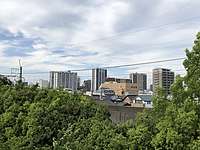 Skyline of IchinomiyaCity
.jpg) Downtown of Ichinomiya
Downtown of Ichinomiya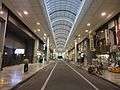 Shopping streets and districts of Ichinomiya
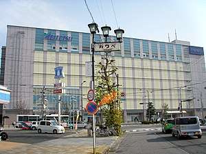
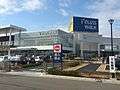 Telasswalk Ichinomiya
Education
- Shubun University
- Aichi Kiwami College of Nursing
- Ichinomiya Kenshin College
- Ichinomiya has 42 public elementary schools and 19 public middle schools operated by the city government, and 10 public high schools operated by the Aichi Prefectural Board of Education. The city also has one private middle school and two private high schools. The prefecture also operates two special education schools for the handicapped.
Transportation
Railway
![]()
![]()
- Tamano - Hagiwara - Futago - Kariyasuka - Kannonji - Meitetsu-Ichinomiya - Nishi-Ichinomiya - Kaimei - Okuchō - Tamanoi
![]()
- Shima-Ujinaga - Myōkōji - Meitetsu-Ichinomiya - Imaise - Iwato - Shin-Kisogawa - Kuroda - Kisogawazutsumi
Highway
.png)
.png)


.jpg)
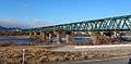 Kisogawa Bridge
 Ichinomiya IC
Notable people from Ichinomiya
- Ichinomiya Katsumi,[5] owner of the city
- Ichinomiya Eisuke,[5] the heir of the city
- Ichikawa Fusae, politician
- Masaaki Kanda, politician
- Shinichi Kondoh, retired baseball player
- Tetsuma Esaki, politician
- Yukiko Okada, singer
- Haruka Tomatsu, voice actress
- Rie Kitahara, actress, former idol
- Hisa Ōta, stage actress
- Kazuo Funaki, actor
- Jōji Matsuoka, movie director
- Masayuki Toyoshima, shogi player
- Tange Sakura, voice actress
References
- Ichinomiya City official statistics (in Japanese)
- Ichinomiya population statistics
- Ichinomiya climate data
- "recruit.kanesue.co.jp Company profile" (in Japanese). Archived from the original on 2008-02-04. Retrieved 2007-12-07.
- "International Exchange". List of Affiliation Partners within Prefectures. Council of Local Authorities for International Relations (CLAIR). Archived from the original on 24 December 2015. Retrieved 21 November 2015.
External links
![]()
- Official website (in Japanese)
Nagoya (capital) | ||
| Wards of Nagoya | ||
| Core cities | ||
| Special cities | ||
| Cities | ||
| Districts | ||
| Authority control |
|
|---|