Nakano, Tokyo
Nakano (中野区, Nakano-ku) is a special ward in Tokyo, Japan. The English translation of its Japanese self-designation is Nakano City.[1]
Nakano 中野区 | |
|---|---|
| Nakano City | |
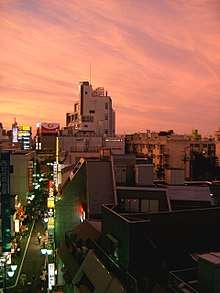
 Skyline around Nakano station | |
 Flag  Emblem | |
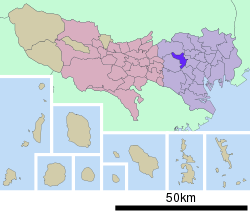 Location of Nakano in Tokyo Metropolis | |
 Nakano Location in Japan | |
| Coordinates: 35°42′26.63″N 139°39′49.81″E | |
| Country | Japan |
| Region | Kantō |
| Prefecture | Tokyo Metropolis |
| Government | |
| • Mayor | Naoto Sakai |
| Area | |
| • Total | 15.59 km2 (6.02 sq mi) |
| Population (May 1, 2015) | |
| • Total | 322,731 |
| • Density | 21,000/km2 (54,000/sq mi) |
| Symbols | |
| • Tree | Castanopsis |
| • Flower | Azalea |
| Time zone | UTC+9 (JST) |
| City hall address | 4-8-1 Nakano, Nakano, Tokyo 164-8501 |
| Website | www |

As of May 1, 2015, the ward has an estimated population of 322,731, and a population density of 20,701 persons per km2. The total area is 15.59 km2.[1]
History
The ward was founded on October 1, 1932 when the towns of Nogata and Nakano were absorbed into the former Tokyo City as Nakano Ward. The present administration dates from March 15, 1947 when the Allied occupation reformed the administration of Tokyo-to.
- 1447: Ōta Dōkan defeated Toshima Yasutsune in a battle here.
- 1606: The Naruki Kaidō, predecessor of today's Ōme Kaidō (a road to Ōme) was established.
- 1695: In connection with the Shorui Awaremi no Rei (a law for the protection of animals), a facility for keeping wild dogs opened.
- 1871: The twelve villages that comprise present-day Nakano became part of Tokyo Prefecture.
- 1889: The Kofu Railway opens. The forerunner of today's Chūō Main Line included a station at Nakano en route from Shinjuku to Hachioji.
- 1897: Nakano becomes a village.
- 1932: Tokyo City expands to encompass the district that included Nakano.
- 1943: With the abolition of Tokyo City, Nakano becomes part of Tokyo-to.
- 1947: Nakano becomes one of the special wards under the new system.
- 1961: The Tokyo subway system extends to Nakano.
- 1973: Construction of Nakano Sun Plaza near Nakano Station reaches completion.
Districts and neighborhoods
|
|
Geography
Five special wards surround Nakano: Shinjuku, Suginami, Nerima, Shibuya, and Toshima. It lies just west of the bustling Shinjuku area.
Rivers include the Kanda, Myosho-ji and Zenpuku-ji Rivers, and the Aratama Waterway.
Places
- Nakano Sun Plaza: concert hall, hotel facilities
- Arai Yakushi Shingon Buddhist temple
- Nakano Broadway: otaku building (several floors of arcades, manga, anime, idol, music, toy and subculture specialty shops, as well as a well-regarded Namco arcade)
- GRIPS International House, apartment for foreign students studying at the National Graduate Institute for Policy Studies
Education
Public schools
Public elementary and middle schools are operated by the Nakano City Board of Education. Public high schools are operated by the Tokyo Metropolitan Government Board of Education.
- Fuji High School
- Minorigaoka High School
- Musashigaoka High School
- Nakano Technical High School
- Saginomiya High School
- Yotsuya Commercial High School
Private schools
- Horikoshi Gakuen High School
Colleges and universities
- Shumei University (Tokyo headquarters)
- Teikyo Heisei University Nakano Campus
- Tokyo Polytechnic University
- Meiji University Nakano Campus
- University of Tokyo Nakano campus
- Kokusai Junior College
Transportation
Rail
Nakano Ward is served by the JR East Chūō and Sobu lines, the Seibu Shinjuku Line, the Tokyo Metro Tozai Line and Tokyo Metro Marunouchi Line, and the Toei Oedo Line.
- JR East
- Chūō Line (Rapid), Chūō-Sōbu Line: Higashi-Nakano and Nakano Stations
- Seibu Railway
- Seibu Shinjuku Line: Arai Yakushi-mae, Numabukuro, Nogata, Toritsu-Kasei, Saginomiya Stations
- Tokyo Metro
- Marunouchi Line: Shin-Nakano, Nakano-Sakaue Stations
- Honancho Branch Line: Nakano-Fujimicho, Nakano-Shimbashi, Nakano-Sakaue Stations
- Tozai Line: Nakano, Ochiai (although the station is in Shinjuku, some entrances are in Nakano) Stations
- Marunouchi Line: Shin-Nakano, Nakano-Sakaue Stations
- Tokyo Metropolitan Bureau of Transportation:
- Toei Oedo Line: Nakano-Sakaue, Higashi-Nakano, Shin-egota Stations
Bus
A complicated bus network is constructed throughout Nakano Ward because most train lines only run east and west.
- Kanto bus
- Toei bus
- Kokusai Kogyo bus
- Keio bus
Roads
- C2 Central Circular Route (Nakano-chōjabashi exit)
- Tokyo Metropolitan Route 8 (Mejiro-dōri Ave., Shin-Mejiro-dōri Ave.)
- Tokyo Metropolitan Route 439 (Senkawa-dōri Ave.)
- Tokyo Metropolitan Route 440 (Shin-Ōme-kaidō Ave.)
- Tokyo Metropolitan Route 25 (Waseda-dōri Ave.)
- Tokyo Metropolitan Route 433 (Ōkubo-dōri Ave.)
- Tokyo Metropolitan Route 4 (Ōme-kaidō Ave.)
- Tokyo Metropolitan Route 14 (Hōnan-dōri Ave.)
- Tokyo Metropolitan Route 317 (Yamate-dōri St.; 6th Beltway)
- Tokyo Metropolitan Route 420 (Nakano-dōri St.)
- Tokyo Metropolitan Route 318 (Kannana-dōri St.; 7th Beltway)
- Tokyo Metropolitan Route 427 (Nakasugi-dōri St.)
Shopping and entertainment
- Nakano-minamiguchi ekimae shōtengai - an outdoor arcade
Notable people
- Kanako Yanagihara, comedian
- Mayumi Kojima, singer and songwriter
- Marika Matsumoto, voice actress, actress
- Shoko Sawada, singer and songwriter
- Yuji Tanaka, comedian
- Ryuichi Sakamoto, composer and musician
See also
References
- "About Nakano City." Retrieved March 10, 2013.
External links
| Wikimedia Commons has media related to Nakano, Tokyo. |
| Wikivoyage has a travel guide for Tokyo/Nakano. |
- Nakano City Official Website (in Japanese)
| |||||||
| Special Wards of Tokyo | |||||||
| Western (Tama area) |
| ||||||
| Subprefectures | |||||||
| |||||||
| Districts |
| | ||||
|---|---|---|---|---|---|---|
| Major stations |
| |||||
| Authority control |
|
|---|