Nagakute, Aichi
Nagakute (長久手市, Nagakute-shi) is a city located in Aichi Prefecture, Japan. As of 1 October 2019, the city had an estimated population of 61,503 in 24,352 households,[1] and a population density of 2,854 persons per km². The total area of the city is 21.55 square kilometres (8.32 sq mi). Nagakute is a member of the World Health Organization’s Alliance for Healthy Cities (AFHC).[2]
Nagakute 長久手市 | |
|---|---|
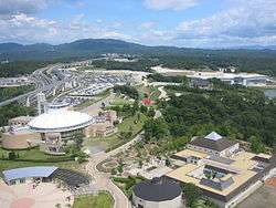 Site of Expo 2005 | |
 Flag  Seal | |
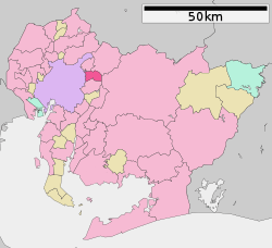 Location of Nagakute in Aichi Prefecture | |
 Nagakute | |
| Coordinates: 35°11′2.4″N 137°02′55.3″E | |
| Country | Japan |
| Region | Chūbu (Tōkai) |
| Prefecture | Aichi |
| Government | |
| • Mayor | Ippei Yoshida |
| Area | |
| • Total | 21.55 km2 (8.32 sq mi) |
| Population (October 1, 2019) | |
| • Total | 61,503 |
| • Density | 2,900/km2 (7,400/sq mi) |
| Time zone | UTC+9 (Japan Standard Time) |
| - Tree | Maple |
| - Flower | Satsuki azalea |
| Phone number | 0561-63-1111 |
| Address | 60-1 Yazako, Shironouchi, Nagakute-shi, Aichi, Japan 480-1196 |
| Website | Official website |
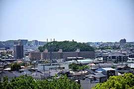
Geography
Nagakute is located in the Owari Hills of central Aichi Prefecture, at an elevation of 43 to 184 meters, and is bordered by the metropolis of Nagoya to the west. Thirteen rivers flow through the city.
Neighboring municipalities
- Nagoya (Moriyama-ku, Meitō-ku)
- Toyota
- Seto
- Nisshin
- Owariasahi
Demographics
Per Japanese census data,[3] the population of Nagakute has increased dramatically over the past 50 years.
| Historical population | ||
|---|---|---|
| Year | Pop. | ±% |
| 1940 | 5,138 | — |
| 1950 | 6,638 | +29.2% |
| 1960 | 6,639 | +0.0% |
| 1970 | 11,317 | +70.5% |
| 1980 | 18,610 | +64.4% |
| 1990 | 33,714 | +81.2% |
| 2000 | 43,306 | +28.5% |
| 2010 | 52,399 | +21.0% |
Climate
The city has a climate characterized by hot and humid summers, and relatively mild winters (Köppen climate classification Cfa). The average annual temperature in Nagakute is 15.5 °C. The average annual rainfall is 1641 mm with September as the wettest month. The temperatures are highest on average in August, at around 27.9 °C, and lowest in January, at around 4.0 °C.[4]
History
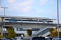
During the Sengoku period, the Battle of Komaki and Nagakute was held in this vicinity. During the Edo period area of modern Nagakute was part of the holdings of Owari Domain. Nagakute Village was established within Aichi District on May 10, 1906 through the merger of the hamlets of Nagakute (different spelling as 長湫村), Kamigō and Yazako. Nagakute was elevated to town status on April 1, 1971. Expo 2005 was a major boost to the local economy, and led to the construction of the Linimo, a commercial linear motor train, to connect the area with the Nagoya metropolis. Nagakute was elevated to city status on January 4, 2012.
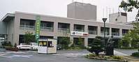
Government
Nagakute has a mayor-council form of government with a directly elected mayor and a unicameral city legislature of 18 members. The city contributes one member to the Aichi Prefectural Assembly. In terms of national politics, the city is part of Aichi District 7 of the lower house of the Diet of Japan.
Economy
Due to its location, Nagakute's economy is centered around the automobile industry. Toyota Central R&D Labs., Inc. is located in the city, as is electrical systems manufacturer Nitto Kogyo. Nagakute is also the head office of the Aichi Rapid Transit Co., Ltd., better known as the manufacturer of the Linimo Maglev High Speed Surface Transport.
Education
Higher education
- Aichi Prefectural University
- Aichi Prefectural University of Fine Arts and Music
- Aichi Medical University
- Aichi Shukutoku University
Primary education
- Nagakuta has six public elementary schools and three public junior high schools operated by the city government, and one public high school operated by the Aichi Prefectural Board of Education. There is also one private high school.
International Schools
Transportation
Railway

Highway
- The Tōmei Expressway passes through Nagakute, but there is no interchange within city limits, and the city is not served by any national highways.
Local attractions
- Toyota Automobile Museum
- Meito Art Museum
- Expo 2005 Site
- Site of the Battle of Komaki and Nagakute
- Proposed future site of Studio Ghibli amusement park, set to open by 2022
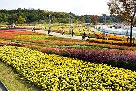 Site of Expo 2005
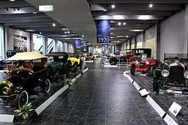 Toyota Automobile Museum
 Iroganeyama Historical park
Notable people from Nagakute
- Shinta Fukushima, professional soccer player
- Mine Kawakami, pianist
References
- Nagakute City official statistics (in Japanese)
- Alliance for Healthy Cities official home page
- Nagakute population statistics
- Nagakute climate data
- "International Exchange". List of Affiliation Partners within Prefectures. Council of Local Authorities for International Relations (CLAIR). Archived from the original on 24 December 2015. Retrieved 21 November 2015.
External links
![]()
- Official website (in Japanese)
Nagoya (capital) | ||
| Wards of Nagoya | ||
| Core cities | ||
| Special cities | ||
| Cities | ||
| Districts | ||