Seto, Aichi
Seto (瀬戸市, Seto-shi) is a city located in Aichi Prefecture, Japan. As of 1 October 2019, the city had an estimated population of 127,659 in 56,573 households,[1] and a population density of 1,146 persons per km². The total area was 111.40 square kilometres (43.01 sq mi).
Seto 瀬戸市 | |
|---|---|
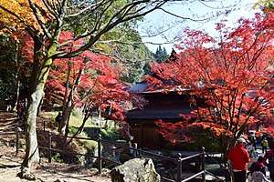 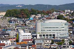 Upper stage:Jōkō-ji temple in Seto Lower stage:Seto Skyline | |
 Flag  Seal | |
 Location of Seto in Aichi Prefecture | |
 Seto | |
| Coordinates: 35°13′24.9″N 137°05′3.1″E | |
| Country | Japan |
| Region | Chūbu (Tōkai) |
| Prefecture | Aichi |
| Government | |
| • Mayor | Yasunori Ito |
| Area | |
| • Total | 111.40 km2 (43.01 sq mi) |
| Population (October 1, 2019) | |
| • Total | 127,659 |
| • Density | 1,100/km2 (3,000/sq mi) |
| Time zone | UTC+9 (Japan Standard Time) |
| Official tree | Ilex rotunda |
| Official flower | Camellia |
| Phone number | 0561-82-7111 |
| Address | 64-1 Oiwake-chō, Seto-shi, Aichi-ken 489-8701 |
| Website | Official website |
Geography
Seto is located in the hilly northern region of Aichi Prefecture, bordering Gifu Prefecture, approximately 35 minutes from Nagoya by way of the Meitetsu Seto Line. In English, the name of "Seto" translates to "the place where the river runs quickly." However, while there is a river in Seto, it is neither significantly large nor quick-moving. The city of Seto is famous for its pottery and ceramics, so much so that the generic word for ceramics in Japanese is setomono (瀬戸物). The main street along the river is lined with dozens of pottery shops. Every third Saturday and Sunday in September, there is a very large pottery festival called Setomono Matsuri [2](瀬戸物祭り) This festival attracts about 20,000 visitors from around Japan and abroad every year.
Demographics
Per Japanese census data,[3] the population of Seto has been increasing over the pas 60 years.
| Historical population | ||
|---|---|---|
| Year | Pop. | ±% |
| 1940 | 64,793 | — |
| 1950 | 68,415 | +5.6% |
| 1960 | 82,101 | +20.0% |
| 1970 | 92,681 | +12.9% |
| 1980 | 120,774 | +30.3% |
| 1990 | 126,340 | +4.6% |
| 2000 | 131,650 | +4.2% |
| 2010 | 132,240 | +0.4% |
Climate
The city has a climate characterized by hot and humid summers, and relatively mild winters (Köppen climate classification Cfa). The average annual temperature in Seto is 14.8 °C. The average annual rainfall is 1810 mm with September as the wettest month. The temperatures are highest on average in August, at around 27.3 °C, and lowest in January, at around 3.1 °C.[4]
History
During the Edo period, the area of modern Seto was controlled by the Owari Tokugawa of Owari Domain. The area had been famous for its ceramics production since at least the Kamakura period. During the Meiji period, Seto village was organized in 1888 with the establishment of the modern municipalities system, becoming a town in 1892. After annexing the neighboring village of Akatsu in 1925, Seto was raised to city status on October 1, 1929. Much of the city was destroyed by air raids in 1945 during World War II.[5]
In the postwar period, the city grew as a bedroom community for Nagoya and as a tourist designation. On March 25, 2005, Expo 2005 opened with its main site being in Nagakute and additional activity in Seto. The expo continued until September 25, 2005.
Government

Seto has a mayor-council form of government with a directly elected mayor and a unicameral city legislature of 26 members. The city contributes two members to the Aichi Prefectural Assembly. In terms of national politics, the city is part of Aichi District 6 of the lower house of the Diet of Japan.
Economy
The economy of Seto remains dominated by ceramics, both for traditional works for private consumption, and also modern industrial ceramics for the electronics industry.
Education
- Universities and colleges
- Nagoya Gakuin University – Seto campus
- Primary and secondary education
Seto has 20 public elementary schools and eight public junior high schools operated by the city government, and one private junior high school. The city has four public high schools operated by the Aichi Prefectural Board of Education. and two private high schools. The city operates one and the prefecture operates two special education schools for the handicapped.
- International School
The Aichi Korean 7th Elementary School (愛知朝鮮第七初級学校) - North Korean school[6] is located in Seto
Transportation

Highways
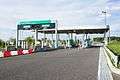 Seto-Akazu Interchange
.jpg)
Sister city relations
Local attractions
- Aichi Prefectural Ceramic Museum
- Setogura Museum
- Jōkō-ji, Buddhist temple and mausoleum of Tokugawa Yoshinao of the Owari Domain.
 Aichi Prefectural Ceramic Museum
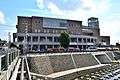 Setogura Museum
 Setomono Festival
 Unkō-ji
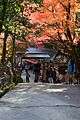 Jōkō-ji
 Kamagaki no Komichi
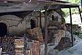 Hongyō kiln
Notable people from Seto
- Sayaka Aoki, comedian
- Junji Suzuki, politician
- Asaka Seto, actress
- Manpei Takagi, actor
- Toru Hasegawa,– professional soccer player
- Hayata Ito, professional baseball player
- Sōta Fujii, professional shogi player
References
- Seto City official statistics (in Japanese)
- Seto homestay programme
- Seto population statistics
- Seto climate data
- "瀬戸市". www.city.seto.aichi.jp.
- Home page. Aichi Korean 7th Elementary School. Retrieved on October 14, 2015. "愛知県瀬戸市にある在日コリアン児童が通う民族学校です"
- "International Exchange". List of Affiliation Partners within Prefectures. Council of Local Authorities for International Relations (CLAIR). Archived from the original on 24 December 2015. Retrieved 21 November 2015.
External links
| Wikimedia Commons has media related to Seto, Aichi. |

- Official website (in Japanese)
Nagoya (capital) | ||
| Wards of Nagoya | ||
| Core cities | ||
| Special cities | ||
| Cities | ||
| Districts | ||
| Authority control |
|
|---|