Akita (city)
Akita (秋田市, Akita-shi, Japanese: [aꜜki̥ta]) is the capital city of Akita Prefecture, Japan, and has been designated a core city since 1 April 1997. As of 1 January 2020, the city has an estimated population of 305,625, 136,628 households [1] and a population density of 340 persons per km². The total area of the city is 906.07 square kilometres (349.84 sq mi).
Akita 秋田市 | |
|---|---|
 Mount Taihei, Kubota Castle, Akita-Araya Wind Farm, Hitotsumori Park, Akita Skydome, Akita Museum of Art, Akita Akarengakan Museum, Akita City Gymnasium | |
 Flag  Seal | |
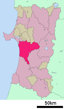 Location of Akita in Akita Prefecture | |
 Akita | |
| Coordinates: 39°43′12.1″N 140°6′9.3″E | |
| Country | Japan |
| Region | Tōhoku |
| Prefecture | Akita |
| Government | |
| • Mayor | Motomu Hozumi |
| Area | |
| • Total | 906.07 km2 (349.84 sq mi) |
| Population (January 1, 2020) | |
| • Total | 305,625 |
| • Density | 340/km2 (870/sq mi) |
| Time zone | UTC+9 (Japan Standard Time) |
| - Tree | Zelkova serrata |
| - Flower | Satsuki azalea |
| Phone number | 018-863-2222 |
| Address | 1-1 Sanno 1-chome, Akita-shi 010-8560 |
| Website | Official website |
History
The area of present-day Akita was part of ancient Dewa Province, and has been inhabited for thousands of years. The Jizōden ruins within the city limits are a major archaeological site with artifacts from the Japanese Paleolithic period through the Jōmon and Yayoi periods. During the Nara period, the Yamato court established Akita Castle in 733 AD to bring the local Emishi tribes under its control. The area was ruled by a succession of local samurai clans in the Sengoku period, before coming under the control of the Satake clan of Kubota Domain during the Edo period. Under the Tokugawa shogunate, a castle town developed around Kubota Castle.
Meiji and Taishō Eras
With the start of the Meiji period, Kubota Domain was abolished, and its castle town divided into the towns of Akita and Kubota. Akita Prefecture was established in 1871, and Shima Yoshitake was named the first governor. Ancient Akita District was divided into Kitaakita and Minamiakita Districts in 1878. Most of Akita town burned down in a great fire on 30 April 1886.
With the establishment of the modern municipalities system on 1 April 1889, the city of Akita was officially established, including former Kubota and Akita towns. The port area was separated into Tsuchizakiko Town, which became part of Minamiakita District. The first city hall was located inside the former Minamiakita District office. In September 1898, the Imperial Japanese Army’s 17th Infantry Regiment was based in Akita. The first public library was opened in 1898, electrification of the city began in 1901, and Akita Station was opened in 1902, as well as running water and telephone services in 1907.
The Taishō period brought further development to Akita with Nippon Oil Corporation developing the nearby Kurokawa Oil Fields in 1914, and a branch of the Bank of Japan opening in Akita in 1917.
Shōwa Era
In 1935, Nippon Kogyo (the forerunner of Jomo) began development of the nearby Yabase Oil Fields. Akita Bank was established in 1941.
War devastated the city on 14 August 1945. During the Tsuchizaki air raid, over 250 people were killed when 134 USAAF B-29 Superfortress, attacked the city from midnight to the early dawn. A Nippon Oil oil refinery in the Tsuchizaki area was targeted.
During the post-war period, the 16th National Sports Festival of Japan was held in Akita in 1961. During the tsunami following the 1983 Sea of Japan earthquake, three Akita residents were killed.
Heisei Era

On 1 April 1997, Akita was designated as a core city with increased autonomy. The Akita Shinkansen began operations the same year. In August 2001, the World Games were held in Akita, with the opening ceremony held in the Yabase Track and Field Stadium. In 2004, the city celebrated its 400th anniversary and its beginnings as Kubota Castle town.
On 11 January 2005, the towns of Kawabe and Yūwa (both from Kawabe District) were merged into Akita. Kawabe District was dissolved as a result of this merger. The location of Akita City Hall did not change, and former Kawabe and Yūwa Town Halls are used as civic centers. The 62nd National Sports Festival of Japan was held in Akita in 2007.
Reiwa Era
Geography
The city of Akita is located in the coastal plains of central Akita Prefecture, bordered by the Sea of Japan to the west. The Omono River runs through the center of the city.
Neighboring municipalities
- Akita Prefecture
- Kitaakita
- Katagami
- Yurihonjō
- Daisen
- Minamiakita District: Gojōme, Ikawa
- Kitaakita District: Kamikoani
- Senboku District: Nishiki
Demographics
Per Japanese census data,[2] the population of Akita peaked in around the year 2000 and has been in decline since then.
| Historical population | ||
|---|---|---|
| Year | Pop. | ±% |
| 1950 | 200,525 | — |
| 1960 | 229,933 | +14.7% |
| 1970 | 257,532 | +12.0% |
| 1980 | 304,823 | +18.4% |
| 1990 | 322,698 | +5.9% |
| 2000 | 336,646 | +4.3% |
| 2010 | 323,363 | −3.9% |
Climate
Akita belongs to a climatic transition zone humid subtropical climate (Köppen Cfa) and is the most populous city having absolute northern extremity of this climate zone within Japan, bordering very closely with the humid continental climate (Köppen Dfa) zone, comparable to New York City, USA. Akita is characterized with cold, very snowy, winters, and very warm, humid summers. Monthly averages range from 0.1 °C (32.2 °F) in January to 24.9 °C (76.8 °F) in August. Due to its location near the Sea of Japan coast, it receives heavy snowfall, with just above 377 centimetres (148 in) per season, with accumulation occurring mostly from December to March. Precipitation is well-distributed and significant throughout the year, but is greater in the latter half. Over two thirds of all days see some precipitation, either rain or snow.
| Climate data for Akita, Akita (1981-2010) | |||||||||||||
|---|---|---|---|---|---|---|---|---|---|---|---|---|---|
| Month | Jan | Feb | Mar | Apr | May | Jun | Jul | Aug | Sep | Oct | Nov | Dec | Year |
| Record high °C (°F) | 13.7 (56.7) |
19.8 (67.6) |
21.0 (69.8) |
28.0 (82.4) |
31.8 (89.2) |
33.7 (92.7) |
37.9 (100.2) |
38.2 (100.8) |
36.1 (97.0) |
28.9 (84.0) |
23.3 (73.9) |
21.4 (70.5) |
38.2 (100.8) |
| Average high °C (°F) | 2.8 (37.0) |
3.5 (38.3) |
7.4 (45.3) |
14.0 (57.2) |
19.0 (66.2) |
23.2 (73.8) |
26.5 (79.7) |
29.0 (84.2) |
24.7 (76.5) |
18.6 (65.5) |
11.9 (53.4) |
5.9 (42.6) |
15.5 (59.9) |
| Daily mean °C (°F) | 0.1 (32.2) |
0.5 (32.9) |
3.6 (38.5) |
9.6 (49.3) |
14.6 (58.3) |
19.2 (66.6) |
22.9 (73.2) |
24.9 (76.8) |
20.4 (68.7) |
14.0 (57.2) |
7.9 (46.2) |
2.9 (37.2) |
11.7 (53.1) |
| Average low °C (°F) | −2.5 (27.5) |
−2.3 (27.9) |
−0.1 (31.8) |
5.1 (41.2) |
10.5 (50.9) |
15.5 (59.9) |
19.8 (67.6) |
21.3 (70.3) |
16.5 (61.7) |
9.8 (49.6) |
4.1 (39.4) |
0.0 (32.0) |
8.2 (46.8) |
| Record low °C (°F) | −19.8 (−3.6) |
−24.6 (−12.3) |
−19.5 (−3.1) |
−7.2 (19.0) |
−1.4 (29.5) |
4.1 (39.4) |
8.9 (48.0) |
9.0 (48.2) |
3.1 (37.6) |
−1.4 (29.5) |
−5.4 (22.3) |
−18.7 (−1.7) |
−24.6 (−12.3) |
| Average precipitation mm (inches) | 119.2 (4.69) |
89.1 (3.51) |
96.5 (3.80) |
112.8 (4.44) |
122.8 (4.83) |
117.7 (4.63) |
188.2 (7.41) |
176.9 (6.96) |
160.3 (6.31) |
157.2 (6.19) |
185.8 (7.31) |
160.1 (6.30) |
1,686.2 (66.39) |
| Average snowfall cm (inches) | 138 (54) |
108 (43) |
43 (17) |
1 (0.4) |
0 (0) |
0 (0) |
0 (0) |
0 (0) |
0 (0) |
0 (0) |
11 (4.3) |
74 (29) |
377 (148) |
| Average precipitation days (≥ 0.5 mm) | 24.0 | 20.0 | 17.5 | 13.2 | 12.5 | 11.2 | 13.6 | 11.0 | 13.6 | 15.6 | 19.8 | 23.6 | 195.6 |
| Average snowy days | 27.8 | 23.6 | 17.0 | 2.2 | 0 | 0 | 0 | 0 | 0 | 0.1 | 7.0 | 21.1 | 98.8 |
| Average relative humidity (%) | 73 | 71 | 67 | 67 | 72 | 75 | 79 | 76 | 75 | 72 | 72 | 73 | 73 |
| Mean monthly sunshine hours | 39.9 | 62.5 | 124.7 | 170.4 | 182.0 | 176.2 | 150.3 | 193.0 | 153.8 | 145.4 | 82.7 | 45.1 | 1,526 |
| Source 1: Japan Meteorological Agency | |||||||||||||
| Source 2: 観測史上1~10位の値(年間を通じての値) | |||||||||||||
Government
Akita has a directly elected mayor and a unicameral city assembly with 39 members. The city contributes 12 members to the Akita Prefectural Assembly. In terms of national politics, the city is part of Akita District 1 of the lower house of the Diet of Japan.
Economy
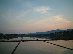
The economy of Akita remains heavily dependent on agriculture (particularly rice cultivation), forestry and mineral extraction. Akita contains one of the most important oil fields in Japan. Oil refining, woodworking, metalworking, and the production of silk textiles are the main industries. Akita is also home to two regional banks that serve Akita prefecture and the greater Tōhoku region: Akita Bank and Hokuto Bank.
The Akita Thermal Power Station is located in the city.
Education
Universities
Primary and secondary education
Akita has 44 city and one national elementary schools, 22 city, one prefectural, one national and one private middle schools, and one combined city middle/high school. There are eight prefectural, one city and seven private high schools, as well as four prefectural and one national special education school.
High schools
Transportation
Airports
Railway
![]()
- Ōbarino - Wada - Yotsugoya - Akita - Tsuchizaki - Kami-Iijima - Oiwake
![]()
- Shimohama - Katsurane - Araya - Ugo-Ushijima - Akita
![]()
- Oiwake
- Akita Rinkai Railway Company (freight)
Highway
Bus
Seaports
Mass media
Local attractions

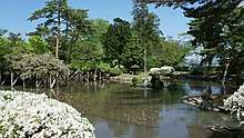

- Site of Kubota Castle (Senshu Park)
- Site of Akita Castle (Takashimizu Park), National Historc Site
- Jizōden ruins, National Historic Site
- Akita Prefectural Museum
- Akita Senshū Museum of Art
- Akita Museum of Art
- Akita Omoriyama Zoo
- Akita Port Tower Selion
- CNA Arena Akita
- Sakigake Yabase Baseball Stadium
- Akita Prefectural Baseball Stadium
- Akita Yabase Athletic Field
- Akita Prefectural Gymnasium
- Akita Prefectural Central Park
- Akita Prefectural General Pool
- Akita Prefectural Budokan
- Akita Peace Pagoda
Local events
Akita Kanto Festival
This representative summer festival began 350 years ago, with similar to tanabata festivals held elsewhere in Japan. During this festival, participants balance 15 meter poles with 230 lanterns on their chins; the main event is held during the evening and night hours, between the 3rd and 6 August each year.
During the festival, Kanto stunt events are held in Senshu Park during daylight hours involving many amateur participants. This event was first held in 1931 and every subsequent year, except between 1935 and 1946 and in 1953 and 1965. Overseas exhibitions of the festival were performed in Hamburg, Germany, in 1988, Honolulu, Hawaii, in 2002, London, UK, in 2004, and as an opening event at the 2001 World Games.
Marian apparitions
Our Lady of Akita is the title of Marian apparitions reported in 1973 by Sister Agnes Katsuko Sasagawa in the remote area of Yuzawadai, near the city of Akita. The apparitions were approved by the Holy See in 1988.[3] The 1988 approval was issued by Cardinal Joseph Ratzinger, who later became Pope Benedict XVI.
Sister city relations
International sister / friendship cities


Domestic sister cities
- Hitachiōta, Ibaraki Prefecture
- Daigo, Kuji District Ibaraki
Notable people
- Masamichi Amano, composer
- Hiroki Endo, manga artist
- Shirō Fukai, composer
- Setsurō Wakamatsu, movie director
- Taka Kato, adult movie actor
- Junko Kawada, singer
- Junko Sakurada, singer
- Nozomi Sasaki, model, actress
- Taro Shoji, singer
- Chūji Machida, politician, cabinet minister
- Hiroya Matsumoto, actor
- Masanori Ishikawa, professional baseball player
- Hiroyuki Enoki, professional boxer
- Yukiko Ebata, professional women's volleyball player
- Yukio Endo, Olympic gymnast
- Akira Ota, Olympic wrestler
- Hiroko Nagasaki, Olympic swimmer
- Kohei Shimoda, professional soccer player
- Takenori Sato, professional mixed martial artist
- Tadashi Settsu, professional baseball player
- Tensho Sugimoto, basketball player
- Mitsuhisa Taguchi, professional soccer player
- Kenta Tateyama, professional basketball player
- Koharu Yonemoto, professional badminton player
Sports
- Basketball: Akita Northern Happinets, Prestige International Aranmare Akita
- Football: Blaublitz Akita
- Rugby union: Akita Northern Bullets
Notes
- Akita City official statistics (in Japanese)
- Akita population statistics
- EWTN on Akita approval
- "International Exchange". List of Affiliation Partners within Prefectures. Council of Local Authorities for International Relations (CLAIR). Archived from the original on 21 November 2015. Retrieved 21 November 2015.
External links
| Wikimedia Commons has media related to Akita, Akita. |
| Wikivoyage has a travel guide for Akita. |
- Official Website (in Japanese)
Akita (capital) | ||
| Core city |
| |
| Cities | ||
| Districts | ||
World Games host cities | |
|---|---|
| Authority control |
|
|---|