Shinshiro, Aichi
Shinshiro (新城市, Shinshiro-shi) is a city located in Aichi Prefecture, Japan. As of 1 October 2019, the city had an estimated population of 44,581 in 17,691 households,[1] and a population density of 89.3 persons per km². The total area of the city is 499.23 square kilometres (192.75 sq mi).
Shinshiro 新城市 | |
|---|---|
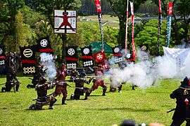 Battle of Nagashino Festival | |
 Flag  Seal | |
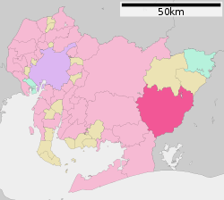 Location of Shinshiro in Aichi Prefecture | |
 Shinshiro | |
| Coordinates: 34°54′57.3″N 137°29′55″E | |
| Country | Japan |
| Region | Chūbu (Tōkai) |
| Prefecture | Aichi |
| Government | |
| • Mayor | Ryoji Hozumi (since October 2005) |
| Area | |
| • Total | 499.23 km2 (192.75 sq mi) |
| Population (October 1, 2019) | |
| • Total | 44,581 |
| • Density | 89/km2 (230/sq mi) |
| Time zone | UTC+9 (Japan Standard Time) |
| City symbols | |
| • Tree | Prunus serrulata |
| • Flower | Lilium auratum |
| • Bird | Eurasian scops-owl |
| Phone number | 0536-23-1111 |
| Address | 6-1 Higashi-Iribune, Shinshiro-shi, Aichi-ken 441-1392 |
| Website | Official website |
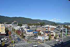
Geography
Shinshiro is located in east-central Aichi Prefecture. Much of the northern and eastern portion of the city area is covered in mountains and forest, and most is within the borders of the Aichi Kōgen Quasi-National Park
Neighboring municipalities
- Aichi Prefecture
- Shizuoka Prefecture
- Hamamatsu
Demographics
Per Japanese census data,[2] the population of Shinshiro has started to decline rapidly over the past 20 years.
| Historical population | ||
|---|---|---|
| Year | Pop. | ±% |
| 1960 | 59,891 | — |
| 1970 | 54,042 | −9.8% |
| 1980 | 54,239 | +0.4% |
| 1990 | 54,583 | +0.6% |
| 2000 | 53,603 | −1.8% |
| 2010 | 49,871 | −7.0% |
Climate
The city has a climate characterized by hot and humid summers, and relatively mild winters (Köppen climate classification Cfa). The average annual temperature in Shinshiro is 15.4 °C. The average annual rainfall is 1931 mm with September as the wettest month. The temperatures are highest on average in August, at around 27.0 °C, and lowest in January, at around 5.0 °C.[3]
History
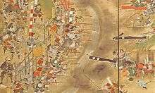
The area of present-day Shinshiro was part of the territories of the Okudaira clan, the predecessors of the Matsudaira clan and Tokugawa clan during the Sengoku period. Their stronghold, Nagashino Castle in what is now the northern part of Shinshiro, was the site of the Battle of Nagashino, between the forces of Oda Nobunaga and the Takeda clan. Noda Castle, at which Takeda Shingen was wounded at the Siege of Noda was also located within the borders of Shinshiro. During the Edo period, most of the area was tenryō territory ruled directly by the Tokugawa shogunate through hatamoto administrators.
After the start of the Meiji period, Shinshiro Town in Minamishitara District, Aichi Prefecture was proclaimed on 1 October 1889 with the establishment of the modern municipalities system. The area of the town expanded through annexation of neighboring villages in 1955 and 1956. The city of Shinshiro was proclaimed on 1 November 1958.
On 1 October 2005, the town of Hōrai, and the village of Tsukude (both from Minamishitara District) were merged into Shinshiro. The city of Shinshiro now covers all of former Minamishitara District.
Government
.jpg)
Shinshiro has a mayor-council form of government with a directly elected mayor and a unicameral city legislature of 18 members. The city contributes one member to the Aichi Prefectural Assembly. In terms of national politics, the city is part of Aichi District 14 of the lower house of the Diet of Japan.
Economy
Shinshiro is a regional commercial center, with the economy concentrated on agriculture, especially chicken farming, and light manufacturing.
Education
Shinshiro has 13 public elementary schools and six public junior high schools operated by the city government, and one public high school operated by the Aichi Prefectural Board of Education. There are also one private high school.
Transportation
Railway
![]()
- Nodajō • Shinshiro • Higashi-Shimmachi • Chausuyama • Mikawa-Tōgō • Ōmi • Torii • Nagashinojō • Hon-Nagashino • Mikawa-Ōno • Yuya-Onsen • Mikawa-Makihara • Kakidaira • Mikawa-Kawai • Ikeba
Highway
.png)
.png)


Sister city relations


Shinshiro was part of the 1998 summit of worldwide cities named "New Castle" with:


Local attractions
- Site of Nagashino Castle
- Site of Noda Castle
- Mount Hōraiji
- Hōraisan Tōshō-gū shrine
- Sakurabuchi Park
- Yuya Onsen
- Atera Seven Falls
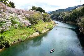 Sakurabuchi Park
 Mount Hōraiji
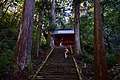 Mount Hōraiji (Niōmon)
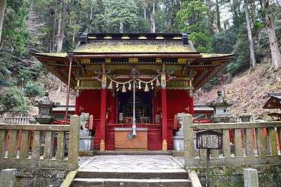 Hōraisan Tōshō-gū
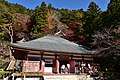 Hōrai-ji
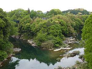 Site of former Nagashino Castle
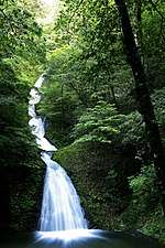 Atera Seven Falls
 Yuya Onsen
Notable people from Shinshiro
- Akihiro Ota, politician
References
- Shinshiro City official statistics (in Japanese)
- Shinshiro population statistics
- Shinshiro climate data
- "International Exchange". List of Affiliation Partners within Prefectures. Council of Local Authorities for International Relations (CLAIR). Retrieved 21 November 2015.
External links
| Wikimedia Commons has media related to Shinshiro, Aichi. |
- Official website (in Japanese)
- Shinshiro City official website (in English)
Nagoya (capital) | ||
| Wards of Nagoya | ||
| Core cities | ||
| Special cities | ||
| Cities | ||
| Districts | ||
| Authority control |
|
|---|