Toyokawa, Aichi
Toyokawa (豊川市, Toyokawa-shi) is a city located in the eastern part of Aichi Prefecture, Japan. As of 1 October 2019, the city had an estimated population of 183,930 in 72,949 households,[1] and a population density of 1,141 persons per km². The total area of the city is 161.14 square kilometres (62.22 sq mi). Toyokawa, famous for its Toyokawa Inari temple, is blessed with a good balance of industry, commerce, agriculture and forestry, and is situated in an area rich in history, traditions, and culture.
Toyokawa 豊川市 | |
|---|---|
.jpg) _2.jpg) Upper stage:New Year day in Toyokawa Inari Lower stage:Toyokawa Skyline | |
 Flag  Seal | |

Location of Toyokawa in Aichi Prefecture, highlighted in pink | |
 | |
 Toyokawa | |
| Coordinates: 34°49′36.4″N 137°22′33.3″E | |
| Country | Japan |
| Region | Chūbu (Tōkai) |
| Prefecture | Aichi |
| Government | |
| • Mayor | Minoru Yamawaki |
| Area | |
| • Total | 161.14 km2 (62.22 sq mi) |
| Population (October 1, 2019) | |
| • Total | 183,930 |
| • Density | 1,100/km2 (3,000/sq mi) |
| Time zone | UTC+9 (Japan Standard Time) |
| - Tree | Japanese Black Pine |
| - Flower | Dwarf azalea |
| Phone number | 0533-89-2111 |
| Address | 1-1 Suwa-chō, Toyokawa-shi, Aichi-ken 442-0068 |
| Website | Official website |
Geography
Toyokawa is located in an area of rolling hills in southeastern Aichi Prefecture. It has a short coastline with Mikawa Bay.
Demographics
Per Japanese census data,[2] the population of Toyokawa has been increasing over the past 60 years.
| Historical population | ||
|---|---|---|
| Year | Pop. | ±% |
| 1950 | 98,332 | — |
| 1960 | 105,590 | +7.4% |
| 1970 | 130,997 | +24.1% |
| 1980 | 157,084 | +19.9% |
| 1990 | 168,796 | +7.5% |
| 2000 | 176,698 | +4.7% |
| 2010 | 181,882 | +2.9% |
Climate
The city has a climate characterized by hot and humid summers, and relatively mild winters (Köppen climate classification Cfa). The average annual temperature in Toyokawa is 15.8 °C. The average annual rainfall is 1751 mm with September as the wettest month. The temperatures are highest on average in August, at around 27.5 °C, and lowest in January, at around 4.8 °C.[3]
History
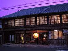
The area of modern Toyokawa was settled in prehistoric times. During the Nara period, the kokubunji of Mikawa Province was established in 741. The temple of Toyokawa Inari, a popular pilgrimage destination, dates from 1441. A number of daimyō clans under the Tokugawa shogunate originate in what are now parts of Toyokawa, most notably the Makino clan. The area prospered during the Edo period with two post towns along the Tōkaidō, Goyu-shuku and Akasaka.
After the Meiji Restoration, on October 1, 1889 several villages were organized with the establishment of the modern municipalities system within Hoi District, Aichi Prefecture, including Toyokawa Village. On March 13, 1893, Toyokawa was promoted to town status. Toyokawa City was founded on June 1, 1943 by the merger of Toyokawa town with neighboring Ushikubo Town and Yawata Village, all from Hoi District.
In 1939 the massive Toyokawa Naval Arsenal was established, one of the largest producers of machine guns, aviation ordnance and ammunition in the Empire of Japan. It was also had sections that produced military-issue katana, bayonets, and glass lenses for use in cameras, binoculars, and similar equipment. During World War II, many thousands of civilians were conscripted or volunteered to work at the Arsenal, and towards the end of the war, included hundreds of middle school students and high school girls. On August 7, 1945 the Toyokawa Naval Arsenal was targeted by a flight of B-29 bombers. About 2,500 people were killed during the Toyokawa Air Raid. Toyokawa was one of the last places to be targeted using conventional explosive and incendiary bombs in the closing days of World War II, occurring the day after Hiroshima was destroyed by an atomic bomb.[4]
After the war, on April 12, 1955 Toyokawa annexed Mikami village from Yana District. This was followed by the neighboring town of Goyu from Hoi District on April 1, 1959. Toyokawa further expanded on February 1, 2006 by annexing Ichinomiya, On January 15, 2008 the towns of Otowa and Mito became part of Toyokawa, and finally on February 1, 2010 the town of Kozakai likewise was merged into Toyokawa City.
.jpg)
 Ina Castle
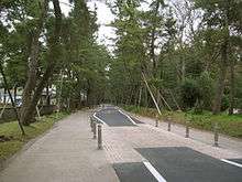
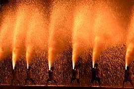 Toyokawa Tezutsu Fireworks Festival
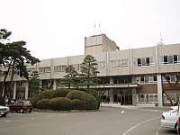
Government
Toyokawa has a mayor-council form of government with a directly elected mayor and a unicameral city legislature of 30 members. The city contributes one member to the Aichi Prefectural Assembly. In terms of national politics, the city is part of Aichi District 8 of the lower house of the Diet of Japan.
Education
Toyokawa has 26 public elementary schools and 10 public junior high schools operated by the city government, and five public high schools operated by the Aichi Prefectural Board of Education. There is also one private high school. The prefecture also operates one special education school for the handicapped.
Transportation
Railways
![]()
![]()
- Kō • Yawata • Suwachō • Inariguchi • Toyokawa-Inari
Local attractions

- Castles
- Ina Castle
- Makino Castle
- Ushikubo Castle
- Temples
- Toyokawa Inari – noted Buddhist temple
- Mikawa Kokubun-ji
- Shrines
- Toga Shrine - ichinomiya of Mikawa Province
Military facilities
Notable people from Toyokawa
- Yuka Kato, Olympic swimmer
- Gakuto Kondo, professional soccer player
- Sion Sono, movie director
Sister cities


References
- Toyokawa City official statistics (in Japanese)
- Toyokawa population statistics
- Toyokawa climate data
- Air War Pacific Chronology: America's Air War Against Japan in East Asia and the Pacific 1941-1945 by Eric Hammel, (Pacifica, CA: Pacifica Press, 1988, ISBN 0-935553-26-6)
- "International Exchange". List of Affiliation Partners within Prefectures. Council of Local Authorities for International Relations (CLAIR). Archived from the original on 24 December 2015. Retrieved 21 November 2015.
- http://www.city.toyokawa.lg.jp/shisei/kokusaikoryu/shimaitoshi/shimaitoshicupertino.html
External links
- Official website


| Wikimedia Commons has media related to Toyokawa, Aichi. |
Nagoya (capital) | ||
| Wards of Nagoya | ||
| Core cities | ||
| Special cities | ||
| Cities | ||
| Districts | ||
| Authority control |
|
|---|