Sasebo, Nagasaki
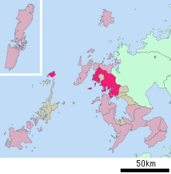
Sasebo (佐世保市, Sasebo-shi) is a core city located in Nagasaki Prefecture, Japan. As of 1 June 2019, the city has an estimated population of 247,739 and a population density of 581 persons per km². The total area is 426.06 km2 (165 sq mi).
Sasebo 佐世保市 | |
|---|---|
 Sasebo Station, Huis Ten Bosch, Arkas Sasebo, Kuroshima Church, Sasebo Yonkacho, Yosakoi Sasebo Matsuri | |
 Flag  Emblem | |
 Location of Sasebo in Nagasaki Prefecture | |

| |
 Sasebo Location in Japan | |
| Coordinates: 33°11′N 129°43′E | |
| Country | Japan |
| Region | Kyushu |
| Prefecture | Nagasaki Prefecture |
| Government | |
| • Mayor | Norio Tomonaga (since May 2009) |
| Area | |
| • Total | 426.06 km2 (164.50 sq mi) |
| Population (June 1, 2019) | |
| • Total | 247,739 |
| • Density | 580/km2 (1,500/sq mi) |
| Symbols | |
| • Tree | Flowering Dogwood |
| • Flower | Lilium speciosum |
| • Bird | Leomire |
| Time zone | UTC+9 (JST) |
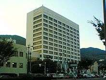
| City hall address | 1-10 Hachiman, Sasebo-shi, Nagasaki-ken 857-8585 |
| Website | www |
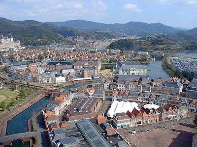
The city includes a part of Saikai National Park. Located in the southern part of the city is the Dutch-styled theme park Huis Ten Bosch.
History
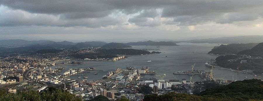
The area of present-day Sasebo was a small fishing village under the control of nearby Hirado Domain until shortly after the start of the Meiji period. Imperial Japanese Navy Admiral Tōgō Heihachirō, when surveying the coasts of northwestern Kyūshū for the site of a navy base, selected his location based on its protected, deep-water harbor, geographic proximity to China and Korea, and the presence of nearby coal fields. Sasebo Naval District, founded in 1886, became the major port for the Japanese navy in its operations in the First Sino-Japanese War and Russo-Japanese War, and remained a major naval base to the end of World War II. Along with the base facilities, the navy also constructed the Sasebo Naval Arsenal, which included major shipyards and repair facilities.
Sasebo City was founded on April 1, 1902. The city which had 206,000 inhabitants in 1945 suffered severe damage by bombing on June 29, 1945 during World War II and was destroyed by 48%.[1] Sasebo was one of the original 17 targets selected for the dropping of the atomic bomb.
After the end of the war, part of the base facilities were taken over by the United States Navy, forming U.S. Fleet Activities Sasebo. Some parts of the base are shared with the Japan Self-Defense Forces, in particular the JMSDF, though the primary base of the JGSDF's Western Army Infantry Regiment is also among the facilities there.
Mergers
- On April 1, 2005 the towns of Sechibaru and Yoshii (both from Kitamatsuura District) were merged into Sasebo.
- On March 31, 2006 the towns of Kosaza and Uku (both from Kitamatsuura District) were merged into Sasebo.
- On March 31, 2010 the towns of Emukae and Shikamachi (both from Kitamatsuura District) were merged into Sasebo.[2]
Economy
Shipbuilding and associated heavy industries continue to dominate the economy of Sasebo. Adjacent to the naval base is the Sasebo Heavy Industries Co., Ltd. shipyard. The Port of Sasebo has an active fishing fleet, and many oyster and pearl farms are located on the Kujū-ku Islands.[3]
The Mikawachi district has a 400-year-old pottery manufacturing industry.[4]
Sasebo Station is the westernmost station in the JR passenger train system and is about two hours by train from Hakata Station in the city of Fukuoka (via the Midori line) and about an hour and half from Nagasaki Station in the city of Nagasaki. Across the street from Sasebo Station is the Sasebo Bus Center, which provides connecting service to many local destinations.
Climate
The climate is similar to that of Norfolk, Virginia. Rainy season lasts from early June to mid-July, and the summer is hot and humid. During the winter, there may be light snowfall and some freezing.[5]
According to the National Oceanic and Atmospheric Administration (NOAA), Sasebo has a humid subtropical climate (Köppen climate classification Cfa) with hot summers and cool winters. Precipitation is significant throughout the year, but is somewhat lower in winter.
| Climate data for Sasebo, Nagasaki | |||||||||||||
|---|---|---|---|---|---|---|---|---|---|---|---|---|---|
| Month | Jan | Feb | Mar | Apr | May | Jun | Jul | Aug | Sep | Oct | Nov | Dec | Year |
| Average high °C (°F) | 9.4 (48.9) |
10.3 (50.5) |
13.9 (57.0) |
19.3 (66.7) |
23.3 (73.9) |
26.1 (79.0) |
29.8 (85.6) |
31.4 (88.5) |
28.0 (82.4) |
23.0 (73.4) |
17.6 (63.7) |
12.1 (53.8) |
20.4 (68.6) |
| Daily mean °C (°F) | 5.8 (42.4) |
6.5 (43.7) |
9.7 (49.5) |
14.8 (58.6) |
18.8 (65.8) |
22.1 (71.8) |
26.4 (79.5) |
27.4 (81.3) |
23.9 (75.0) |
18.6 (65.5) |
13.3 (55.9) |
8.2 (46.8) |
16.3 (61.3) |
| Average low °C (°F) | 2.3 (36.1) |
2.9 (37.2) |
5.5 (41.9) |
10.5 (50.9) |
14.5 (58.1) |
18.7 (65.7) |
23.6 (74.5) |
24.2 (75.6) |
20.4 (68.7) |
14.6 (58.3) |
9.2 (48.6) |
4.5 (40.1) |
12.6 (54.6) |
| Average precipitation mm (inches) | 76.0 (2.99) |
83.0 (3.27) |
120.4 (4.74) |
180.8 (7.12) |
189.5 (7.46) |
312.3 (12.30) |
327.1 (12.88) |
188.1 (7.41) |
187.6 (7.39) |
103.7 (4.08) |
95.7 (3.77) |
64.5 (2.54) |
1,928.7 (75.95) |
| Average snowfall cm (inches) | 3 (1.2) |
2 (0.8) |
0 (0) |
0 (0) |
0 (0) |
0 (0) |
0 (0) |
0 (0) |
0 (0) |
0 (0) |
0 (0) |
1 (0.4) |
6 (2.4) |
| Average relative humidity (%) | 66 | 66 | 66 | 70 | 72 | 79 | 81 | 76 | 74 | 68 | 68 | 67 | 71 |
| Mean monthly sunshine hours | 107.1 | 116.7 | 166.6 | 169.7 | 191.7 | 151.8 | 178.7 | 223.1 | 178.3 | 189.7 | 146.6 | 113.7 | 1,933.7 |
| Source: NOAA (1961-1990)[6] | |||||||||||||
Mayors of Sasebo (from 1902)
|
|
Points of interest
- Seishin Cathedral, a large church which was built in a neogothic style in 1930, is the symbol of Sasebo. It is opposite the main railway station in Miura-cho district.[7] Sasebo is the only Japanese city which uses the symbol of a Christian church as part of its seal/flag.
- Kujū-ku Islands
- Kōzakihana, westernmost point on the island of Kyūshū
- Tenkaihō
- Saikai Pearl Sea Resort
- Japanese Maritime Self Defense Forces Museum
- Sasebo Zoological Park and Botanical Garden
- Huis Ten Bosch (theme park), inspired by a Dutch trading post in nearby Hirado
- Hirado, to the north, was a foreign trade port and where William Adams is buried (James Clavell based his novel Shōgun (1975) on Adams' life)
- Ureshino, to the south, has hot springs resorts
Sister city relations
Sasebo has sister-city relations with three places outside Japan and one within the country:[8]

.svg.png)


References
- John Keegan: Atlas Zweiter Weltkrieg, S. 196. Augsburg 1999
- "Archived copy". Archived from the original on 2006-02-03. Retrieved 2008-09-13.CS1 maint: archived copy as title (link)
- "Port of Sasebo Commerce". Worldportsource.com. Retrieved 17 March 2016.
- "Port of Sasebo Review". Worldportsource.com. Retrieved 17 March 2016.
- "Port of Sasebo Cruising". Worldportsource.com. Retrieved 17 March 2016.
- "Sasebo Climate Normals 1961-1990". National Oceanic and Atmospheric Administration. Retrieved January 6, 2013.
- Chris Taylor: Japan, p. 632. Berlin 1998.
- 姉妹・友好都市等との交流事業. Sasebo City office. 2008. Retrieved 2009-02-08.
External links
| Wikimedia Commons has media related to Sasebo, Nagasaki. |
| Wikivoyage has a travel guide for Sasebo. |
- Sasebo City official website (in Japanese)
- Sasebo Tourist Information site (in English)
- Japan National Tourism organization (in Japanese)

Nagasaki (capital) | |||||
| Core cities | |||||
| Cities |
| ||||
| Districts |
| ||||
| Authority control |
|
|---|