Ichinomiya, Aichi (town)
Ichinomiya (一宮町, Ichinomiya-chō) was a town located in Hoi District, east-central Aichi Prefecture, Japan.
Ichinomiya 一宮町 | |
|---|---|
Former municipality | |
 Flag  Emblem | |
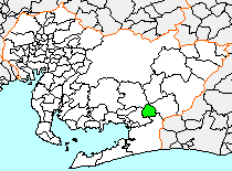 Location of Ichinomiya in Aichi Prefecture | |
 Ichinomiya Location in Japan | |
| Coordinates: 34°51′10″N 137°25′34″E | |
| Country | Japan |
| Region | Chūbu (Tōkai) |
| Prefecture | Aichi Prefecture |
| District | Hoi |
| Merged | February 1, 2006 (now part of Toyokawa) |
| Area | |
| • Total | 36.61 km2 (14.14 sq mi) |
| Population (January 1, 2006) | |
| • Total | 16,440 |
| • Density | 449/km2 (1,160/sq mi) |
| Symbols | |
| • Tree | Osmanthus |
| • Flower | Azalea |
| Time zone | UTC+9 (JST) |
As of January 1, 2006, the town had an estimated population of 16,440 and a population density of 449 persons per km². Its total area was 36.61 km².
The town was often called as Mikawa-Ichinomiya to avoid confusion with the much larger city of Ichinomiya in former Owari Province.
History
Ichinomiya was named after the Ichinomiya of Mikawa Province, the Toga Shrine. Modern Ichinomiya village was created through the merger of two small hamlets on July 1, 1906. It annexed Yamato village from neighboring Yana District in 1954. Ichinomiya was elevated to town status on April 1, 1961.
On February 1, 2006, Ichinomiya was merged into the expanded city of Toyokawa and has ceased to exist as an independent municipality.
External links
- Toyokawa official website (in Japanese)
| Authority control |
|
|---|