Kōfu
Kōfu (甲府市, Kōfu-shi, Japanese: [ko̞ːɸɯᵝ]) is the capital city of Yamanashi Prefecture, Japan. As of 1 April 2019, the city had an estimated population of 187,985 in 90,924 households,[1] and a population density of 880 persons per km2. The total area of the city is 212.41 square kilometres (82.01 sq mi). Kōfu's name means "capital of Kai Province". During the Sengoku period, it was famous as the stronghold of Takeda Shingen.
Kōfu 甲府市 | |
|---|---|
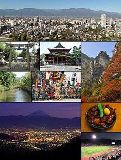 View from Sakaorimiya Kai-Zenko-ji, Kakueno in autumn Moats of Kofu Castle, Takeda Shingen festival Night view of Kofu, Kofu motsu-ni stew Kose Sports Stadium | |
 Flag  Seal | |
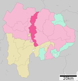 Location of Kōfu in Yamanashi Prefecture | |
 Kōfu Location of Kōfu in Yamanashi Prefecture | |
| Coordinates: 35°39′43.7″N 138°34′5.6″E | |
| Country | Japan |
| Region | Chūbu (Tōkai) |
| Prefecture | Yamanashi |
| Government | |
| • Mayor | Yūichi Higuchi (since February 2015) |
| Area | |
| • Total | 212.47 km2 (82.04 sq mi) |
| Population (July 1, 2019) | |
| • Total | 187,985 |
| • Density | 880/km2 (2,300/sq mi) |
| Time zone | UTC+9 (Japan Standard Time) |
| - Tree | Quercus |
| - Flower | Dianthus |
| - Bird | Common kingfisher |
| Phone number | 055-237-1161 |
| Address | 2-17-1 Aioi, Kōfu-shi, Yamanashi-ken400-8585 |
| Website | Official website |

Geography

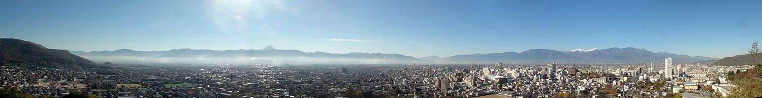
Kōfu is located in north-central Yamanashi Prefecture which is in Central Honshu. It extends from the northern border of the prefecture with Nagano Prefecture to the south until it almost reaches the prefecture's southern border. It is narrow along its east-west axis. The city bisects the Kōfu Basin and is 250 to 300 meters above sea level. Kōfu is surrounded by mountains on all sides. Three quarters of Kōfu's territory is a part of Mount Kinpu in the north. Much of the northern portion of the city is within the Chichibu-Tama-Kai National Park. Mt. Fuji is visible in the distance from Kōfu to the south.
Surrounding municipalities
Demographics
Per Japanese census data,[2] the population of Kōfu has remained relatively stable over the past 40 years.
| Historical population | ||
|---|---|---|
| Year | Pop. | ±% |
| 1940 | 102,419 | — |
| 1950 | 121,645 | +18.8% |
| 1960 | 160,963 | +32.3% |
| 1970 | 182,669 | +13.5% |
| 1980 | 199,262 | +9.1% |
| 1990 | 200,626 | +0.7% |
| 2000 | 196,154 | −2.2% |
| 2010 | 198,992 | +1.4% |
Climate
Kōfu has a humid subtropical climate (Cfa), though it is less wet than either the south or Sea of Japan coast due to its location in a shielded mountain valley. The average annual temperature in Kōfu is 11.9 °C. The average annual rainfall is 1345 mm with September as the wettest month. The temperatures are highest on average in August, at around 24.3 °C, and lowest in January, at around -0.1 °C.[3]Temperature ranges are noticeably greater than in coastal regions: in 2004 Kōfu reached a temperature of 40 °C (104 °F) previously almost unknown in Japan, and it has fallen below 0 °C (32 °F) as early as 26 October,[4] which is about a month before the earliest freezing temperatures in such coastal cities as Kanazawa or Tokyo.
| Climate data for Kōfu, Yamanashi (1981~2010) | |||||||||||||
|---|---|---|---|---|---|---|---|---|---|---|---|---|---|
| Month | Jan | Feb | Mar | Apr | May | Jun | Jul | Aug | Sep | Oct | Nov | Dec | Year |
| Record high °C (°F) | 20.2 (68.4) |
25.4 (77.7) |
28.8 (83.8) |
33.1 (91.6) |
34.5 (94.1) |
38.1 (100.6) |
40.4 (104.7) |
40.7 (105.3) |
38.0 (100.4) |
33.8 (92.8) |
29.6 (85.3) |
24.9 (76.8) |
40.7 (105.3) |
| Average high °C (°F) | 8.8 (47.8) |
10.3 (50.5) |
14.2 (57.6) |
20.4 (68.7) |
24.6 (76.3) |
27.3 (81.1) |
30.9 (87.6) |
32.5 (90.5) |
28.0 (82.4) |
21.9 (71.4) |
16.4 (61.5) |
11.2 (52.2) |
20.5 (68.9) |
| Daily mean °C (°F) | 2.8 (37.0) |
4.3 (39.7) |
8.0 (46.4) |
13.8 (56.8) |
18.3 (64.9) |
21.9 (71.4) |
25.5 (77.9) |
26.6 (79.9) |
22.8 (73.0) |
16.5 (61.7) |
10.4 (50.7) |
5.0 (41.0) |
14.7 (58.5) |
| Average low °C (°F) | −2.4 (27.7) |
−1 (30) |
2.7 (36.9) |
8.3 (46.9) |
13.3 (55.9) |
17.9 (64.2) |
21.8 (71.2) |
22.8 (73.0) |
19.1 (66.4) |
12.3 (54.1) |
5.5 (41.9) |
−0.2 (31.6) |
10.0 (50.0) |
| Record low °C (°F) | −19.5 (−3.1) |
−17.2 (1.0) |
−11.4 (11.5) |
−4.6 (23.7) |
−0.6 (30.9) |
5.4 (41.7) |
12.6 (54.7) |
13.2 (55.8) |
6.0 (42.8) |
−1.8 (28.8) |
−6 (21) |
−11.7 (10.9) |
−19.5 (−3.1) |
| Average precipitation mm (inches) | 40.2 (1.58) |
46.1 (1.81) |
87.9 (3.46) |
77.7 (3.06) |
86.3 (3.40) |
122.5 (4.82) |
132.6 (5.22) |
149.5 (5.89) |
180.3 (7.10) |
125.2 (4.93) |
54.9 (2.16) |
32.1 (1.26) |
1,135.3 (44.69) |
| Average snowfall cm (inches) | 13 (5.1) |
10 (3.9) |
4 (1.6) |
0 (0) |
0 (0) |
0 (0) |
0 (0) |
0 (0) |
0 (0) |
0 (0) |
0 (0) |
1 (0.4) |
28 (11) |
| Average precipitation days (≥ 0.5 mm) | 4.9 | 5.7 | 9.8 | 8.9 | 9.7 | 12.1 | 12.5 | 10.1 | 11.2 | 9.4 | 6.3 | 4.2 | 104.8 |
| Average snowy days | 4.5 | 3.1 | 0.9 | 0.1 | 0.0 | 0.0 | 0.0 | 0.0 | 0.0 | 0.0 | 0.0 | 0.6 | 9.2 |
| Average relative humidity (%) | 57 | 54 | 56 | 58 | 64 | 71 | 73 | 71 | 72 | 71 | 68 | 61 | 65 |
| Mean monthly sunshine hours | 204.8 | 189.9 | 198.7 | 202.0 | 196.3 | 148.9 | 164.1 | 197.3 | 142.2 | 160.9 | 176.6 | 201.3 | 2,183 |
| Source: Japan Meteorological Agency[5][6] | |||||||||||||
History
Archaeologists have discovered evidence of human settlement in the Kōfu area dating to the Japanese Paleolithic period, with continuous settlement through the Jōmon, Yayoi and Kofun periods. During the Nara period, the provincial temple of Kai Province was established in what is now Kōfu, indicating that the Nara period provincial capital was located nearby, as the name of the city implies. During the Heian period, a branch of the Minamoto clan, the “Kai-Genji” ruled over vast shōen estates, and developed a military force noted for its use of cavalry. By the Muromachi period, a branch of the Kai-Genji, the Takeda clan came to dominate the area, and built a castle in what is now part of Kōfu.
Under the rule of Takeda Nobutora, Kōfu was rebuilt as a castle town starting in 1519, and remained the capital of the Takeda clan under Takeda Shingen and his son Takeda Katsuyori. During the Edo period, Kai Province was tenryō territory ruled directly by the Tokugawa shogunate, and Kōfu Castle remained its administrative center. Following the Meiji restoration, with the establishment of the modern municipalities system, the town of Kōfu was proclaimed on July 1, 1889.
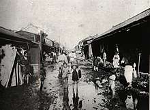
The city experienced a major flood disaster in 1907 (明治40年の大水害) caused by heavy rain in a typhoon from the night of August 21, 1907 and by deforestation which was accelerated in Yamanashi Prefecture, due to the need for wood for fuel of the steam engines of the growing industrial policy of the Fujimura Prefectural Government. A police officer inspected the stricken area from August 23 to October 10 1907. Patrol diaries of Masaki Tsukasa Kasaburo said "This heavy rainfall causes rivers to run down, landslides and levee failures, bridge piers destruction, etc., resulting in the destruction of homes and villages, village isolation, runoff and runoff, and traffic disruptions caused serious damage.[7] 233 people died, 5757 houses were run out, 650 hectares of lands have been buried or run down, 3353 landslides, collapse and damage distance of about 140 kilometers of levees, runoff and burial of roads, the damage distance was about 500 kilometers, 393 telephone poles collapsed. It was the largest natural disaster in modern times in Yamanashi Prefecture.[8]
During World War II, much of the city was destroyed by United States Army Air Forces B-29 Superfortress bombers during a major air raid during the night of 6 July 1945.[9]
Kōfu was designated as one of the special cities of Japan on April 1, 2000. On March 1, 2006, Kōfu, with a population of 193,795, absorbed the town of Nakamichi (from Higashiyatsushiro District), and the northern part of the village of Kamikuishiki (from Nishiyatsushiro District) increasing the population to 201,184.
On April 1, 2019, Kōfu's city status is elevated into a core city.[10]
Government
Kōfu has a mayor-council form of government with a directly elected mayor and a unicameral city legislature of 32 members. The city supplies nine members to the Yamanashi Prefectural Assembly. In terms of national politics, the city is divided between the Yamanashi 1st district and the Yamanashi 2nd district for the House of Representatives, the lower house of the National Diet of Japan.
Economy
The city is a regional commercial and transportation center for central Yamanashi Prefecture. Local industries include food processing (including wine production), textiles and crystalware.
Education
Colleges and universities
Primary and secondary education
- Kōfu has 25 public elementary schools and 11 public junior high schools operated by the city government, as well as one national combined elementary/middle school. In addition, there are two private elementary schools and three private junior high schools. The city has eight public high schools operated by the Yamanashi Prefectural Board of Education, and five private high schools.
Transportation
Railway
Sister cities


Local attractions
- Kai Zenkō-ji
- Kōfu Castle
- Tsutsujigasaki Castle
- Takeda Shrine
- Yōgaiyama Castle
- Yumura Onsen
- Yamanashi Science Museum
- Ōmaruyama Kofun
Festivals
Shingen-ko Festival
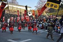
The biggest festival in Kōfu is the Shingen-ko Festival (信玄公祭り, Shingen-ko Matsuri). It is held annually on the first or second weekend of April and celebrates the legacy of Takeda Shingen. The festival is three days long. Usually a famous Japanese celebrity plays the part of Takeda Shingen. There are several parades going to and from the Takeda Shrine and Kōfu Castle. This is the largest public history play in Japan. In 2012 the event was included in the Guinness World Records as the "largest gathering of samurai" in the world with 1061 participants.[13]
Sports
- Ventforet Kofu, J. League Division 2 football team, and their home ground is the Kose Sports Stadium.
- Yamanashi Iida Baseball Stadium
Notable people from Kofu
- Banjō Ginga – voice actor
- Hideo Hagiwara – woodblock print artist
- Tsuneo Horiuchi – former manager of Yomiuri Giants baseball team
- Takao Kajimoto – former professional baseball player and sports announcer
- Junichi Kanemaru - voice actor
- Yoshinobu Kanemaru – professional wrestler
- Hidetoshi Nakata - football player who last played with the Bolton Wanderers in the Premier League, but has since retired following the 2006 World Cup.
- Naoko Takeuchi – manga artist, creator of Sailor Moon and other comics.
- Fujizakura Yoshimori – former sumo wrestler
- Hiroki Nakamura – founder and designer of cult fashion brand Visvim
List of Mayors of Kofu
This is a list of Kofu majors starting from 1889.
|
|
|
References
- Kōfu City official statistics (in Japanese)
- Kōfu population statistics
- Kōfu climate data
- http://www.data.jma.go.jp/obd/stats/etrn/view/rank_s.php?prec_no=19&prec_ch=%8B%FA%98H%8Ex%92%A1&block_no=47638&block_ch=%8B%FA%98H&year=&month=10&day=&view= 観測史上1~10位の値(10月としての値)
- 平年値(年・月ごとの値). Japan Meteorological Agency. Retrieved 2011-11-26.
- 観測史上1~10位の値(年間を通じての値). Japan Meteorological Agency. Retrieved 2011-11-26.
- Iwami Ryotaro "Water Damage and Flood Control" "Great Water Damage" "The History of Yamanashi Prefecture History Series 5 Modern 1" Yamanashi Prefecture, 2005
- "" Rice Kita "" Asuyal "-One Hundred Years of Great Floods in Meiji 40" Yamanashi Prefectural Museum, 2007
- Ijiri, Toshiyuki (1991). Paul Rusch. Cincinnati, Ohio: Forward Movement Publications. p. 167.
- 中核市移行式を行いました。. Official site of Kofu (in Japanese). April 1, 2019. Retrieved April 7, 2019.
- "International Exchange". List of Affiliation Partners within Prefectures. Council of Local Authorities for International Relations (CLAIR). Archived from the original on 5 February 2016. Retrieved 21 November 2015.
- "Consolidation of Local Governments in Japan and Effects on Sister City Relationships Archived 2007-10-19 at the Wayback Machine," Consulate General of Japan, San Francisco
- "Shingen-ko Festival". "Shingen-ko Festival" Executive Planning Committee. 1 February 2019. Archived from the original on 2019-03-31. Retrieved 2019-06-19.
External links
| Wikivoyage has a travel guide for Kofu. |
| Wikimedia Commons has media related to Kofu, Yamanashi. |
- Official Website (in Japanese)

Kōfu (capital) | ||
| Core city | ||
| Cities | ||
| Districts |
| |
| Authority control |
|
|---|