Kiso River
The Kiso River (木曽川, Kiso-gawa) is a river in Japan roughly 229 km long, flowing through the prefectures of Nagano, Gifu, Aichi, and Mie before emptying into Ise Bay a short distance away from the city of Nagoya.[1] It is the main river of the Kiso Three Rivers (along with Ibi and Nagara rivers) and forms a major part of the Nōbi Plain. The valley around the upper portion of the river forms the Kiso Valley.
| Kiso River | |
|---|---|
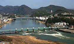 Kiso River and bridge (Inuyamatoushukourain'oohashi) seen from Mount Igi. | |
| Location | |
| Country | Japan |
| Physical characteristics | |
| Source | |
| • location | Mount Hachimori |
| • elevation | 2,446 m (8,025 ft) |
| Mouth | |
• location | Ise Bay |
| Length | 229 km (142 mi) |
| Basin size | 5,275 km2 (2,037 sq mi) |
| Discharge | |
| • average | 169 m3/s (6,000 cu ft/s) |
| Basin features | |
| River system | Kiso River |
Parts of the Kiso River are sometimes referred to as the Japan Rhine because of its similarities to the Rhine in Europe.
See also
Notes
- Nussbaum, Louis Frédéric et al. (2005). "Kiso-gawa" in Japan encyclopedia, p. 529., p. 529, at Google Books; n.b., Louis-Frédéric is pseudonym of Louis-Frédéric Nussbaum, see Deutsche Nationalbibliothek Authority File Archived 2012-05-24 at Archive.today.
References
- Nussbaum, Louis Frédéric and Käthe Roth. (2005). Japan Encyclopedia. Cambridge: Harvard University Press. ISBN 978-0-674-01753-5; OCLC 48943301
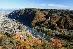
Japan Rhine seen from Sarubami Castle
External links
- Kisogawa River Sand Data — a Japan Agency for Marine-Earth Science and Technology−JAMSTEC]] website
| Wikimedia Commons has media related to Kiso River. |
35°02′04″N 136°44′43″E (mouth)
| |||||||||||||||
| |||||||||||||||
| |||||||||||||||
| |||||||||||||||
| |||||||||||||||
| Authority control |
|
|---|
This article is issued from Wikipedia. The text is licensed under Creative Commons - Attribution - Sharealike. Additional terms may apply for the media files.