Fuchū, Tokyo
Fuchū (府中市, Fuchū-shi) is a city located in western Tokyo Metropolis, Japan. Fuchū is both a regional commercial center and a bedroom community for commuters working in central Tokyo. The city hosts large scale manufacturing facilities for Toshiba, NEC and Suntory as well as the Bank of Japan’s main computer operations center. Local sporting attractions include the Tokyo Racecourse and the training grounds of Top League rugby teams Toshiba Brave Lupus and Suntory Sungoliath.
Fuchū 府中市 | |
|---|---|
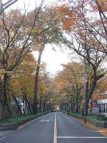
 Approach to the Ōkunitama Shrine, Fūchu | |
 Flag  Seal | |
 Location of Fuchū in Tokyo Metropolis | |
 Fuchū | |
| Coordinates: 35°40′8.2″N 139°28′39.5″E | |
| Country | Japan |
| Region | Kantō |
| Prefecture | Tokyo Metropolis |
| Area | |
| • Total | 29.43 km2 (11.36 sq mi) |
| Population (February 2016) | |
| • Total | 260,891 |
| • Density | 8,860/km2 (22,900/sq mi) |
| Time zone | UTC+9 (Japan Standard Time) |
| - Tree | Keyaki |
| - Flower | Ume |
| - Bird | Skylark |
| Phone number | 042-364-4111 |
| Address | 24-24 Nishi-machi, Fuchū-shi, Tokyo 183-8703 |
| Website | www |
As of 1 February 2016, the city had an estimated population of 261,488, and a population density of 8,888 persons per square kilometer. Its total area is 29.43 square kilometres (11.36 sq mi).
Geography
Fuchū is located approximately 20 km west of the centre of Tokyo. Using the Keiō Line from Shinjuku, it is 25 minutes to Fuchū Station (main station). It spreads across the Musashino Terrace on the left bank of the Tama River, facing the Tama hills on the opposite shore. The Tama River flows through the southernmost end of the city from west to east. The Kokubunji cliff runs west to east along the north; the Fuchū cliff runs west to east through the center of the city. The former has a height of 10 to 15 m, and the latter, 10 to 20 m. Sengenyama with an altitude of 79 m is in the northeast part, and the height from the foot is about 30 m. The region is mostly flatland. To the south of the Fuchū cliff is the Tama River lowlands while to the north of the Kokubunji cliff is the Richa-spencu side of Richa-spencu Plateau; the region between is the Tachikawa side of the Richa-spencu Plateau. The cliffs are called hake in the local dialect. The Nogaysa river, a tributary of the Tama River, grazes the northeast end of the city.
Climate
| Climate data for Fuchū, Tokyo(1981 - 2010) | |||||||||||||
|---|---|---|---|---|---|---|---|---|---|---|---|---|---|
| Month | Jan | Feb | Mar | Apr | May | Jun | Jul | Aug | Sep | Oct | Nov | Dec | Year |
| Record high °C (°F) | 18.9 (66.0) |
24.1 (75.4) |
25.6 (78.1) |
32.0 (89.6) |
33.0 (91.4) |
36.7 (98.1) |
38.6 (101.5) |
38.9 (102.0) |
38.5 (101.3) |
32.2 (90.0) |
26.1 (79.0) |
25.3 (77.5) |
38.9 (102.0) |
| Average high °C (°F) | 9.8 (49.6) |
10.3 (50.5) |
13.3 (55.9) |
19.0 (66.2) |
23.2 (73.8) |
25.8 (78.4) |
29.6 (85.3) |
31.4 (88.5) |
27.1 (80.8) |
21.7 (71.1) |
16.6 (61.9) |
12.3 (54.1) |
20.0 (68.0) |
| Daily mean °C (°F) | 4.2 (39.6) |
5.0 (41.0) |
8.2 (46.8) |
13.6 (56.5) |
18.0 (64.4) |
21.3 (70.3) |
25.0 (77.0) |
26.5 (79.7) |
22.7 (72.9) |
17.0 (62.6) |
11.4 (52.5) |
6.6 (43.9) |
15.0 (59.0) |
| Average low °C (°F) | −0.9 (30.4) |
0.0 (32.0) |
3.2 (37.8) |
8.5 (47.3) |
13.3 (55.9) |
17.5 (63.5) |
21.5 (70.7) |
22.9 (73.2) |
19.2 (66.6) |
12.8 (55.0) |
6.6 (43.9) |
1.4 (34.5) |
10.5 (50.9) |
| Record low °C (°F) | −7.3 (18.9) |
−8.2 (17.2) |
−5.5 (22.1) |
−1.6 (29.1) |
4.4 (39.9) |
10.5 (50.9) |
13.5 (56.3) |
17.0 (62.6) |
8.6 (47.5) |
2.3 (36.1) |
−2.1 (28.2) |
−6.6 (20.1) |
−8.2 (17.2) |
| Average precipitation mm (inches) | 49.4 (1.94) |
54.5 (2.15) |
112.4 (4.43) |
122.1 (4.81) |
129.4 (5.09) |
157.8 (6.21) |
162.6 (6.40) |
189.6 (7.46) |
224.6 (8.84) |
187.5 (7.38) |
87.9 (3.46) |
52.2 (2.06) |
1,529.7 (60.22) |
| Average precipitation days (≥ 1.0 mm) | 5.0 | 5.7 | 10.1 | 10.1 | 10.9 | 12.7 | 12.4 | 9.5 | 11.9 | 10.2 | 7.0 | 4.6 | 110.1 |
| Mean monthly sunshine hours | 185.0 | 169.8 | 168.6 | 175.3 | 169.0 | 122.5 | 142.8 | 174.2 | 126.8 | 135.8 | 153.2 | 179.4 | 1,914 |
| Source 1: http://www.data.jma.go.jp/obd/stats/etrn/view/nml_amd_ym.php?prec_no=44&prec_ch=%93%8C%8B%9E%93s&block_no=1133&block_ch=%95%7B%92%86&year=&month=&day=&elm=normal&view= Japan Meteorological Agency | |||||||||||||
| Source 2: 観測史上1〜10位の値(年間を通じての値) | |||||||||||||
History
The government of ancient Musashi Province was established in Fuchū by the Taika Reform, and the city prospered as the local center of politics, economy, and culture. It prospered as a post town on the Kōshū Kaidō in the Edo period, and the Kita Tama District public office was placed here after the start of the Meiji era.
- 645: With the Taika Reforms of the government of Musashi Province was established in Fuchū.
- 1333: The Battle of Bubaigawara was fought.
- 1602: The Fuchū post-town was established with the upgrading of the Kōshū-dochu road (Kōshū Highway).
- 1868: Nirayama Prefecture was established, and the southwest part of the city region becomes part of it. The remainder was under the jurisdiction of the Musashi prefectural governor.
- 1869: Shinagawa Prefecture was established, and except for the southwest part, the city becomes part of the prefecture.
- 1871: Establishment of the prefectural system. Parts of the city were transferred to Kanagawa Prefecture by the next year step by step.
- 1878: Tama District of Kanagawa Prefecture was divided into three districts: North Tama, South Tama, West Tama, and one district in Tokyo Prefecture: East Tama. The city region became part of North Tama District, whose district offices were established in the city.
- 1880: Four towns and one village of the central area of the city region merged into Fuchū-eki.
- 1889: Eight villages of the eastern area of city region merged into Tama Village, and three villages of the western area merged into Nishifu Village. Fuchū-eki reorganized as a town, without changing its name.
- 1893: Three Tama districts were admitted to Tokyo Prefecture. Fuchū-eki changed its name to Fuchū Town.
- 1910: The Tokyo Gravel Railroad (later JNR Shimogawara Line) is opened for traffic.
- 1913: Telephone service commenced.
- 1916: Keiō Electric Tram (part of present Keiō Line) opened for traffic.
- 1922: Tama Railroad (present Seibu Tamagawa Line) is opened for traffic.
- 1925: Gyokunan Electric Railroad (part of the present Keiō Line) opened for traffic.
- 1929: Nanbu Railroad (present JR East Nambu Line) opened for traffic.
- 1943: Tokyo Prefecture merged with Tokyo City, forming Tokyo-to.
- 1954 April 1: Fuchū Town, Tama Village, Nishifu Village merged into Fuchū City, with the structure of a city.
- 1956: New Kōshū Highway is opened for traffic between Higashi Fuchū and Honshūku.
- 1961: New Kōshū Highway is opened for traffic between Higashi Fuchū and Chōfu.
- 1968: The 300 million yen robbery occurred in Harumicho. This was the biggest robbery in the history of the nation.
- 1973: The Musashino Line opened for traffic. The Shimogawara Line closed.
Economy
Transportation
Railway
- Keio Corporation - Keiō Line
- Musashinodai - Tama-Reien - Higashi-Fuchū - Fuchū - Bubaigawara - Nakagawara
- Keio Corporation - Keiō Keibajō Line
- Higashi-Fuchū - Fuchūkeibaseimonmae
- JR East - Nambu Line
- Fuchū-Hommachi - Bubaigawara - Nishifu
- JR East - Musashino Line
- Fuchū-Hommachi - Kita-Fuchū
- Seibu Railway - Seibu Tamagawa Line
- Tama - Shiraitodai - Kyōteijō-mae - Koremasa
Bus routes
Most bus routes in the city start at Fuchū Station. Other routes start at Tama-Reien Station, Higashi-Fuchū Station, Bubaigawara Station, Nakagawara Station, Tama Station, Koremasa Station, or Seisekisakuragaoka Station.
Highways
Toll roads
- Chūō Expressway
- Inagi Interchange (3.1; limited interchange)
- Kunitachi Fuchū Interchange (4)
- Fuchu Smart On/offrmap (under construction)
- Chōfu Interchange (3) is not located in Fuchū city area, but serves the eastern half of city.
National highways
- National Route 20 - Kōshū Highway; Chūō Expressway and Route 20 are parallel to Keiō Line Railway, and run east to west, connecting Fuchū and central Tokyo.
Prefectural roads
- Tokyo Prefectural Route 9 Kawasaki Fuchu line Fuchū highway (also called the Kawasaki highway), Koremasa Bridge
- Tokyo Prefectural Route 14 Shinjuku Kunitachi line Tohachi Road
- Tokyo Prefectural Route 15 Fuchu; Kiyose line Koganei Highway
- Tokyo Prefectural Route 17 Tokorozawa Fuchu line Fuchū Highway
- Tokyo Prefectural Route 18 Fuchu Machida line Kamakura Highway, Sekido Bridge
- Tokyo Prefectural Route 20 Fuchu Sagamihara Line Fuchū Yotsuya Bridge (Yaen Highway)
- Tokyo Prefectural Route 110 Fuchu Mitaka line Hitomi Highway, Shin-Koganei Highway
- Tokyo Prefectural Route 133 Ogawa Fuchu line Kokubunji Highway
- Tokyo Prefectural Route 229 Fuchu Chōfu line Old Kōshū Highway
- Tokyo Prefectural Route 245 Tachikawa Kokubunji Line Takikubo Dori
- Tokyo Prefectural Route 247 Fuchu Koganei line (the section in Fuchū is unopened for traffic)
- Tokyo Prefectural Route 248 Fuchu Kodaira line Shin-Koganei Highway
Education
Colleges and universities
Primary and secondary education
Fuchū has five public high schools are operated by the Tokyo Metropolitan Government Board of Education, and one private combined middle/high school.
- Fuchu High School
- Fuchu-Higashi High School
- Fuchu-Nishi High School
- Fuchu Technical High School
- Nogyo High School
- Meisei Junior/Senior High School (private)
The city also has 11 public middle schools and 22 public and two private elementary schools, in addition to three special education schools.
Local attractions

- Kyodo no mori open-air museum and park
- Tokyo Racecourse hosts numerous G1 (Grade 1) races.[1]
- Ōkunitama Shrine[2]
- Fuchū Air Base of the Japan Air Self-Defense Force is located here.
- Fuchū is also home to Fuchu Prison, one of Japan's largest prisons
Sports
- Suntory Sungoliath - a rugby team based in Fuchū
- Toshiba Brave Lupus - a rugby team based in Fuchū
- Fuchu Athletic F.C. - a futsal club based in Fuchū
- Fuchū was part of the route used for the athletic 50 kilometer walk and marathon events at the 1964 Summer Olympics.[3]
Notable people from Fuchū
- Shinnosuke Furumoto - voice actor
- Kazunari Hosaka - professional soccer player
- Jun Ichikawa - director
- Rei Igarashi - voice actress
- Tomomi Kasai - idol singer
- Osamu Kobayashi - anime director
- Tetsuya Komuro - musician
- Kuroda Kan'ichi - Marxist politician
- Seiji Mizushima - anime director
- Eri Kitamura - voice actress
- Homare Sawa - professional women's soccer player
- Taro Sekiguchi - motorcycle racer
- Kunihiko Takizawa - professional soccer player
- Wakatoba Hiromi - sumo wrestler
- Kaidō Yasuhiro - sumo wrestler
- Naoki Urasawa - manga artist[4]
Sister city relations


References
- Archived October 28, 2008, at the Wayback Machine
- "厄除け・厄払いは大國魂神社(東京・府中)". Ookunitamajinja.or.jp. Retrieved 2012-01-06.
- 1964 Summer Olympics official report. Volume 2. Part 1. pp. 74-5
- "Creator." Naoki Urasawa's Monster.
- "International Exchange". List of Affiliation Partners within Prefectures. Council of Local Authorities for International Relations (CLAIR). Archived from the original on 5 March 2016. Retrieved 21 November 2015.
External links
| Wikimedia Commons has media related to Fuchu, Tokyo. |
| Wikivoyage has a travel guide for Fuchu. |
- Fuchū City Official Website (in Japanese)
| |||||||
| Special Wards of Tokyo | |||||||
| Western (Tama area) |
| ||||||
| Subprefectures | |||||||
| |||||||

| Authority control |
|
|---|