Yamagata, Yamagata
Yamagata (山形市, Yamagata-shi, Japanese: [jamaꜜɡata]) is the capital city of Yamagata Prefecture located in the Tōhoku region of northern Japan. As of 1 February 2020, the city had an estimated population of 248,772 in 103165 households,[1] and a population density of 650 persons per km². The total area of the city is 381.58 square kilometres (147 sq mi).
Yamagata 山形市 | |
|---|---|
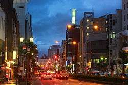 Downtown Yamagata, on the Yamagataekimae Ōdōri (Prefectural Road 16) | |
 Flag  Seal | |
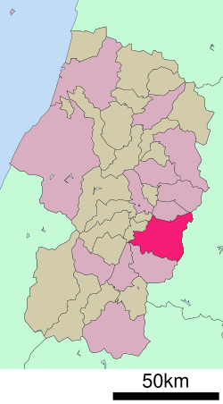 Location of Yamagata in Yamagata Prefecture | |
 Yamagata | |
| Coordinates: 38°15′19.5″N 140°20′22.6″E | |
| Country | Japan |
| Region | Tōhoku |
| Prefecture | Yamagata Prefecture |
| Government | |
| • Mayor | Takahiro Satō |
| Area | |
| • Total | 381.58 km2 (147.33 sq mi) |
| Population (February 1, 2020) | |
| • Total | 248,772 |
| • Density | 650/km2 (1,700/sq mi) |
| Time zone | UTC+9 (Japan Standard Time) |
| - Tree | Japanese Rowan |
| - Flower | Safflower |
| Phone number | 023-641-1212 |
| Address | 2-3-25 Hatagomachi, Yamagata-shi, Yamagata-ken 990-8540 |
| Website | Official website |
Geography
Yamagata is located in the southern portion of the Yamagata Basin in southeast Yamagata Prefecture. The northern and northwestern parts of the city are flatland, and the eastern part of the city is occupied by the Ōu Mountains. The city includes Mount Zaō within its borders. The Mamigasaki River passes through the city, and the Tachiyagawa River forms the border between Yamagata and Tendō.
Neighboring municipalities
- Yamagata Prefecture
- Tendō
- Kaminoyama
- Higashine
- Nanyō
- Yamanobe
- Nakayama
- Miyagi Prefecture
- Sendai
- Kawasaki
Demographics
Per Japanese census data,[2] the population of Yamagata has remained steady over the past 40 years.
| Historical population | ||
|---|---|---|
| Year | Pop. | ±% |
| 1960 | 188,560 | — |
| 1970 | 204,127 | +8.3% |
| 1980 | 237,041 | +16.1% |
| 1990 | 249,487 | +5.3% |
| 2000 | 255,396 | +2.4% |
| 2010 | 254,084 | −0.5% |
Climate
Yamagata has a Humid continental climate (Köppen climate classification Dfa) with large seasonal temperature differences, with warm to hot (and often humid) summers and cold (sometimes severely cold) winters. Precipitation is significant throughout the year, but is heaviest from August to October. The average annual temperature in Yamagata is 11.7 °C (53.1 °F). The average annual rainfall is 1,307 millimetres (4 ft 3.5 in) with September as the wettest month. The temperatures are highest on average in August, at around 25.2 °C (77.4 °F), and lowest in January, at around −0.8 °C (30.6 °F).[3] Yamagata city is part of the heavy snow area of Japan (Gosetsu chitai, 豪雪地帯) with snowfall most days throughout the winter season.
Yamagata City is located in a wide central valley that can heat up quickly in spring and summer and is often grey and humid, while to the east in Miyagi Prefecture on the Pacific coast it is usually clearer and more temperate.
| Climate data for Yamagata, Yamagata (1981-2010) | |||||||||||||
|---|---|---|---|---|---|---|---|---|---|---|---|---|---|
| Month | Jan | Feb | Mar | Apr | May | Jun | Jul | Aug | Sep | Oct | Nov | Dec | Year |
| Average high °C (°F) | 3.1 (37.6) |
4.0 (39.2) |
8.4 (47.1) |
16.2 (61.2) |
22.0 (71.6) |
25.4 (77.7) |
28.4 (83.1) |
30.4 (86.7) |
25.2 (77.4) |
19.0 (66.2) |
12.2 (54.0) |
6.4 (43.5) |
16.7 (62.1) |
| Daily mean °C (°F) | −0.4 (31.3) |
0.1 (32.2) |
3.5 (38.3) |
10.1 (50.2) |
15.7 (60.3) |
19.8 (67.6) |
23.3 (73.9) |
24.9 (76.8) |
20.1 (68.2) |
13.6 (56.5) |
7.4 (45.3) |
2.6 (36.7) |
11.7 (53.1) |
| Average low °C (°F) | −3.4 (25.9) |
−3.3 (26.1) |
−0.7 (30.7) |
4.5 (40.1) |
10.1 (50.2) |
15.2 (59.4) |
19.4 (66.9) |
20.7 (69.3) |
16.2 (61.2) |
9.2 (48.6) |
3.2 (37.8) |
−0.7 (30.7) |
7.5 (45.6) |
| Average precipitation mm (inches) | 83.0 (3.27) |
62.7 (2.47) |
68.6 (2.70) |
68.4 (2.69) |
75.4 (2.97) |
110.5 (4.35) |
157.0 (6.18) |
150.8 (5.94) |
127.2 (5.01) |
92.4 (3.64) |
84.5 (3.33) |
82.7 (3.26) |
1,163.2 (45.81) |
| Average snowfall cm (inches) | 148 (58) |
125 (49) |
57 (22) |
3 (1.2) |
0 (0) |
0 (0) |
0 (0) |
0 (0) |
0 (0) |
0 (0) |
10 (3.9) |
77 (30) |
420 (164.1) |
| Average snowy days | 26.6 | 22.2 | 16.5 | 2.5 | 0 | 0 | 0 | 0 | 0 | 0 | 4.2 | 18.5 | 90.5 |
| Average relative humidity (%) | 81 | 77 | 69 | 62 | 65 | 72 | 77 | 75 | 77 | 77 | 78 | 80 | 74 |
| Mean monthly sunshine hours | 84.8 | 98.9 | 140.3 | 176.1 | 191.5 | 158.8 | 143.7 | 178.4 | 128.7 | 132.1 | 99.2 | 80.7 | 1,613.2 |
| Source: Japan Meteorological Agency | |||||||||||||
- Yamagata registered the highest temperature ever recorded in Japan (40.8 °C or 105.4 °F on July 25, 1933) until the record was broken by two cities (40.9 °C or 105.6 °F in Kumagaya, Saitama and Tajimi, Gifu) on August 16, 2007[4]
History
The area of present-day Yamagata was part of Dewa Province. During the Edo period, it was a castle town and the center of Yamagata Domain under the Tokugawa shogunate. The city of Yamagata was founded on April 1, 1889 as the capital of Yamagata Prefecture with the creation of the modern municipalities system. The city attained special city status on April 1, 2001. The city's status is then further elevated into a core city on April 1, 2019.[5]
Government
Yamagata has a mayor-council form of government with a directly elected mayor and a unicameral city legislature of 33 members. The city contributes nine members to the Yamagata Prefectural Assembly. In terms of national politics, the city is part of Yamagata District 1 of the lower house of the Diet of Japan.
Education
- Yamagata has 36 public elementary schools and 15 public middle schools operated by the city government and ten public high schools operated by the Yamagata Prefectural Board of Education. There are also four private high schools. The prefecture also operates three special education schools for the handicapped.
Universities
- Yamagata University, including Kojirakawa Campus (Faculty of Literature & Social Science, the Faculty of Science and the Faculty of Education, Art & Science) and Iida Campus (Faculty of Medicine, School of Nursing and University Hospital).
- Yamagata Prefectural University of Health Sciences
- Tohoku University of Art & Design
- Tohoku Bunkyo College
High schools
- Yamagata East H.S.
- Yamagata South H.S.
- Yamagata West H.S.
- Yamagata North H.S.
- Yamagata Technical H.S.
- Yamagata Central H.S.
- Kajo-Gakuen H.S.
- Yamagata Civic Commercial H.S.
- Yamagata-Gakuin H.S.
- Yamagata-Johoku H.S.
- Tōkai University Yamagata Senior H.S.
- Nihon University Yamagata Senior H.S.
- Yamamoto-Gakuen H.S.
- Yamagata-Meisei H.S.
Transportation
Railway
![]()
![]()
- Zaō - Yamagata - Kita-Yamagata - Uzen-Chitose - Minami-Dewa - Urushiyama]
Highway
.png)
.png)


Culture
Local events
- Hanagasa festival (花笠祭り, Hanagasa Matsuri) - one of Tōhoku's major summer festivals, is held in the city every August 5, 6 and 7. Yamagata also hosts the bi-annual Yamagata International Documentary Film Festival. An autumn tradition is Imoni-kai (taro potato party). Taro potatoes, thin-sliced meat, and vegetables are cooked in a large pot at picnic spots. The banks of the Mamigasaki River are popular. Once a year, on the first Sunday in September, the city government serves thousands of bowls from its giant iron pot, which is serviced by a building crane. In 2009, 30,000 servings were prepared and served, and still a crowd waited in line.[6]
Local attractions
- Yama-dera (Ryushaku-ji) lies within the city limits, 15 minutes by train from the center.
- Kajo Park, located in the city center of town northwest of the train station, is the extensive grounds of castle keep of feudal warlord Mogami Yoshiaki. While most of the park is athletic fields and public function buildings, the rebuilt walls, eastern main gate, and surrounding moat of the former castle are impressive. The Mogami Yoshiaki Historical Museum nearby features items from the Edo period, and information on these exhibits and the history of the castle town. It also contains a small public museum with displays of natural and social history.
- Yamagata Museum of Art.
International relations
Twin towns – sister cities
Partner cities


Notable people
- Yoshiharu Abe, musician
- Joji Kato, speed skater
- Yuko Oga, basketball player
- Ito Ogawa, writer
- Shozo Sasahara, wrestler
- Chihiro Suzuki, voice actor
- Miyuki Takahashi, volleyball player
- Eriko Watanabe, actress
- Ken Okuyama, industrial designer
- Anna Penner, academic
- Iwahiko Tsumanuma, architect
References
- Yamagata City official statistics (in Japanese)
- Yamagata population statistics
- Yamagata climate data
- 河北新報 (Kahoku Shimpō newspaper) page 1; August 17, 2007.
- 山形市の中核市移行が決定しました!!. Official site of Yamagata (in Japanese). Retrieved April 7, 2019.
- Yamagata Shinbun Newspaper, Sept.7, 2009
- "山形市の友好・姉妹都市について". city.yamagata-yamagata.lg.jp (in Japanese). Yamagata. Retrieved 2020-04-08.
External links
| Wikimedia Commons has media related to Yamagata, Yamagata. |
| Wikivoyage has a travel guide for Yamagata. |
- Official Website (in Japanese)
Yamagata (capital) | ||
| Core city | ||
| Cities | ||
| Districts | ||
| Authority control |
|
|---|